Earthquake Hazards Program
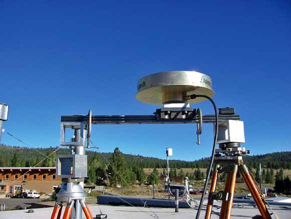
Experimental set up on the roof of the water treatment plant in Mammoth Lakes; the experimental set-up uses two tripods to hold the translation assembly. (from figure 2)
For the past decade, the USGS has been monitoring deformation at various locations in the western United States using continuous GPS. The main focus of these measurements are estimates of displacement averaged over one day. Essentially, these consist of recording at 30 seconds intervals the carrier-frequency phase-data (equivalent to travel-time) between a GPS receiver and the GPS satellite network. In turn, these observations, which are converted to pseudo-ranges, are processed using one of the "research grade" programs (GIPSY, Zumberge et al., or GAMIT, http://www-gpsg.mit.edu/~simon/gtgk) to estimate the position of the GPS receiver averaged over 24 hours. However, it is possible and desirable to estimate the position of the receiver (actually the antenna) more frequently and to do this within a few seconds of the time actual measurement (known as real-time). A recent example, the 2004 Magnitude 6, Parkfield, California earthquake, demonstrated that having GPS estimates of position more frequently than simply a daily average is required if one requires discrimination between co-seismic and post-seismic deformation. The high-rate estimates of position obtained at Parkfield show that post-seismic deformation started less than one-hour after the mainshock and that this deformation was roughly the same magnitude as the co-seismic deformation. The high-rate solutions for Parkfield were done by others including Yehuda Bock at UCSD and Kristine Larson at Univ. of Colorado, but not the USGS.
The Parkfield experience points out the need for an in-house capability by the USGS to be able to accurately measure co-seismic displacements and other rapid, deformation signals using GPS. This applies to both the Earthquake and Volcano Hazard programs. Although at many locations where we monitor deformation, we have strainmeters and tiltmeters in addition to GPS which, in principle, are far more sensitive to rapid deformation over periods of less than a day (Langbein and Bock, 2004). But, not all locales include strain and tiltmeters. Thus, having the capability to extract signals with periods of less than a day is desirable since the distribution of GPS is more extensive than strain and tilt.
Download this report as a 37-page PDF file (of2006-1235.pdf; 4.2 MB)
For questions about the content of this report, contact John Langbein
Download a copy of the latest version of Adobe Reader for free.
|
Help |
PDF help |
Publications main page |
| Western Open-File Reports for 2006 |
| Geologic Division |
Earthquake Hazards Program
|

![]() U.S. Department of the Interior | U.S. Geological Survey
U.S. Department of the Interior | U.S. Geological Survey
URL: http://pubs.usgs.gov/of/2006/1235/
Page Contact Information: Michael Diggles
Page Last Modified: October 25, 2006