U.S. Geological Survey Open-File Report 2006-1238
Prepared in cooperation with the National Park Service
|
||
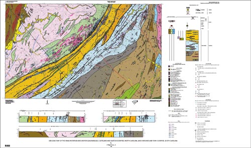 |
This geologic map covers an area of the Piedmont along the North Carolina–South Carolina State line. It straddles a regional geological boundary between the Inner Piedmont terrane and the Kings Mountain sequence on the western flank of the Carolina terrane. The Kings Mountain and Grover quadrangles are located along the Interstate Highway 85 corridor. They encompass most of Kings Mountain National Military Park, Crowders Mountain State Park in North Carolina, and much of Kings Mountain State Park in South Carolina. The area has a remarkable diversity of rock formations and mineral resources, and mining has played a significant role in its history from the 1700s to the present. Geologic map plate: PDF [10.6-MB] | Adobe Illustrator [10.8-MB zip file] Text of Open-File Report 2006-1238 [224-KB PDF file] Description of Map Units [147-KB PDF file] GIS shape files [896-KB zip file] GIS metadata [72-KB zip file] Poster of geologic map with shaded relief added [30.6-MB PDF file] Get Adobe Reader free of charge |
|

![]() U.S. Department of the Interior | U.S. Geological Survey
U.S. Department of the Interior | U.S. Geological Survey
URL: http://pubsdata.usgs.gov/pubs/of/2006/1238/index.html
Page Contact Information: Publications Service Center 4
Page Last Modified: 22:02:44 Sat 12 Jan 2013

