Coastal and Marine Geology
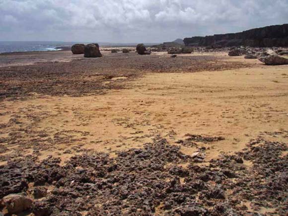
Panorama view on the north coast of Bonaire at Boka Kokolishi in March 2006 showing (from left to right), Caribbean Sea, modern sea cliff, scattered boulders and sand deposits on an elevated rock platform, and a paleo-seacliff. Wave swept zone and fresh sand deposits were products of Hurricane Ivan in September 2004.
This report presents an overview of preliminary geological investigations and recommended future research activities in the Caribbean region pertaining to coastal hazards with an emphasis on establishing tsunami risk for U.S. territories. Fieldwork was conducted in March 2006 on the islands of Bonaire, Puerto Rico, and Guadeloupe to evaluate the stratigraphic records of extreme wave deposits as possible indicators of paleotsunami recurrence. Morphological, sedimentological, and stratigraphic evidence indicate that shore-parallel coral rubble deposits composed of coarse clasts and sand that are 10s of meters wide and several meters thick are depositional complexes that have accumulated for a few centuries or millennia, and are not entirely the result of one or a few tsunamis as previously reported. The origins of boulder fields on elevated rock platforms of the Caribbean islands are more complicated than the origins of ridge complexes because boulder fields can be constructed by either storm waves or tsunamis. What is needed now for more conclusive interpretations is a systematic sedimentological approach to deposit analysis and a set of criteria for distinguishing between coarse clast storm and tsunami deposits. Assembling more field data from other Caribbean islands, analyzing stratigraphic deposits on Puerto Rico and Bonaire, and investigating boulder field deposits resulting from a historical tsunami can accomplish this. Also needed are improved sediment transport models for coarse clasts that can be used to estimate the competence and capacity of tsunamis and storms waves and to determine whether a deposit likely was created by a tsunami or extreme storm. Improved models may also be useful for reconstructing the magnitude of extreme wave events.
Download this report as a 46-page PDF file in standard resolution (of2006-1293.pdf; 3.9 MB)
Download this report as a 46-page PDF file in high resolution (of2006-1293-prn.pdf; 48.6 MB)
For questions about the content of this report, contact Robert Morton
Download a copy of the latest version of Adobe Reader for free.
|
Help |
PDF help |
Publications main page |
| Western Open-File Reports for 2006 |
| Geologic Division |
Coastal and Marine Geology
|

![]() U.S. Department of the Interior | U.S. Geological Survey
U.S. Department of the Interior | U.S. Geological Survey
URL: http://pubs.usgs.gov/of/2006/1293/
Page Contact Information: Michael Diggles
Page Last Modified: October 30, 2006