Geophysical Unit of Menlo Park, Calif.
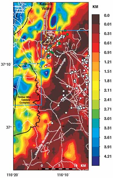
Thickness of Cenozoic deposits based on the inversion of gravity data (from figure 8)
A three-dimensional inversion of gravity data from the Rainier Mesa area and surrounding regions reveals a topographically complex pre-Cenozoic basement surface. This model of the depth to pre-Cenozoic basement rocks is intended for use in a 3D hydrogeologic model being constructed for the Rainier Mesa area. Prior to this study, our knowledge of the depth to pre-Cenozoic basement rocks was based on a regional model, applicable to general studies of the greater Nevada Test Site area but inappropriate for higher resolution modeling of ground-water flow across the Rainier Mesa area. The new model incorporates several changes that lead to significant improvements over the previous regional view. First, the addition of constraining wells, encountering old volcanic rocks lying above but near pre-Cenozoic basement, prevents modeled basement from being too shallow. Second, an extensive literature and well data search has led to an increased understanding of the change of rock density with depth in the vicinity of Rainier Mesa. The third, and most important change, relates to the application of several depth-density relationships in the study area instead of a single generalized relationship, thereby improving the overall model fit. In general, the pre-Cenozoic basement surface deepens in the western part of the study area, delineating collapses within the Silent Canyon and Timber Mountain caldera complexes, and shallows in the east in the Eleana Range and Yucca Flat regions, where basement crops out. In the Rainier Mesa study area, basement is generally shallow (< 1 km). The new model identifies previously unrecognized structures within the pre-Cenozoic basement that may influence ground-water flow, such as a shallow basement ridge related to an inferred fault extending northward from Rainier Mesa into Kawich Valley.
Download this report as a 28-page PDF file (of2006-1299.pdf; 3.7 MB)
For questions about the content of this report, contact Tom Hildenbrand
Download a copy of the latest version of Adobe Reader for free.
|
Help |
PDF help |
Publications main page |
| Western Open-File Reports for 2006 |
| Geologic Division |
Geophysical Unit of Menlo Park, Calif. (GUMP)
|

![]() U.S. Department of the Interior | U.S. Geological Survey
U.S. Department of the Interior | U.S. Geological Survey
URL: http://pubs.usgs.gov/of/2006/1299/
Page Contact Information: Michael Diggles
Page Last Modified: November 17, 2006