Open-File Report 2006–1329
Abstract
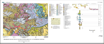
The geologic map of the White Sulphur Springs Quadrangle, scale 1:100,000, was made as part of the Montana Investigations Project to provide new information on the stratigraphy, structure and geologic history of this area in west-central Montana. The quadrangle encompasses about 4,200 square km (1,625 square mi), across most of the Little Belt Mountains, Castle Mountains, and upper drainage areas of the North Fork of the Smith River, North Fork of the Musselshell River, and the Judith River. PurposeThe geologic map of the White Sulphur Springs quadrangle, Montana, provides a summary of mainly new and selected existing geologic information for public use and use by Federal, State, and local governmental agencies for land-use planning, including assessment of natural resources, natural hazards, recreations potential, and land-use management. When used in conjunction with subsurface data, the map can provide information applicable to evaluation of surface water and ground water occurrences and potential. |
Posted April 2007
|
Reynolds, M.W., and Brandt, T.R., 2007, Preliminary geologic map of the White Sulphur Springs 30' x 60' quadrangle, Montana: U.S. Geological Survey Open-File Report 2006-1329, scale 1:100,000.

![]() U.S. Department of the Interior | U.S. Geological Survey
U.S. Department of the Interior | U.S. Geological Survey
URL: http://pubsdata.usgs.gov/pubs/of/2006/1329/index.html
Questions or Assistance: Contact USGS
Last modified: Saturday, 12-Jan-2013 22:28:17 EST
