
Open-File Report 2006-1357
![]() Title |
Introduction |
Setting |
Methods |
Overview |
Interpretation |
Discussion |
Data Catalog |
Acknowledgments |
References |
Figures |
Bottom Photographs |
Sediment Data |
Contacts
Title |
Introduction |
Setting |
Methods |
Overview |
Interpretation |
Discussion |
Data Catalog |
Acknowledgments |
References |
Figures |
Bottom Photographs |
Sediment Data |
Contacts
 |
||
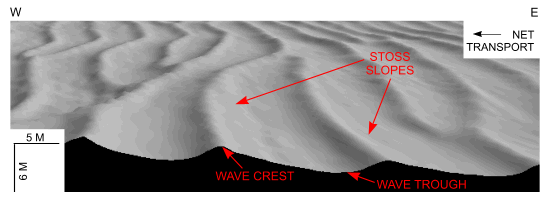
Figure 32. Detailed perspective view of the bedforms south of Nashawena Island from the DTM produced during NOAA survey H11076. Note that the stoss slopes face east indicating net westward transport. Location of view is shown in figure 22. | ||

![]() U.S. Department of the Interior |
U.S. Geological Survey
U.S. Department of the Interior |
U.S. Geological Survey
URL: http://pubsdata.usgs.gov/pubs/of/2006/1357/html/fig32.html
Page Contact Information: GS Pubs Web Contact
Page Last Modified: Thursday, 19-Sep-2024 14:04:35 EDT


