Open-File Report 2007–1074
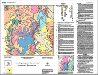 
This geologic map is based entirely on new mapping by Thompson and Machette, whereas the geophysical data and interpretations were supplied by Drenth. The map area includes most of San Pedro Mesa, a basalt covered mesa that is uplifted as a horst between the Southern Sangre de Cristo fault zone (on the west) and the San Luis fault zone on the east. The map also includes most of the Sanchez graben, a deep structural basin that lies between the San Luis fault zone (on the west) and the Central Sangre de Cristo fault zone on the east. The oldest rocks in the map area are Proterozoic granites and Paleozoic sedimentary rocks, which are only exposed in a small hill on the west- central part of the mesa. The low hills that rise above San Pedro mesa are comprised of middle(?) Miocene volcanic rocks that are undated, but possibly correlative with mapped rocks to the east of Sanchez Reservoir. The bulk of the map area is comprised of the Servilleta Basalt, a regional series of flood basalts of Pliocene age. The west, north, and northeast margins of the mesa are covered by extensive landslide deposits that rest on poorly exposed sediment of the Santa Fe Group. Rare exposures of the sediment are comprised of siltstones, sandstones, and minor fluvial conglomerates. Most of the low ground surrounding the mesa is covered by surficial deposits of Quaternary age. The piedmont alluvium is subdivided into three Pleistocene units, and three Holocene units. The oldest Pleistocene gravel (unit Qao) forms an extensive coalesced alluvial fan and piedmont surface that is known as the Costilla Plains. This surface extends west from San Pedro Mesa to the Rio Grande. The primary geologic hazards in the map are from earthquakes and landslides. There are three major fault zones in the area (as discussed above), and they all show evidence for late Pleistocene to possible Holocene movement. Two generations of landslides are mapped (younger and older), and both may have seismogenic origins. |
Version 1.0 Posted June 2007
|
Thompson, R.A., Machette, M.N., and Drenth, B.J., 2007, Preliminary geologic map of the Sanchez Reservoir quadrangle and eastern part of the Garcia quadrangle, Costilla County, Colorado: U.S. Geological Survey Open-File Report 2007-1074, 1 plate.

![]() U.S. Department of the Interior | U.S. Geological Survey
U.S. Department of the Interior | U.S. Geological Survey
URL: http://pubsdata.usgs.gov/pubs/of/2007/1074/index.html
Questions or Assistance: Contact USGS
Last modified: Wednesday, 07-Dec-2016 20:16:18 EST
