Pacific Island Ecosystems Research Center
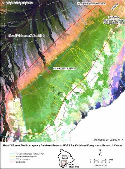
Study area and administrative boundaries overlaid on a natural color Landsat ETM satellite image (path/row 62/47; dated January 31, 2001). Elevation contours are shown in 500-meter intervals (from figure 1).
In the Ka‘ū District on the Island of Hawai‘i lies perhaps the largest intact stretch of native rainforest in the state, one of critical importance to the conservation of Hawaiian forest birds. The original vegetation of this 47,408 ha (474 km2) tract is native forest, woodland, and shrubland, although the southwest and subalpine margins have been historically grazed and are pasture to varying degrees. The tract is centered on the Ka‘ ū and KapĀpala Forest Reserves owned and managed by the State of Hawai‘i, and include inholdings belonging to Kamehameha Schools and The Nature Conservancy. Recently, Kahuku Ranch to the north and southwest was incorporated into Hawai‘i Volcanoes National Park. Together these lands harbor the second largest concentration of native forest birds on Hawai‘i Island, including populations of three endangered Hawaiian honeycreepers.
To understand the status of forest birds in the Ka‘ū forest, it has been a conservation goal to survey and monitor their populations. This report presents analysis of the 30-year history of monitoring in this important bird habitat. The objectives of the study were to (1) examine the distribution of native and exotic forest birds; (2) estimate population sizes; and (3) estimate trends in population density. The five forest bird surveys analyzed herein were conducted between 1976 and 2005 by the State of Hawai‘i Division of Forestry and Wildlife, the National Park Service, U.S. Geological Survey, and U.S. Fish and Wildlife Service, and include a total of 54 transects and 1,952 stations. The most recent of these surveys, in 2005, sampled bird populations at a much finer scale than previous surveys, and although limited to elevations above 1,500 m, these surveys are the first to give up-to-date information at greater accuracy for bird populations in habitat above the elevational zone afflicted by mosquito-borne bird diseases (Tweed et al. In review). Species-habitat models were developed to predict densities for the entire study area for 7 of the 11 species treated herein.
The distributions of the three endangered species - ‘Akiapōlā‘au, Hawai‘i Creeper, Hawai‘i ‘Ākepa — are restricted to a narrow (3 — 4 km) band of forest and adjacent woodland above 1,500 m. These species show no trend in density at high elevations, but have been extirpated from habitat below 1,500 m since the 1976 Hawaii Forest Bird Survey. Current population estimates for ‘Akiapōlā‘au are 1,073 (± 307 SE) birds, for Hawai‘i Creeper, 2,268 (± 797 SE), and for Hawai‘i ‘Ākepa, 2,556 (± 863 SE).
With a population numbering about 14,600 (± 4,300 SD) birds, the Hawai‘i ‘Elepaio also exhibits a restricted distribution and is mostly concentrated towards the northeastern third of the study area. There is tentative evidence of a contraction in the species’ range and a decline in density since 1976. Encouragingly, about two-thirds of its population occurs below 1,500 m and may indicate that Hawai‘i ‘Elepaio are either to some degree resistant to avian malaria or the disease may not be as prevalent in this area as it is in other montane habitats.
‘I‘iwi are common within much of the forest habitat in the study area, and the population size was estimated at about 78,000 (± 9,000 SD) individuals. As much as 40% of the ‘I‘iwi population may be seasonally present below 1,500 m. The greater part of this low elevation distribution occurs in drier forest in the northeastern third of the study area. Given the observed decline in ‘I‘iwi in Ka‘ū (and elsewhere) and the species’ susceptibility to avian malaria, the population would likely benefit from habitat restoration and protection in this area.
Ōma‘o, Hawai‘i ‘Amakihi, and ‘Apapane are widely distributed in the study area, and have sizable populations (about 82,000 [± 7,000 SD], 155,000 [± 9,000 SD], and 492,000 [± 24,000 SD], respectively). The proportion of these species’ populations observed and predicted to occur below 1,500 m ranged from 34% (Hawai‘i ‘Amakihi) and 41% (‘Apapane) up to 64% (Ōma‘o). Their occurrence, in places down to 700 m, indicates that these birds may be survivors of prior malaria infections. The apparent downward trends detected for Ōma‘o and Hawai‘i ‘Amakihi are in doubt given the observed high variability in density. The upward trend in ‘Apapane density at low elevations appears reliable.
The densities of non-native birds appear stable and relatively low at upper elevations. Red-billed Leiothrix is the only non-native species to demonstrate an upward trend at low elevations. The population size of Red-billed Leiothrix, Japanese White-eye and Northern Cardinal were estimated at about 39,000 (± 5,000 SD), 245,000 (± 33,000 SD), and 11,000 (± 2,500 SE) birds, respectively.
The difficulty in reliably discerning trends in density and changes in the extent of a species’ range indicate that the current survey program should be reevaluated. We propose the establishment of a comprehensive monitoring framework that intensively samples select areas and extensively samples a larger region to provide both the “close-ups” and the “big picture” needed to anticipate and follow changes in bird numbers, occurrence and distribution. The relative uncertainty associated with densities predicted by species-habitat models is greatest in under-sampled habitats and where observed density is low and variable. Surveys should be designed to provide a broader coverage of sampled habitats or specific areas within selected species’ range. To a large extent, such a program can build on recent surveys in the region.
The current practice of conducting surveys in late winter and spring is supported by the data, which show that mid-spring counts coincide with the period when the majority of species are most vocal in Ka‘ū. For trend analyses, it is important to maintain as consistent a survey schedule as logistically feasible to minimize measurement error.
Variable circular-plot and other count methods are relatively ineffective at tracking trends of rare species such as ‘Akiapōlā‘au, Hawai‘i Creeper and Hawai‘i ‘Ākepa. Demographic studies for these species should be considered in the Ka‘ū study area.
Download this report as a 106-page PDF document (of2007-1076.pdf; 8 MB)
For questions about the content of this report, contact Marcos Gorresen
Suggested citation and version history
Download a free copy of the latest version of Adobe Reader.
|
Help |
PDF help |
Publications main page | Western Open-File Reports for 2007 |
| Biology | Pacific Island Ecosystems Research Center |
This report is available only on the Web

![]() U.S. Department of the Interior | U.S. Geological Survey
U.S. Department of the Interior | U.S. Geological Survey
URL: https://pubs.usgs.gov/of/2007/1076/
Page Contact Information: Michael Diggles
Page Created: June 3, 2008
Page Last Modified: January 15, 2009
(mfd)