Report Site Map > Monitoring Network Used to Estimate Delivery of Streamflow and Nutrients to the Gulf of Mexico
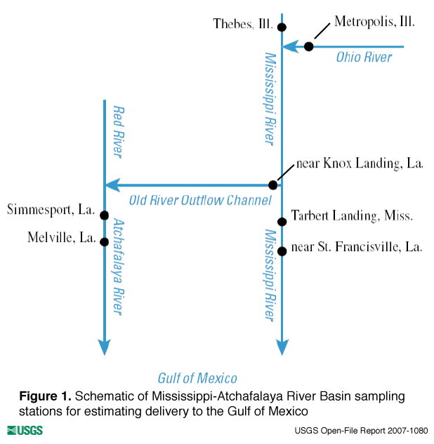
Nutrient fluxes from the Mississippi-Atchafalaya River Basin to the Gulf of Mexico are calculated as the sum of nutrient loads from the Mississippi and Atchafalaya Rivers. Downstream sampling stations were chosen that had long-term stream discharge and water-quality data so that the load estimates provide both a long-term record and a good measure of the delivery of nutrients to the Gulf. All the stations used in load estimation analysis are shown in figure 1. Water-quality and stream-discharge data are not measured at the same station. However, these stations are located nearby and are considered to reflect similar chemical and flow conditions. Mississippi River nutrient fluxes are estimated using water quality from the station near St. Francisville, Louisiana, and stream discharge from the station at Tarbert Landing, Mississippi. Atchafalaya River nutrient fluxes are estimated using water quality from the station at Melville, Louisiana, and stream discharge from the station at Simmesport, Louisiana. The statistical load estimation procedure for Mississippi River nutrient fluxes also incorporates the flow diverted to the Atchafalaya River via the Old River Outflow Channel as measured at Knox Landing along with flows from two upstream stations, the Mississippi River at Thebes, Illinois, and the Ohio River at Metropolis, Illinois. Water-quality and stream-discharge stations are summarized in table 1 and their relative locations in the hydrologic framework are indicated in figure 1. |
| Station Name | Station ID |
Drainage Area (km2) |
Data Type |
Source |
|---|---|---|---|---|
| Mississippi River near St. Francisville, La.1 | 07373420 | 2,965,404 | quality | USGS |
| Mississippi River at Tarbert Landing, Miss. | 01100Q | 2,913,500 | flow | USACE |
| Lower Atchafalaya River at Melville, La.2 | 07381495 | 241,690 | quality | USGS |
| Atchafalaya River at Simmesport, La. | 03045Q | 226,800 | flow | USACE |
| Old River Outflow Channel near Knox Landing, La. (Total Outflow) | 02600Q | -- | flow | USACE |
| Ohio River at Metropolis, Ill. | 03611500 | 526,000 | flow | USGS |
| Mississippi River at Thebes, Ill. | 07022000 | 1,847,000 | flow | USGS |
| 1 | = | Flow for this station is measured at Mississippi River at Tarbert Landing, Mississippi. |
| 2 | = | Flow for this station is calculated using measurements at Atchafalaya River at Simmesport, Louisiana, and the Old River Outflow Channel near Knox Landing, Louisiana. |
| USGS | = | U.S. Geological Survey |
| USACE | = | U.S. Army Corps of Engineers |
| -- | = | Not applicable |
Report Site Map > Monitoring Network Used to Estimate Delivery of Streamflow and Nutrients to the Gulf of Mexico

![]() U.S. Department of the Interior |
U.S. Geological Survey
U.S. Department of the Interior |
U.S. Geological Survey
URL: http://pubsdata.usgs.gov/pubs/of/2007/1080/of-2007-1080/gulf_site.html
Page Contact Information: GS Pubs Web Contact
Page Last Modified: Wednesday, 05-Mar-2025 14:48:55 EST