
Open-File Report 2007-1138
Sea-Floor Character and Sedimentary Processes of Great Round Shoal Channel, Offshore Massachusetts
![]() Title |
Introduction |
Setting |
Methods |
Overview |
Discussion |
Interpretation |
Data Catalog |
Acknowledgments |
References |
Figures |
Bottom Photographs |
Sediment Data |
Contacts
Title |
Introduction |
Setting |
Methods |
Overview |
Discussion |
Interpretation |
Data Catalog |
Acknowledgments |
References |
Figures |
Bottom Photographs |
Sediment Data |
Contacts
 |
||
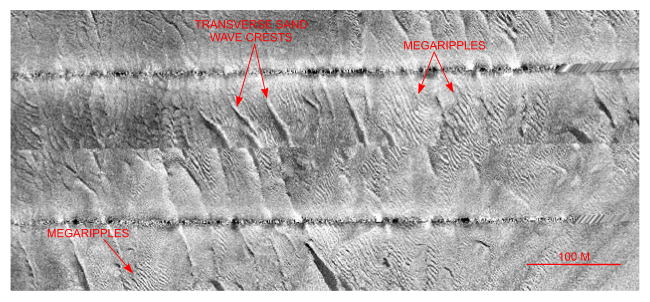
Figure 27. Detailed planar view of the sidescan-sonar mosaic produced during NOAA survey H11079 showing relatively straight to sinuous alternating bands of high and low backscatter ("tiger-stripe") pattern indicative of transverse sand waves. Note presence of megaripples on the stoss slopes indicative of active transport. Location of view is shown in figure 22. | ||

![]() U.S. Department of the Interior |
U.S. Geological Survey
U.S. Department of the Interior |
U.S. Geological Survey
URL: http://pubsdata.usgs.gov/pubs/of/2007/1138/html/fig27.html
Page Contact Information: GS Pubs Web Contact
Page Last Modified: Friday, 03-Jan-2025 15:03:35 EST


