
Open-File Report 2007-1138
Sea-Floor Character and Sedimentary Processes of Great Round Shoal Channel, Offshore Massachusetts
![]() Title |
Introduction |
Setting |
Methods |
Overview |
Discussion |
Interpretation |
Data Catalog |
Acknowledgments |
References |
Figures |
Bottom Photographs |
Sediment Data |
Contacts
Title |
Introduction |
Setting |
Methods |
Overview |
Discussion |
Interpretation |
Data Catalog |
Acknowledgments |
References |
Figures |
Bottom Photographs |
Sediment Data |
Contacts
 |
||
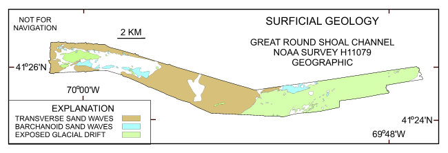
Figure 41. Interpretation of the DTM and sidescan-sonar mosaic from NOAA survey H11079 of Great Round Shoal Channel. Shown are the areas characterized by exposed glacial drift, transverse sand waves, and barchanoid sand waves. White areas within the study area are primarily relatively flat and megarippled reworked Holocene sand. | ||

![]() U.S. Department of the Interior |
U.S. Geological Survey
U.S. Department of the Interior |
U.S. Geological Survey
URL: http://pubsdata.usgs.gov/pubs/of/2007/1138/html/fig41.html
Page Contact Information: GS Pubs Web Contact
Page Last Modified: Friday, 03-Jan-2025 15:07:08 EST


