Astrogeology Research Program
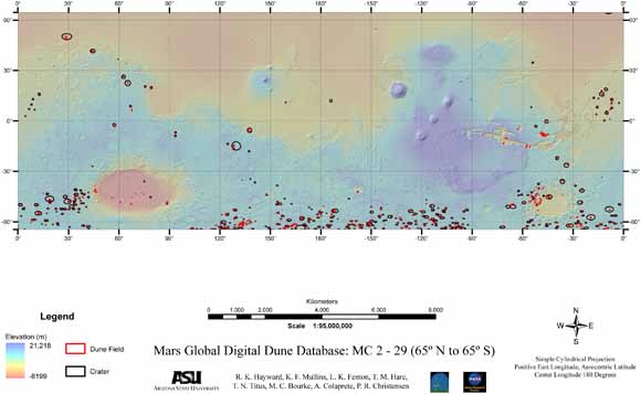
The Mars Global Digital Dune Database presents data and describes the methodology used in creating the database. The database provides a comprehensive and quantitative view of the geographic distribution of moderate- to large-size dune fields from 65° N to 65° S latitude and encompasses ~ 550 dune fields. The database will be expanded to cover the entire planet in later versions. Although we have attempted to include all dune fields between 65° N and 65° S, some have likely been excluded for two reasons: 1) incomplete THEMIS IR (daytime) coverage may have caused us to exclude some moderate- to large-size dune fields or 2) resolution of THEMIS IR coverage (100m/pixel) certainly caused us to exclude smaller dune fields. The smallest dune fields in the database are ~ 1 km2 in area. While the moderate to large dune fields are likely to constitute the largest compilation of sediment on the planet, smaller stores of sediment of dunes are likely to be found elsewhere via higher resolution data. Thus, it should be noted that our database excludes all small dune fields and some moderate to large dune fields as well. Therefore the absence of mapped dune fields does not mean that such dune fields do not exist and is not intended to imply a lack of saltating sand in other areas.
Where availability and quality of THEMIS visible (VIS) or Mars Orbiter Camera narrow angle (MOC NA) images allowed, we classifed dunes and included dune slipface measurements, which were derived from gross dune morphology and represent the prevailing wind direction at the last time of significant dune modification. For dunes located within craters, the azimuth from crater centroid to dune field centroid was calculated. Output from a general circulation model (GCM) is also included. In addition to polygons locating dune fields, the database includes over 1800 selected Thermal Emission Imaging System (THEMIS) infrared (IR), THEMIS visible (VIS) and Mars Orbiter Camera Narrow Angle (MOC NA) images that were used to build the database.
The database is presented in a variety of formats. It is presented as a series of ArcReader projects which can be opened using the free ArcReader software. The latest version of ArcReader can be downloaded at http://www.esri.com/software/arcgis/arcreader/download.html. The database is also presented in ArcMap projects. The ArcMap projects allow fuller use of the data, but require ESRI ArcMap® software. Multiple projects were required to accommodate the large number of images needed. A fuller description of the projects can be found in the Dunes_ReadMe file and the ReadMe_GIS file in the Documentation folder. For users who prefer to create their own projects, the data is available in ESRI shapefile and geodatabase formats, as well as the open Geography Markup Language (GML) format. A printable map of the dunes and craters in the database is available as a Portable Document Format (PDF) document. The map is also included as a JPEG file. ReadMe files are available in PDF and ASCII (.txt) files. Tables are available in both Excel (.xls) and ASCII formats.
Download the Readme file for a fuller description of the project files (Dunes_ReadMe.pdf; 152 kB).
Readme file in ASCII, a plain-text version (Dunes_ReadMe.txt; 64 kB).
Mars Global Digital Dune Database includes the following .zip compressed files of directories and subdirectories:
ArcMapProjects -- Contains ArcMap projects and "Layers" folder (included in "Entire File Collection" linked below)
ArcReaderProjects -- Contains all projects described above in .pmf format. The free software, ArcReader will open these files (included in "Entire File Collection" linked below)
Documentation.zip -- Contains the following documentation: Database_Map (a 1:95,000,000 scale), ReadMe_Abstract_Purpose_Process, ReadMe_GIS, ReadMe_Softcopy, and References (10.4 MB)
Geodatabase.zip -- Contains two folders, each containing one geodatabase: Geocentric and Sinu (8.8 MB)
GML.zip -- Contains a geocentric Geography Markup Language (GML) version of the 9 layers in the database (3.3 MB)
Images -- Contains all the images projected and available in the above described ArcMap and ArcReader projects (included in "Entire File Collection" linked below)
Metadata.zip -- Contains Metadata files for the database layers in text and HTML formats. These files describe the layers and their associated fields (144 kB)
Shapefiles.zip -- Contains background shapefiles that are not part of the dune database and shapefile versions of the dune database (57.8 MB)
Tables.zip -- Contains Excel and tab delimited text formats of the dune database attribute table (336 kB)
of2007-1158.zip -- This large file is the entire publication with all of its folders and data as a single download (1.76 Gigabytes)
For questions about the content of this report, contact Rosalyn Hayward
Suggested citation and version history
Download a current version of Adobe Reader for free
| Help
| PDF help
| Publications main page |
Western Open-File Reports for 2007
|
| Geologic Division | Astrogeology Research Program
|
This report is available only on the Web

![]() U.S. Department of the Interior | U.S. Geological Survey
U.S. Department of the Interior | U.S. Geological Survey
URL: https://pubs.usgs.gov/of/2007/1158/
Page Contact Information: Michael Diggles
Page Last Modified: January 9, 2008