
Open-File Report 2007-1191
![]() Title |
Introduction |
Setting |
Methods |
Results |
Discussion |
Data Catalog |
Acknowledgments |
References |
Figures |
Contacts
Title |
Introduction |
Setting |
Methods |
Results |
Discussion |
Data Catalog |
Acknowledgments |
References |
Figures |
Contacts
 |
||
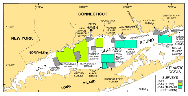
Figure 2. Map showing location of the bathymetric and backscatter surveys completed in Long Island Sound. Multibeam surveys by the NOAA ship Thomas Jefferson are shown in dark green. The sidescan-sonar and bathymetric surveys completed by the NOAA ship Rude are shown in light green (Poppe and others, 2006a): H11043--Poppe and others (2004); H11044--McMullen and others (2005); and H11045--Beaulieu and others (2005). Also shown are the sites of USGS sidescan-sonar surveys in gray: Norwalk--Twichell and others (1997); Milford--Twichell and others (1998); New Haven Harbor and New Haven Dumping Grounds--Poppe and others (2001); Roanoke Point--Poppe and others (1999a); Falkner Island--Poppe and others (1999b); Hammonasset--Poppe and others (1997); Niantic Bay--Poppe and others (1998a); New London--Zajac and others (2000, 2003); Fishers Island Sound--Poppe and others (1998b). | ||

![]() U.S. Department of the Interior |
U.S. Geological Survey
U.S. Department of the Interior |
U.S. Geological Survey
URL: http://pubsdata.usgs.gov/pubs/of/2007/1191/html/fig2.html
Page Contact Information: GS Pubs Web Contact
Page Last Modified: Wednesday, 04-Dec-2024 14:19:36 EST


