
Open-File Report 2007-1191
![]() Title |
Introduction |
Setting |
Methods |
Results |
Discussion |
Data Catalog |
Acknowledgments |
References |
Figures |
Contacts
Title |
Introduction |
Setting |
Methods |
Results |
Discussion |
Data Catalog |
Acknowledgments |
References |
Figures |
Contacts
 |
||
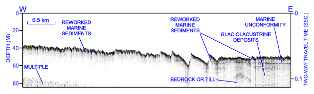
Figure 24. CHIRP high-resolution seismic-reflection profile from survey H11361 showing large transverse sand waves southeast of Six Mile Reef. Bedform asymmetry indicates net sediment transport is toward the west. Note that the deeper troughs extend into underlying postglacial marine deltaic deposits suggesting that erosion is ongoing. Location of seismic profile is shown in figure 15. | ||

![]() U.S. Department of the Interior |
U.S. Geological Survey
U.S. Department of the Interior |
U.S. Geological Survey
URL: http://pubsdata.usgs.gov/pubs/of/2007/1191/html/fig24.html
Page Contact Information: GS Pubs Web Contact
Page Last Modified: Thursday, 05-Dec-2024 08:30:05 EST


