
Open-File Report 2007-1191
![]() Title |
Introduction |
Setting |
Methods |
Results |
Discussion |
Data Catalog |
Acknowledgments |
References |
Figures |
Contacts
Title |
Introduction |
Setting |
Methods |
Results |
Discussion |
Data Catalog |
Acknowledgments |
References |
Figures |
Contacts
 |
||
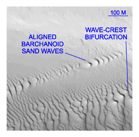
Figure 26. Detailed planar view of multibeam bathymetry from survey H11361 showing asymmetrical transverse and barchanoid sand waves suggesting net westward transport. Note sharp contacts between sand waves and surrounding flat sea floor and bifurcation of transverse wave crests near the edge of that field. Location of detailed view is shown in figure 15. | ||

![]() U.S. Department of the Interior |
U.S. Geological Survey
U.S. Department of the Interior |
U.S. Geological Survey
URL: http://pubsdata.usgs.gov/pubs/of/2007/1191/html/fig26.html
Page Contact Information: GS Pubs Web Contact
Page Last Modified: Thursday, 05-Dec-2024 08:31:08 EST


