
Open-File Report 2007-1191
![]() Title |
Introduction |
Setting |
Methods |
Results |
Discussion |
Data Catalog |
Acknowledgments |
References |
Figures |
Contacts
Title |
Introduction |
Setting |
Methods |
Results |
Discussion |
Data Catalog |
Acknowledgments |
References |
Figures |
Contacts
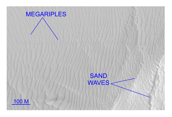 | ||
Figure 30. Detailed planar view of multibeam bathymetry from survey H11252 showing that sand-wave and megaripple amplitude decreases markedly westward of Six Mile Reef. Trough-to-crest sand-wave amplitude exceeds 4.7 m in eastern part of the image, but sand waves are absent and megaripple amplitudes average only about 0.25 m along western edge. Location of detailed view is shown in figure 16. | ||

![]() U.S. Department of the Interior |
U.S. Geological Survey
U.S. Department of the Interior |
U.S. Geological Survey
URL: http://pubsdata.usgs.gov/pubs/of/2007/1191/html/fig30.html
Page Contact Information: GS Pubs Web Contact
Page Last Modified: Thursday, 05-Dec-2024 08:45:28 EST


