Geophysical Unit of Menlo Park, Calif. (GUMP)

U.S. Geological Survey
Open-File Report 2007-1218
version 1.0

Preliminary Isostatic Gravity Map of Joshua Tree National Park and Vicinity, Southern California

By V.E. Langenheim, Shawn Biehler, D.K. McPhee, C.A. McCabe, J.T. Watt, M.L. Anderson, B.A. Chuchel, and P. Stoffer

2007

Abstract

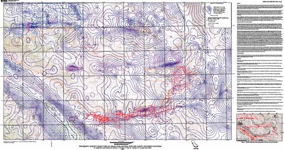
This isostatic residual gravity map is part of an effort to map the three-dimensional distribution of rocks in Joshua Tree National Park, southern California.

This map will serve as a basis for modeling the shape of basins beneath the Park and in adjacent valleys and also for determining the location and geometry of faults within the area. Local spatial variations in the Earth's gravity field, after accounting for variations caused by elevation, terrain, and deep crustal structure, reflect the distribution of densities in the mid- to upper crust. Densities often can be related to rock type, and abrupt spatial changes in density commonly mark lithologic or structural boundaries.
High-density basement rocks exposed within the Eastern Transverse Ranges include crystalline rocks that range in age from Proterozoic to Mesozoic and these rocks are generally present in the mountainous areas of the quadrangle. Alluvial sediments, usually located in the valleys, and Tertiary sedimentary rocks are characterized by low densities. However, with increasing depth of burial and age, the densities of these rocks may become indistinguishable from those of basement rocks. Tertiary volcanic rocks are characterized by a wide range of densities, but, on average, are less dense than the pre-Cenozoic basement rocks. Basalt within the Park is as dense as crystalline basement, but is generally thin (less than 100 m thick; e.g., Powell, 2003).

Isostatic residual gravity values within the map area range from about –44 mGal over Coachella Valley to about 8 mGal between the Mecca Hills and the Orocopia Mountains. Steep linear gravity gradients are coincident with the traces of several Quaternary strike-slip faults, most notably along the San Andreas Fault bounding the east side of Coachella Valley and east-west-striking, left-lateral faults, such as the Pinto Mountain, Blue Cut, and Chiriaco Faults (Fig. 1). Gravity gradients also define concealed basin-bounding faults, such as those beneath the Chuckwalla Valley (e.g. Rotstein and others, 1976). These gradients result from juxtaposing dense basement rocks against thick Cenozoic sedimentary rocks.

Download the map as a ~65" x 35" PDF file (of2007-1218.pdf; 23.3 MB).

Download the metadata as an ASCII text file (of2007-1218_metadata.txt; 58 kB).

Download the data as an Excel workbook with all of the principal facts of the data used to generate the contours on the map (of2007-1218_data.xls; 1 MB).

Go to the CSV folder to get comma-separated-value files of each of the five sheets in the Excel workbook (544 kB total).


For more about gravity and magnetic data and methods, visit the Geophysical Unit Menlo Park website

For more about geologic mapping in Southern California, visit the SCAMP website

For more about earthquake studies in Southern California, visit the USGS Pasadena Field Office

For questions about the content of this report, contact Vicki Langenheim

Suggested citation and version history


Download a free copy of the current version of Adobe Reader.

| Help | PDF help | Western reports main page | Western Scientific Investigations Maps |
| Geologic Division | Geophysical Unit of Menlo Park, Calif. (GUMP) |


This report is available only on the Web


Accessibility FOIA Privacy Policies and Notices

Take Pride in America home page. USA.gov logo U.S. Department of the Interior | U.S. Geological Survey
URL: https://pubs.usgs.gov/of/2007/1218/
Page Contact Information: Michael Diggles
Page Last Modified: October 18, 2007