Coastal and Marine Geology Program
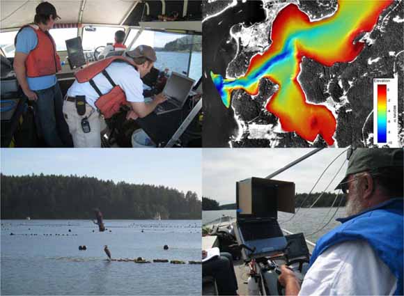
Nearshore bathymetry, substrate type, and circulation patterns in Westcott Bay, San Juan Islands, Washington, were mapped using two acoustic sonar systems, video and direct sampling of seafloor sediments. The goal of the project was to characterize nearshore habitat and conditions influencing eelgrass (Z. marina) where extensive loss has occurred since 1995. A principal hypothesis for the loss of eelgrass is a recent decrease in light availability for eelgrass growth due to increase in turbidity associated with either an increase in fine sedimentation or biological productivity within the bay. To explore sources for this fine sediment and turbidity, a dual-frequency Biosonics sonar operating at 200 and 430 kHz was used to map seafloor depth, morphology and vegetation along 69 linear kilometers of the bay. The higher frequency 430 kHz system also provided information on particulate concentrations in the water column. A boat-mounted 600 kHz RDI Acoustic Doppler Current Profiler (ADCP) was used to map current velocity and direction and water column backscatter intensity along another 29 km, with select measurements made to characterize variations in circulation with tides. An underwater video camera was deployed to ground-truth acoustic data. Seventy one sediment samples were collected to quantify sediment grain size distributions across Westcott Bay. Sediment samples were analyzed for grain size at the Western Coastal and Marine Geology Team sediment laboratory in Menlo Park, Calif. These data reveal that the seafloor near the entrance to Westcott Bay is rocky with a complex morphology and covered with dense and diverse benthic vegetation. Current velocities were also measured to be highest at the entrance and along a deep channel extending 1 km into the bay. The substrate is increasingly comprised of finer sediments with distance into Westcott Bay where current velocities are lower. This report describes the data collected and preliminary findings of USGS Cruise B-6-07-PS conducted between May 31, 2007 and June 5, 2007.
Download this report as a 42-page PDF file (of2007-1305.pdf; 3.6 MB).
For questions about the content of this report, contact Eric Grossman
Suggested citation and version history
Download a free copy of the latest version of Adobe Reader.
|
Help |
PDF help |
Publications main page |
| Western Open-File Reports for 2007 |
| Geology | Coastal and Marine Geology
|

![]() U.S. Department of the Interior | U.S. Geological Survey
U.S. Department of the Interior | U.S. Geological Survey
URL: https://pubs.usgs.gov/of/2007/1305/
Page Contact Information: Michael Diggles
Page Last Modified: October 18, 2007