Open-File Report 2007-1364
U.S. GEOLOGICAL SURVEY
Open-File Report 2007-1364
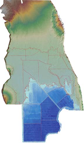 Shaded-relief map of the Wood River Valley created with the use of detailed land-surface elevation data derived from Light Detection and Ranging (LiDAR). Area and depth of inundation, shown in blue, for drained wetlands within the approximate former shoreline of Upper Klamath and Agency Lakes is based on a surface-water stage equal to 4,140 feet NGVD 29. |
Prepared in cooperation with the Bureau of Land Management
By Tana L. Haluska and Daniel T. Snyder
This report presents the parcel and inundation area geographic information system (GIS) layers for various surface-water stages. It also presents data tables containing the water stage, inundation area, and water volume relations developed from analysis of detailed land surface elevation derived from Light Detection and Ranging (LiDAR) data recently collected for the Wood River Valley at the northern margin of Agency Lake in Klamath County, Oregon.
Former shoreline wetlands that have been cut off from Upper Klamath and Agency Lakes by dikes might in the future be reconnected to Upper Klamath and Agency Lakes by breaching the dikes. Issues of interest associated with restoring wetlands in this way include the area that will be inundated, the volume of water that may be stored, the change in wetland habitat, and the variation in these characteristics as surface-water stage is changed. Products from this analysis can assist water managers in assessing the effect of breaching dikes and changing surface-water stage. The study area is in the approximate former northern margins of Upper Klamath and Agency Lakes in the Wood River Valley.
Abstract
Introduction
Explanation of Data
References Cited
Appendix
This report is available online in Portable Document Format (PDF). If you do not have the Adobe Acrobat PDF Reader, it is available for free download from Adobe Systems Incorporated.
Document Accessibility: Adobe Systems Incorporated has information about PDFs and the visually impaired. This information provides tools to help make PDF files accessible. These tools convert Adobe PDF documents into HTML or ASCII text, which then can be read by a number of common screen-reading programs that synthesize text as audible speech. In addition, an accessible version of Adobe Reader 8.0 for Windows (English only), which contains support for screen readers, is available. These tools and the accessible reader may be obtained free from Adobe at Adobe Access.
Send questions or comments about this report to the author, Tana L. Haluska, (503) 251-3212.
For more information about USGS activities in Oregon, visit the USGS Oregon Water Science Center home page.

![]() U.S. Department of the Interior |
U.S. Geological Survey
U.S. Department of the Interior |
U.S. Geological Survey
URL: https://pubs.usgs.gov/ofr/2007/1364
Page Contact Information: Publications Team
Page Last Modified: Wednesday, 07-Dec-2016 20:29:41 EST
