Open-File Report 2007-1366
Sidescan-Sonar Imagery and Surficial Geologic Interpretations of the Sea Floor in Central Rhode Island Sound
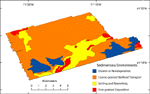
Four different sedimentary environments are present in the study area including environments that are characterized by processes associated with erosion or nondeposition, coarse-grained bedload transport, sorting and reworking, and fine-grained deposition (fig. 14). Erosion or Nondeposition Areas with sedimentary environments characterized by processes of erosion or nondeposition are located in two southward-facing channels incised into the ridge and along the southeastern bathymetric high. These areas with high backscatter in the sidescan-sonar image and clusters of boulders indicate coarser grained sediment reflective of higher energy environments. Coarse-Grained Bedload Transport The majority of the study area is characterized by processes of coarse-grained bedload transport. These areas occur throughout much of the bathymetric highs in the northern, western, and southeastern parts of the study area where there are sand waves. The orientation of the sand-wave crests indicates that sediment transport directions are generally east-west along much of the northern ridge and north-south between the ridge and channel. Sorting and Reworking Areas of sediment sorting and reworking are located in the channels and on parts of the bathymetric highs. These areas tend to have moderate backscatter and the sea floor tends to be relatively smooth. Trawl marks concentrated within areas characterized by these processes suggest a preference by the targeted commercial species for this sea floor environment. Fine-Grained Deposition Although this area was previously mapped by McMaster (1960) as being uniformly sandy, Knebel and others (1982) mapped the bathymetric lows as fine-grained sediment and attributed the difference with McMaster's (1960) study to be from the types and spacing of data. In our study, parts of the channel and bathymetric lows in the southeast and northwest have low backscatter. These areas are interpreted to contain finer grained sediment and to be characterized by depositional environments as Knebel and others (1982) have also mapped them. The water energy in these deeper locations is probably low enough for finer grained sands and perhaps mud to accumulate. |

![]() U.S. Department of the Interior |
U.S. Geological Survey
U.S. Department of the Interior |
U.S. Geological Survey
URL: http://pubsdata.usgs.gov/pubs/of/2007/1366/html/environments.html
Page Contact Information: GS Pubs Web Contact
Page Last Modified: Thursday, 05-Dec-2024 13:31:17 EST