Florida Integrated Science Center
The U.S. Geological Survey is studying coastal hazards and coastal change to improve our understanding of coastal ecosystems and to develop better capabilities of predicting future coastal change. One approach to understanding the dynamics of coastal systems is to monitor changes in barrier-island sub-environments through time. This involves examining morphological and topographic change at time scales ranging from millennia to years and space scales ranging from tens of kilometers to meters. Of particular interest are the processes that produce those changes and determining whether or not those processes are likely to persist into the future. In these analyses of hazards and change, both natural and anthropogenic influences are considered. Quantifying past magnitudes and rates of coastal change and knowing the principal factors that govern those changes are critical to predicting what changes are likely to occur under different scenarios, such as short-term impacts of extreme storms or long-term impacts of sea-level rise. Assateague Island MD/VA was selected for detailed mapping of barrier island morphology and topography because the island offers a diversity of depositional sub-environments that are representative of other barrier islands along the middle Atlantic coast. The geomorphology and sub-environment map emphasizes the origins of the surficial features and it also serves as a basis for documenting which sub-environments are relatively stable, such as the barrier island core, and those that are highly dynamic, such as the beach and active overwash zones.
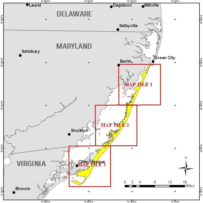
The Geomorphology and Depositional Sub-environments of Assateague Island MD/VA map was divided
up into three map tiles and are provided as is in PDF format. For users of ESRI ArcMap GIS
software, ArcMap 9.2 documents are available and can be read directly from this CD. Links for
the ArcMap 9.2 documents can be found below the map.
Click on the links below or the index map to download the Map Tiles in PDF format. You will need to have the free Adobe Acrobat® Reader installed on your computer to view and print the PDF maps.

The data used as reference for the map include 0.76 meter pixel resolution 1999 Digital Orthophoto Quadrangles (DOQ), 0.25 meter pixel resolution orthorectified aerial photography from 2003, historic aerial photographs, 1 meter pixel resolution NASA Experimental Airborne Advanced Research Lidar (EAARL) survey data from 2003 and 2004, and a 1993 Assateague Island data file showing a preliminary survey of island vegetation. Spatial accuracy of class boundaries vary between 1 and 7 meters due to the variability between the data sources. Each class is stored in a standard format shapefile viewable in any GIS software.
The following link straight to exported metadata text files associated with each class's shapefile. Get the more detailed XML files readable in metadata readers such as ESRI ArcCatalog in the respective data folders above.
Biggs, R.B., 1970, The origin and geologic history of Assateague Island, Maryland and Virginia, in Assateague
        Ecological Studies Final Report, part 1: University of Maryland Natural Resources Institute, Contribution
	no. 446, p.8-41.

Dolan, R., Hayden, B, and Heywood, J., 1977, Atlas of environmental dynamics, Assateague Island National
 	Seashore: National Park Service, Natural Resource Report No. 11, 40 p.

Halsey, S.D., 1978, Late Quaternary geologic history and morphologic development of the barrier system along
	the Delmarva Peninsula of the Mid-Atlantic bight: unpublished PhD. Thesis, University of Delaware, 592 p.

Morton, R.A., 2002, Factors controlling storm impacts on coastal barriers and beaches -- A preliminary basis
	for real-time forecasting: Journal of Coastal Research, v.18, p.486-501.

Morton, R.A., Guy, K.K., Hill, H.W., and Pascoe, T., 2003, Regional morphological responses to the March 1962
	Ash Wednesday storm: Proceedings Coastal Sediments '03, 11 p.

Pendleton, E.A., Williams, S.J. and Thieler, E.R., 2004, Coastal vulnerability assessment of Assateague Island
	National Seashore (ASIS) to sea-level rise: U.S. Geological Survey Open-File Report 2004-1020, Web Only.
	URL: https://pubs.usgs.gov/of/2004/1020/.