Coastal and Marine Geology Program
The United States Geological Survey (USGS), in collaboration with the University of California, Santa Cruz (UCSC), conducted a two-year study of the beach and nearshore coastal processes for the City of Carpinteria and adjacent beaches. The work was performed in response to and worked directly with the United States Army Corps of Engineers (USACE) Project Management Plan (PMP) for the City of Carpinteria: Carpinteria Shoreline, Santa Barbara County, California PMP (June 2003) http://www.spl.usace.army.mil/cms/index.php?option=com_content&task=view&id=487&Itemid=31
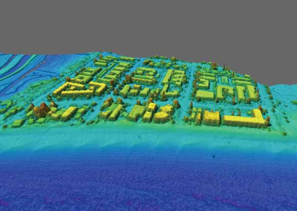
The City of Carpinteria has experienced significant erosion and storm damage over the last decade (Figure 1.1). A USACE reconnaissance survey has shown shoreline retreat rates that approach 2 m/yr in some locations. The goals of this project are to analyze historical trends/changes in the beach and nearshore environment, document local wave and tidal currents, and assess current beach and nearshore conditions in terms of grain size, beach size and shape, seasonal changes, and nearshore bathymetry. In summary, this work serves to quantify sediment sources, transport and sinks throughout the study area to support USACE and the City of Carpinteria coastal management activities.
The objectives of this report are the following:
Carpinteria is a sandy beach in the Santa Barbara littoral cell, a 150 km length of California coastline that extends from Point Conception to Point Mugu (Figure 1.2). It is also part of the broader Santa Barbara Sandshed (detailed below). The study area extends 10 km alongshore from Loon Point southeast to Rincon Point. However, the focus area of this study includes just the City of Carpinteria beach, a 400 m long section between Ash Avenue and Linden Avenue in the center of the broader study area (Figure 1.3). The Carpinteria shoreline analysis that was conducted extends from Sand Point in the west to the Asphaltum outcrop in the east (Figure 1.2). The Santa Barbara Sandshed (watershed + littoral cell) (Revell and others, 2007) extends 245 km from the Santa Maria River in the north, around Point Conception, where the north-south trending U.S. West Coast takes an abrupt turn to a west-east trending shoreline orientation into the Southern California Bight. The sand found on these beaches moves along the coast of southern Santa Barbara and Ventura Counties to the Point Mugu submarine canyon in the south. The Santa Barbara Sandshed consists of a relatively complex coastline with a variety of rocky outcrops, offshore reefs, and relatively narrow beaches. The beaches receive the majority of their sand inputs from four major rivers: the Santa Maria, Santa Ynez, Ventura, and Santa Clara, which drain the sedimentary rocks of the Transverse Range, along with numerous small coastal drainages that pulse sediment during episodic rain events (Inman and Jenkins, 1999). Point Conception in the northwest and the Channel Islands to the south, create a narrow swell window that shelters much of the south facing coast of Santa Barbara County from extreme wave events (Figure 1.2). The Mediterranean climate of southern California results in mild annual temperatures and low precipitation punctuated by episodic and often extreme events, frequently associated with El Nios. Winds and wave heights vary seasonally but focusing of waves into the Santa Barbara Channel drive an almost unidirectional longshore sediment transport from west to east in which beaches narrow during the winter and spring (November to April), and widen during the summer and fall (May to October). Longshore transport rates for the study area are approximated by the 70-yr Santa Barbara Harbor dredge record which shows a mean annual rate of ~230,000 m3 of sand removed per year (Figure 1.4; Patsch and Griggs, 2007). Variability in the dredge volumes stem from sediment supply, navigational depth requirements, and funding. The southern coast of Santa Barbara and Ventura counties are composed mostly of bluff-backed beaches perched on bedrock shore platforms. Along this coast are a few dune-backed beaches that have formed near ephemeral creeks and sloughs, typically controlled by the complex faulting in the Western Transverse Ranges.
This northern end of this sandshed has been characterized as the last remaining stretch of relatively undeveloped coast in southern California. However, this does not imply that it is without anthropogenic influence. Physical alterations to the Santa Barbara coastline began with the completion of the Southern Pacific Railroad in 1901. Physical alterations to the Santa Barbara Sandshed began with dam construction on major rivers: the Santa Ynez River in 1920, the Santa Clara River in 1948, and on the Ventura River in 1955 (Patsch, 2005). In 1927, construction began on the Santa Barbara Harbor and began to impound sand resulting in an erosion wave that propagated downcoast caused by the disruption of longshore transport (Wiegel, 2002). This erosion wave substantially impacted the dune system at Sandyland and the beaches of Carpinteria in the late 1930s. The effects of dam impoundment and shore protection structures on sand delivery to the coast have been quantified in the Santa Barbara littoral cell and show an approximately 40% reduction in sand supplied to the sandshed by the major rivers and bluff erosion, although the great majority of the sand reduction is from stream impoundment (Runyan and Griggs, 2003; Willis and Griggs, 2003). It was predicted that this reduction would correspond with a decline of sand volume dredged at the harbors in the cell. Using dredge records as a proxy for littoral drift, Patsch and Griggs (2007) determined an average longshore transport of sand at Santa Barbara Harbor since 1933 (~230,000 m3/year), and the Ventura Harbor since 1964 (~550,000 m3/yr) with no sign of reductions in dredge volumes.
This report is set up to provide a broad summary of each major data collection effort in Carpinteria from 2005-2007:
Download this report as a 129-page PDF file (of2007-1412.pdf; 31.1 MB).
For questions about the content of this report, contact Patrick Barnard,
Suggested citation and version history
Download a free copy of the latest version of Adobe Reader.
|
Help |
PDF help |
Publications main page |
| Western Open-File Reports for 2007 |
| Geology | Coastal and Marine Geology
|

![]() U.S. Department of the Interior | U.S. Geological Survey
U.S. Department of the Interior | U.S. Geological Survey
URL: https://pubs.usgs.gov/of/2007/1412/
Page Contact Information: Michael Diggles
Page Last Modified: February 4, 2008