Open-File Report 2007–1413
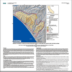 
The objective of this report is to present a preliminary emergency assessment of the potential for debris-flow generation from basins burned by the Ammo Fire in San Diego County, southern California in 2007. Debris flows are among the most hazardous geologic phenomena; debris flows that followed wildfires in southern California in 2003 killed 16 people and caused tens of millions of dollars of property damage. A short period of even moderate rainfall on a burned watershed can lead to debris flows. Rainfall that is normally absorbed into hillslope soils can run off almost instantly after vegetation has been removed by wildfire. This causes much greater and more rapid runoff than is normal from creeks and drainage areas. Highly erodible soils in a burn scar allow flood waters to entrain large amounts of ash, mud, boulders, and unburned vegetation. Within the burned area and downstream, the force of rushing water, soil, and rock can destroy culverts, bridges, roadways, and buildings, potentially causing injury or death. This emergency debris-flow hazard assessment is presented as relative ranking of the predicted median volume of debris flows that can issue from basin outlets in response to 1.75 inches (44.45 mm) of rainfall over a 3-hour period. Such a storm has a 10-year return period. The calculation of debris flow volume is based on a multiple-regression statistical model that describes the median volume of material that can be expected from a recently burned basin as a function of the area burned at high and moderate severity, the basin area with slopes greater than or equal to 30 percent, and triggering storm rainfall. Cannon and others (2007) describe the methods used to generate the hazard maps. Identification of potential debris-flow hazards from burned drainage basins is necessary to issue warnings for specific basins, to make effective mitigation decisions, and to help plan evacuation timing and routes. |
Version 1.0 Posted December 2007 |
Cannon, S.H., Gartner, J.E., Michael, J.A., Bauer, M.A., Stitt, S.C., Knifong, D.L., McNamara, B.J., and Roque, Y.M., 2007, Emergency assessment of debris-flow hazards from basins burned by the 2007 Ammo Fire, San Diego County, southern California: U.S. Geological Survey Open-File Report 2007–1413, 1 sheet.

![]() U.S. Department of the Interior | U.S. Geological Survey
U.S. Department of the Interior | U.S. Geological Survey
URL: http://pubsdata.usgs.gov/pubs/of/2007/1413/index.html
Questions or Assistance: Contact USGS
Last modified: Wednesday, 07-Dec-2016 20:27:30 EST
