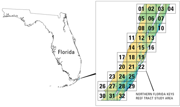
USGS-NPS-NASA EAARL Submarine Topography

LIDAR Illustration

Home Button

Purpose Button

PDF Maps Button

Raw Data Button

Link to ArcMap Documnet

Metadata Button

Collaborators Button


PDF Map Index - Submarine Topography


To view a Lidar map as a PDF file, select the appropriate link using either the map or from the geographic locationlisted below. These maps were designed to be printed at 34x44", but can be scaled, within the printer dialog window, to fit smaller page sizes.

Click on a tile number (1-32) in the map below to view the corresponding map tile as a PDF file.

To expedite download times and to prevent any possible errors, right click on the desired PDF map tile and save the file to disk. If you require all of the map tiles or would like a copy of the Open-File Report in DVD format, please contact: Emily Klipp in the USGS, FISC St. Petersburg office: eklipp@usgs.gov


Northern Florida Keys Reef Tract Tile Map Tile 1Tile 2Tile 3Tile 4Tile 7Tile 6Tile 5Tile 10Tile 9Tile 8Tile 13Tile 12Tile 11Tile 16Tile 15Tile 14Tile 17Tile 18Tile 19Tile 20Tile 21Tile 22Tile 23Tile 24Tile 25Tile 29Tile 28Tile 27Tile 26Tile 32Tile 31Tile 30


  • Island Topography

To view a tile as a PDF file, download a free copy of Adobe Reader:     Get Adobe Reader

Accessibility FOIA Privacy Policies and Notices

Take Pride in America home pageFirstGov LinkU.S. Department of the Interior | U.S. Geological Survey
URL: http://pubsdata.usgs.gov/pubs/of/2007/1432/HTML/pdf_maps.html
For more information, contact: Feedback
Maintained by Publishing Service Center
Page Last Modified: Wednesday, 07-Dec-2016 20:49:43 EST