Open-File Report 2008-1004
Sea-Floor Character and Sedimentary Processes in the Vicinity of Woods Hole, Massachusetts
![]() Title | Abstract | Introduction | Setting | Methods | Bathymetry and Backscatter | Seismic Profiles | Character and Processes | Data Catalog | Acknowledgments | References | Figures | Bottom Photography | Sediment Data | Contacts
Title | Abstract | Introduction | Setting | Methods | Bathymetry and Backscatter | Seismic Profiles | Character and Processes | Data Catalog | Acknowledgments | References | Figures | Bottom Photography | Sediment Data | Contacts
 |
||
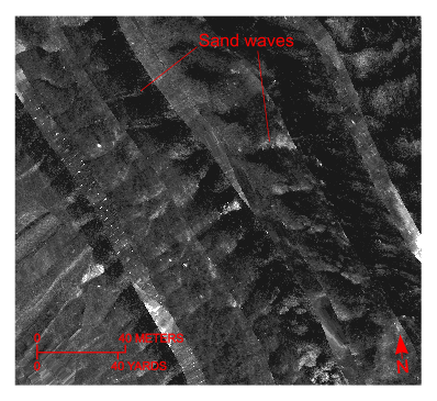
Figure 28. Detailed planar view of the sidescan-sonar mosaic produced during National Oceanic and Atmospheric Administration survey H11077 of Woods Hole, Massachusetts, showing relatively straight to sinuous alternating bands of high and low backscatter (“tiger-stripe”) pattern indicative of transverse sand waves. Location of view, which is in the channel west of Great Ledge, is shown in figure 19. | ||

![]() U.S. Department of the Interior |
U.S. Geological Survey
U.S. Department of the Interior |
U.S. Geological Survey
URL: http://pubsdata.usgs.gov/pubs/of/2008/1004/html/fig28.html
Page Contact Information: GS Pubs Web Contact
Page Last Modified: Tuesday, 10-Dec-2024 16:30:06 EST