Open-File Report 2008-1004
Sea-Floor Character and Sedimentary Processes in the Vicinity of Woods Hole, Massachusetts
![]() Title | Abstract | Introduction | Setting | Methods | Bathymetry and Backscatter | Seismic Profiles | Character and Processes | Data Catalog | Acknowledgments | References | Figures | Bottom Photography | Sediment Data | Contacts
Title | Abstract | Introduction | Setting | Methods | Bathymetry and Backscatter | Seismic Profiles | Character and Processes | Data Catalog | Acknowledgments | References | Figures | Bottom Photography | Sediment Data | Contacts
 |
||
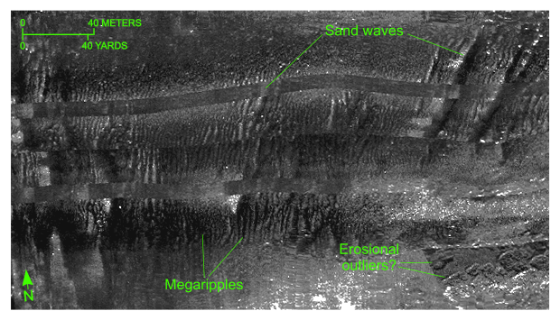
Figure 42. Detailed planar view along the southern edge of the sidescan-sonar mosaic produced during National Oceanic and Atmospheric Administration survey H11077 of Woods Hole, Massachusetts, showing relatively straight to sinuous alternating bands of high and low backscatter (“tiger-stripe”) pattern indicative of transverse sand waves. Note the abundance of megaripples between and on the stoss slopes of the waves indicative of active transport, and that the crest orientation of the sand waves and megaripples does not always match. Location of view is shown in figure 19. | ||

![]() U.S. Department of the Interior |
U.S. Geological Survey
U.S. Department of the Interior |
U.S. Geological Survey
URL: http://pubsdata.usgs.gov/pubs/of/2008/1004/html/fig42.html
Page Contact Information: GS Pubs Web Contact
Page Last Modified: Tuesday, 10-Dec-2024 16:49:46 EST