Open-File Report 2008-1004
Sea-Floor Character and Sedimentary Processes in the Vicinity of Woods Hole, Massachusetts
![]() Title | Abstract | Introduction | Setting | Methods | Bathymetry and Backscatter | Seismic Profiles | Character and Processes | Data Catalog | Acknowledgments | References | Figures | Bottom Photography | Sediment Data | Contacts
Title | Abstract | Introduction | Setting | Methods | Bathymetry and Backscatter | Seismic Profiles | Character and Processes | Data Catalog | Acknowledgments | References | Figures | Bottom Photography | Sediment Data | Contacts
 |
||
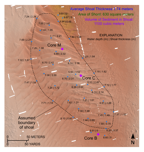
Figure 56. Detailed planar view of the shoal west of Great Ledge. Image shows the extent of the shoal (dashed lines) and vibracore stations. Numbers separated by vertical lines show mean lower low water depth and thickness of the shoal above the surrounding sea floor, respectively. Location of view is shown in figure 19. | ||

![]() U.S. Department of the Interior |
U.S. Geological Survey
U.S. Department of the Interior |
U.S. Geological Survey
URL: http://pubsdata.usgs.gov/pubs/of/2008/1004/html/fig56.html
Page Contact Information: GS Pubs Web Contact
Page Last Modified: Tuesday, 10-Dec-2024 16:59:38 EST