
Open-File Report 2008-1146
Interpolation of Reconnaissance Multibeam and Single-Beam Bathymetry Offshore of Milford, Connecticut
![]() Title |
Introduction |
Methods |
Reconnaissance Bathymetry |
Interpolated Bathymetry |
GIS Data Catalog |
Acknowledgments |
References |
List of Figures |
Contacts
Title |
Introduction |
Methods |
Reconnaissance Bathymetry |
Interpolated Bathymetry |
GIS Data Catalog |
Acknowledgments |
References |
List of Figures |
Contacts
 |
||
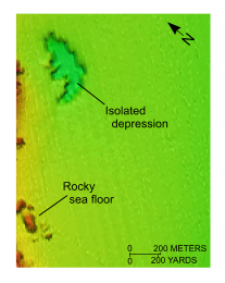
Figure 10. Detailed view of the interpolated bathymetry from the northern part of National Oceanic and Atmospheric Administration survey H11044. Image shows the rocky nature of the nearshore sea floor and one of the isolated depressions of unknown origin. Location of view is shown in figure 2. | ||

![]() U.S. Department of the Interior |
U.S. Geological Survey
U.S. Department of the Interior |
U.S. Geological Survey
URL: http://pubsdata.usgs.gov/pubs/of/2008/1146/html/fig10.html
Page Contact Information: GS Pubs Web Contact
Page Last Modified: Thursday, 23-Jan-2025 14:37:20 EST


