
Open-File Report 2008-1174
Enhanced Sidescan-Sonar Imagery, North-Central Long Island Sound
![]() Title |
Introduction |
Data Acquisition |
Processing of Sidescan Sonar |
GIS Data Catalog |
Acknowledgments |
References |
Figures |
Contacts
Title |
Introduction |
Data Acquisition |
Processing of Sidescan Sonar |
GIS Data Catalog |
Acknowledgments |
References |
Figures |
Contacts
 |
||
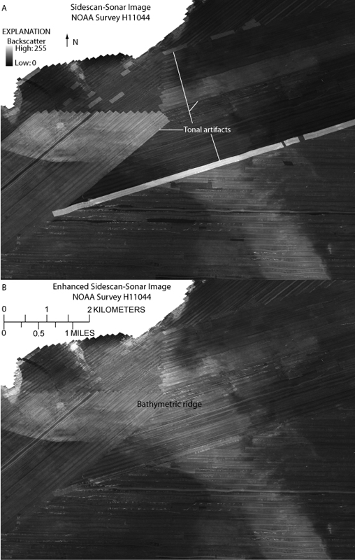
Figure 5. Detailed image of (A) sidescan-sonar imagery from National Oceanic and Atmospheric Administration survey H11044 and (B) enhanced imagery. The backscatter tones in groups of adjacent lines were matched to surrounding backscatter tones, as were tones of individual lines and segments. The high backscatter associated with an elongated bathymetric ridge is more easily delineated in the enhanced imagery. Lighter tones represent higher backscatter, and darker tones represent lower backscatter. Locations of images shown in fig. 4. | ||

![]() U.S. Department of the Interior |
U.S. Geological Survey
U.S. Department of the Interior |
U.S. Geological Survey
URL: http://pubsdata.usgs.gov/pubs/of/2008/1174/html/fig5.html
Page Contact Information: GS Pubs Web Contact
Page Last Modified: Wednesday, 11-Dec-2024 15:27:37 EST


