McMullen, K.Y., 2009, H11322ENVIRONS: Interpretation of the Sedimentary Environments of National Oceanic and Atmospheric Administration (NOAA) Survey H11322, Western Rhode Island Sound (Geographic): Open-File Report 2008-1181, U.S. Geological Survey, Coastal and Marine Geology Program, Woods Hole Science Center, Woods Hole, MA.This is part of the following larger work.Online Links:
- <http://pubs.usgs.gov/of/2008/1181/data/interpretation/h11322environs/h11322environs.zip>
- <http://pubs.usgs.gov/of/2008/1181/html/catalog.html>
McMullen, K.Y., Poppe, L.J., Haupt, T.A., and Crocker, J.M., 2009, Sidescan-Sonar Imagery and Surficial Geologic Interpretations of the Sea Floor in Western Rhode Island Sound: Open-File Report 2008-1181, U.S. Geological Survey, Coastal and Marine Geology Program, Woods Hole Science Center, Woods Hole, MA.Online Links:
This is a Vector data set. It contains the following vector data types (SDTS terminology):
Horizontal positions are specified in geographic coordinates, that is, latitude and longitude. Latitudes are given to the nearest 0.000001. Longitudes are given to the nearest 0.000001. Latitude and longitude values are specified in Decimal degrees.
The horizontal datum used is D_WGS_1984.
The ellipsoid used is WGS_1984.
The semi-major axis of the ellipsoid used is 6378137.000000.
The flattening of the ellipsoid used is 1/298.257224.
Sequential unique whole numbers that are automatically generated.
Coordinates defining the features.
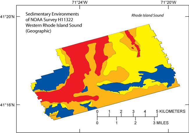
| Value | Definition |
|---|---|
| Erosion | erosion or nondeposition characterized by high backscatter in the sidescan-sonar image and clusters of boulders indicating coarser grained sediment reflective of higher energy environments |
| Sort_rework | sorting and reworking characterized by moderate backscatter in the sidescan-sonar imagery and the sea floor tends to be relatively smooth |
| Cgbt | Coarse-grained bedload transport characterized by bathymetric highs and where there are sand waves |
| Deposition | fine-grained deposition characterized by low backscatter in the sidescan-sonar imagery and typically occurring in part of the channel and bathymetric lows |
(508) 548-8700 X2277 (voice)
(508) 457-2310 (FAX)
kmcmullen@usgs.gov
This data layer is a component of the H11322 Survey, GIS database and represents an interpretation of the sidescan-sonar mosaic for the study area. The interpretation can be used as an overlay for the mosaic image and shows the sedimentary environments of the study area such as erosion or nondeposition, sorting and reworking, deposition, and coarse-grained bedload transport.
U.S. Geological Survey, and National Oceanographic and Atmospheric Administration, 2008, h11322_1m_sss_geo_str.tif.
U.S. Geological Survey, and National Oceanic and Atmospheric Administration, 2008, h11322_geo.tif.
Person who carried out this activity:
(508) 548-8700 x2277 (voice)
(508) 457-2310 (FAX)
kmcmullen@usgs.gov
Data sources produced in this process:
Person who carried out this activity:
(508) 548-8700 x2277 (voice)
(508) 457-2310 (FAX)
kmcmullen@usgs.gov
Data sources produced in this process:
Person who carried out this activity:
(508) 548-8700 x2277 (voice)
(508) 457-2310 (FAX)
kmcmullen@usgs.gov
Data sources produced in this process:
McMullen, K.Y., Poppe, L.J., Twomey, E.R., Danforth, W.W., Haupt, T.A., and Crocker, J.M., 2007, Sidescan-Sonar Imagery, Multibeam Bathymetry, and Surficial Geologic Interpretations of the Sea Floor in Rhode Island Sound, off Sakonnet Point, Rhode Island: Open-File Report 2007-1150, U.S. Geological Survey, Coastal and Marine Geology Program, Woods Hole Science Center, Woods Hole, MA.Online Links:
McMullen, K.Y., Poppe, L.J., Denny, J.F., Haupt, T.A., and Crocker, J.M., 2008, Sidescan-Sonar Imagery and Surficial Geologic Interpretations of the Sea Floor in Central Rhode Island Sound: Open-File Report 2007-1366, U.S. Geological Survey, Coastal and Marine Geology Program, Woods Hole Science Center, Woods Hole, MA.Online Links:
Attributes have been visually checked by the compilers.
Navigation was by differential GPS.
Layer is complete as interpreted for these features.
Several shapefiles representing various features identified on the mosaic were combined to create this data layer. The layers were edited and processed in a consistent manner.
Are there legal restrictions on access or use of the data?
- Access_Constraints: None
- Use_Constraints:
- Public domain data are freely redistributable with proper metadata and source attribution. Please recognize the U.S. Geological Survey as the originator of this dataset.
(508) 548-8700 x2314 (voice)
(508) 457-2310 (FAX)
lpoppe@usgs.gov
Downloadable Data: Sedimentary environments of NOAA Survey H11322 in Rhode Island Sound
Neither the U.S. Government, the Department of the Interior, nor the USGS, nor any of their employees, contractors, or subcontractors, make any warranty, express or implied, nor assume any legal liability or responsibility for the accuracy, completeness, or usefulness of any information, apparatus, product, or process disclosed, nor represent that its use would not infringe on privately owned rights. The act of distribution shall not constitute any such warranty, and no responsibility is assumed by the USGS in the use of these data or related materials.
| Data format: | The SHP file contains the geospatial data. The SHX file contains the index of the geospatial data. The DBF file contains the attribute data in dBase format. The PRJ file contains the coordinate system information. The SBN and SBX files contain the spatial index of the geospatial data (optional). The XML file contains the metadata describing the data set <data set name>.shp.xml. Three other forms of the metadata are also available: FGDC html, FAQ html, and ASCII text. In addtion a browse graphic showing the data layer coverage and extent is included. in format SHP ESRI Shapefile Size: 0.093 |
|---|---|
| Network links: |
<http://pubs.usgs.gov/of/2008/1181/data/interpretation/h11322environs/h11322environs.zip> <http://pubs.usgs.gov/of/2008/1181/html/catalog.html> |
| Media you can order: |
DVD-ROM
(Density 4.75
Gbytes)
(format UDF)
|
These data are available in Environmental Systems Research Institute (ESRI) shapefile format. The user must have ArcGIS or ArcView 3.0 or greater software to read and process the data file. In lieu of ArcView or ArcGIS, the user may utilize another GIS application package capable of importing the data. A free data viewer, ArcExplorer, capable of displaying the data is available from ESRI at www.esri.com.
(508) 548-8700 x2277 (voice)
(508) 457-2310 (FAX)
kmcmullen@usgs.gov