Open-File Report 2008-1181
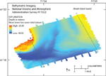
The study area consists of bathymetric highs, located in the northwest, southwest, and northeast, and a system of elongate, interconnected bathymetric lows that deepen southward and westward (fig. 6). The lows trend toward the southwest between the northern highs and toward the west in the south. The northwestern high is the shallowest part of the study area, with depths as shallow as 25 m. The northeastern high, where depths are as shallow as 29 m, contains a shallow depression about 35 m deep that is oriented north-northwest to south-southeast. The southwestern part of the channel system, where depths reach as much as 40 m, is the deepest part of the study area. |

![]() U.S. Department of the Interior |
U.S. Geological Survey
U.S. Department of the Interior |
U.S. Geological Survey
URL: http://pubsdata.usgs.gov/pubs/of/2008/1181/html/bathy.html
Page Contact Information: GS Pubs Web Contact
Page Last Modified: Friday, 26-Aug-2022 08:34:21 EDT