USGS Open-File Report 2008-1257
By Susan J. Tewalt, Scott A. Kinney, and Matthew D. Merrill
2008
Worldwide coal consumption and international coal trade are projected to increase in the next several decades (Energy Information Administration, 2007). A search of existing literature indicates that in the Western Hemisphere, coal resources are known to occur in about 30 countries. The need exists to be able to depict these areas in a digital format for use in Geographic Information System (GIS) applications at small scales (large areas) and in visual presentations.
Existing surficial geology GIS layers of the appropriate geologic age have been used as an approximation to depict the extent of coal-bearing areas in North, Central, and South America, as well as Greenland (fig. 1). Global surficial geology GIS data were created by the U.S. Geological Survey (USGS) for use in world petroleum assessments (Hearn and others, 2003). These USGS publications served as the major sources for the selection and creation of polygons to represent coal-bearing areas. Additional publications and maps by various countries and agencies were also used as sources of coal locations. GIS geologic polygons were truncated where literature or hardcopy maps did not indicate the presence of coal.
The depicted areas are not adequate for use in coal resource calculations, as they were not adjusted for geologic structure and do not include coal at depth. Additionally, some coal areas in Central America could not be represented by the mapped surficial geology and are shown only as points based on descriptions or depictions from scientific publications or available maps. The provided GIS files are intended to serve as a backdrop for display of coal information. Three attributes of the coal that are represented by the polygons or points include geologic age (or range of ages), published rank (or range of ranks), and information source (published sources for age, rank, or physical location, or GIS geology base).
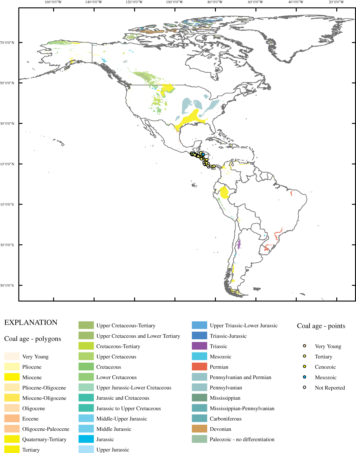
Figure 1. Map of coal-bearing areas of North, Central, and South America, including the island of Greenland. Colors are representative of coal age and are based on those adopted by the International Commission on Stratigraphy (International Commission on Stratigraphy, 2008). [Click on image to open larger version in new window.]
The data were compiled in ArcGIS version 9.2 (Environmental Systems Research Institute, Inc, ESRI). The downloadable files have been compressed with WinZip and may be extracted with WinZip on Microsoft Windows operating systems. The ".zip" downloadable file includes data, metadata, and projection parameters. Metadata are provided in text format and as an associated file with the spatial data. Polygon features are shapefiles in geographic coordinates (decimal degrees) with horizontal datum WGS84.
To view the Americas coal dataset, download the Americas_coal.zip file (compressed 13.7 MB, uncompressed 20 MB) and unzip with WinZip or Microsoft Windows. The file Americas_coalply.shp contains all polygonal features for coal-bearing areas in the Americas. The file Central_American_coalpt.shp contains all point features for coal-bearing locations in Central America that cannot be represented by the geologic polygon. Metadata for the Americas_coalply.shp are viewable using ArcCatalog and as a separate text file (americas_coal.txt); all details regarding these data are explained in the metadata. The file Americas_coal.mxd can be viewed with the licensed product ArcGIS version 9.2 (ESRI). Americas_coal.pmf can be viewed with ArcReader (ESRI) which may be downloaded without charge from http://www.esri.com/software/arcgis/arcreader. Americas_coalply.kmz and Central_America_coalpt.kmz are viewable in Google Earth, another spatial viewing program available for free download.
Data are not intended for use in resource assessments at any scale, but are best used for graphical display at scales smaller than 1:5,000,000.
Neither the U.S. Government, the Department of the Interior, nor the U.S. Geological Survey, nor any of their employees, contractors, or subcontractors, make any warranty, express or implied, nor assume any legal liability or responsibility for the accuracy, completeness, or usefulness of any information, apparatus, product, or process disclosed, nor represent that its use would not infringe on privately owned rights. Although these data have been processed successfully on a computer system at the U.S. Geological Survey, no warranty expressed or implied is made regarding the display or utility of the data on any other system, or for general or scientific purposes, nor shall the act of distribution constitute any such warranty. The U.S. Geological Survey shall not be held liable for improper or incorrect use of the data described and/or contained herein.
This GIS compilation is likely to be superseded in the future if new improved information becomes available or if additional effort is invested in refining the method of depicting coal-bearing areas.
Numerous publications were consulted, but a limited number were selected to serve as the source of information for this GIS data. A full listing of published sources is in the metadata file that accompanies this GIS. Peter D. Warwick and Laura R.H. Biewick of the USGS are thanked for their insightful reviews of this GIS data layer.
Energy Information Administration, 2007, International Energy Outlook 2007: Energy Information Administration, accessed online September 10, 2007, at http://www.eia.doe.gov/oiaf/ieo/world.html.
Hearn, P., Jr., Hare, T., Schruben, P., Sherrill, D., LaMar, C., and Tsushima, P., 2003, Global GIS - Global Coverage DVD (1st ed.): American Geological Institute, 1 DVD.
International Commission on Stratigraphy, 2008, International Stratigraphic Chart: International Commission on Stratigraphy, accessed online April, 8, 2008, at http://www.stratigraphy.org.
Tewalt, S.J., Kinney, S.A., and Merrill, M.D., 2008, GIS representation of coal-bearing areas in North, Central, and South America: U.S. Geological Survey Open-File Report 2008-1257, available online at https://pubs.usgs.gov/of/2008/1257/.

![]() U.S. Department of the Interior | U.S. Geological Survey
U.S. Department of the Interior | U.S. Geological Survey
URL: pubsdata.usgs.gov/pubs/of/2008/1257/index.html
Page Contact Information: Matthew D. Merrill
Page Last Modified: August 25, 2008