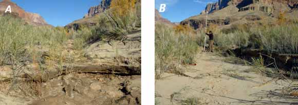
The south gully mouth viewed from the terminus at the Colorado River. A, The clay lens knickpoint as it appeared on November 20, 2004. B, Deposition in the gully bottom and erosion of the southern margin of the gully wall. USGS photograph by Amy Draut (from figure 7).
This study examines a large drainage network incised into alluvial terraces located along the Colorado River downstream of Palisades Creek in Grand Canyon National Park, Ariz. Gully erosion in the drainage affects archaeological sites found on the wide, relatively flat alluvial terraces. In 1996, 7-d release of 1,274 cubic meters per second of water from Glen Canyon Dam, known as a controlled flood, deposited fine-grained sediment—sand, silt, and clay—in the mouth of the network’s largest gully, informally known as south gully. The deposit persisted for several years, but the drainage network steepened in the downstream reaches between 1999 and 2004. A high-flow experiment similar to the 1996 controlled flood was conducted in November 2004. The 2004 experiment was of a lower magnitude and shorter duration compared to the 1996 controlled flood. Topographic surveys were made in the field before, immediately after, and 6 months following the November 2004 experiment, and these measurements were compared to those made in 1996 and in other years. Similar to the response in 1996, fine-grained sediment was deposited in the mouth of the south gully and this mass was largely retained during the 6 months following the 2004 event. The magnitude of deposition in 2004 was nearly two times greater than that resulting from the 1996 controlled flood. We attribute this marked difference to increased accommodation space for deposition in the gully mouth, which was more deeply eroded in 2004 than it was in 1996. The second of the two primary gullies found within the Palisades gully network, the north gully, was largely unaffected by either high flow. Between 1996 and 2005, erosion was primarily confined to the lower reach of the south gully, while the upper reach remained relatively stable. The available data suggest that local base-level changes in the south gully mouth were not linked to the stability of the upstream gully reach. It could not be determined whether temporary base-level increases or maintenance of erosion-control structures were causal factors in limiting erosion in the upstream reaches of the drainage network.
Download this report as a 22-page PDF file (of2008-1264.pdf; 1.5 MB)
For questions about the content of this report, contact Joe Hazel (Joseph.Hazel@nau.edu) or Helen Fairley (hfairley@usgs.gov).
Download the Suggested citation and version history
Download a free copy of the latest version of Adobe Reader.
|
Help |
PDF help |
Publications main page |
| Western Open-File Reports for 2008 |
| Biological Resources |
Southwest Biological Science Center
|
This report is available only on the Web

![]() U.S. Department of the Interior | U.S. Geological Survey
U.S. Department of the Interior | U.S. Geological Survey
URL: https://pubs.usgs.gov/of/2008/1264/
Page Contact Information: Michael Diggles
Page Created: September 2, 2008