Earthquake Hazards Program
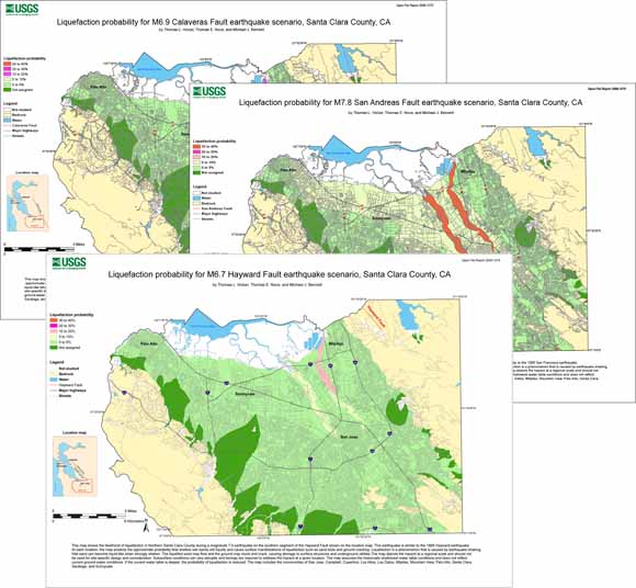
Maps showing the probability of surface manifestations of liquefaction in the northern Santa Clara Valley were prepared with liquefaction probability curves. The area includes the communities of San Jose, Campbell, Cupertino, Los Altos, Los Gatos Milpitas, Mountain View, Palo Alto, Santa Clara, Saratoga, and Sunnyvale. The probability curves were based on complementary cumulative frequency distributions of the liquefaction potential index (LPI) for surficial geologic units in the study area. LPI values were computed with extensive cone penetration test soundings. Maps were developed for three earthquake scenarios, an M7.8 on the San Andreas Fault comparable to the 1906 event, an M6.7 on the Hayward Fault comparable to the 1868 event, and an M6.9 on the Calaveras Fault. Ground motions were estimated with the Boore and Atkinson (2008) attenuation relation. Liquefaction is predicted for all three events in young Holocene levee deposits along the major creeks. Liquefaction probabilities are highest for the M7.8 earthquake, ranging from 0.33 to 0.37 if a 1.5-m deep water table is assumed, and 0.10 to 0.14 if a 5-m deep water table is assumed. Liquefaction probabilities of the other surficial geologic units are less than 0.05. Probabilities for the scenario earthquakes are generally consistent with observations during historical earthquakes.
Files for viewing the three earthquake scenario liquefaction hazard maps at full scale are linked below. The plots are approximately 29 x 40 inches in size.
Download the map for the San Andreas Fault as a PDF file (of2008-1270_San_Andreas_scenario.pdf; 1.7 MB).
Download the map for the Hayward Fault as a PDF file (of2008-1270_Hayward_scenario.pdf; 1.8 MB).
Download the map for the CalaverasFault as a PDF file (of2008-1270_Calaveras_scenario.pdf; 1.7 MB).
Download the technical report as a 32-page PDF file (of2008-1270_technical_report.pdf; 1.4 MB).
A zipped file containing the .kmz Google Earth file for the three earthquake scenario liquefaction scenario maps is linked below. Opening this file will launch Google Earth and zoom in on the study area. You can open the Places tool, go to the Temporary Places folder, and open the Liquefaction Scenarios For Santa Clara County line so you can turn layers on and off. The three Liquefaction Scenarios are shown as choices; click on them one at a time or in combination to view the study results.
Download the Google Earth .kmz file (of2008-1270_kmz.zip; 1.1 MB).
View the Readme file that explains the files in this report (of2008-1270_readme.txt; 56 kB).
View the metadata file which is a Federal Geographic Data Committee (FGDC) compliant metadata file derived from the digital database (of2008-1270_metadata.txt; 72 kB).
Download the GIS data package. This is a zipped file containing all of the shapefiles (.shp) of faults, liquefaction probability polygons, water bodies, major highways, streets, surficial geologic units, study area boundary, layer files, location maps used in the creation of all three earthquake scenario liquefaction hazard maps. Also included are the Map Document Files (.mxd) used to open them in ArcMap, and the Published Map Files (.pmf) used to open them in ArcReader. (of2008-1270_shapefiles.zip; 5.5 MB).
Obtain the cone penetration testing (CPT) data that were used to develop the liquefaction probability curves.
California Geological Survey regulatory Seismic Hazard Zone Program maps—you can locate special study zones mandated by the State of California or download Data.
For questions about this report, contact Tom Holzer.
Suggested citation and version history
Download a free copy of the latest version of Adobe Reader.
| Help | Publications main page | Western Open-File Reports for 2008 |
| Geology | Earthquake Hazards Program |
This report is available only on the Web

![]() U.S. Department of the Interior | U.S. Geological Survey
U.S. Department of the Interior | U.S. Geological Survey
URL: https://pubs.usgs.gov/of/2008/1270/
Page Contact Information: Michael Diggles
Page Created: September 12, 2008
Page Last Modified: November 25, 2008
(mfd)