Geographic Analysis and Monitoring Program
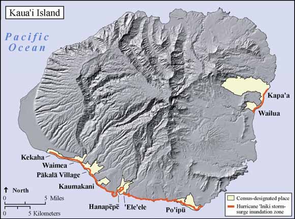
Map of Kaua‘i Island, Hawai‘i, including census-designated places that intersect the historical storm-surge inundation zones from 1992 Hurricane ‘Iniki (from figure 1).
The Pacific Risk Management ‘Ohana (PRiMO) is a network of partners and stakeholders involved in the development, delivery, and communication of risk management-related information, products, and services across the Pacific Ocean (National Oceanic and Atmospheric Administration Pacific Services Center, 2008). One PRiMO-related project is the NOAA National Climatic Data Center’s Integrated Data and Environmental Applications (IDEA) Center’s Pacific Region Integrated Climatology Information Products (PRICIP) initiative, which seeks to improve the understanding of patterns and trends of storm frequency and intensity (ÒstorminessÓ) within the Pacific region and to develop a suite of integrated information products that can be used by emergency managers, mitigation planners, government agencies, and other decision-makers (National Oceanic and Atmospheric Administration Integrated Data and Environmental Applications Center, 2008a).
One of the PRICIP information products is a historical storm Òevent anatomy,Ó which includes a summary of sector-specific socioeconomic impacts associated with a particular event, as well as information about the event and its climatological context. The intent of an event anatomy is to convey the causes of an extreme storm event and the associated impacts in a format that users can understand. The event anatomies also are intended to familiarize users with the in-place and remotely sensed products typically employed to track and forecast weather and climate. The first event anatomy developed as a prototype and hosted on the PRICIP portal is for Hurricane ‘Iniki (National Oceanic and Atmospheric Administration Integrated Data and Environmental Applications Center, 2008b), a Category 3-4 hurricane that made landfall on the south coast of Kaua‘i Island on September 11, 1992, with estimated maximum sustained winds of more than 140 mph and gusts as high as 175 mph. Storm-surge inundation occurred on the southern and northeastern coast of Kaua‘i Island.
In an effort to increase the amount of available information on the Hurricane ‘Iniki event anatomy of the PRICIP portal, representatives from the NOAA NCDC IDEA Center contacted the U.S. Geological Survey (USGS) in 2007 for assistance in determining what current societal assets are in areas that were inundated by storm surge during Hurricane ‘Iniki in 1992. This report contains data summarizing the amount and percentage of current societal assets on Kaua‘i Island, Hawai‘i, that exist in the historic Hurricane ‘Iniki storm-surge inundation zone. Coupled with an array of information on the socioeconomic impacts of Hurricane ‘Iniki and distributed through the PRICIP portal, the results of this effort will help managers and the general public to understand the current risks posed by extreme storms in the Pacific Basin.
Abstract 1. Map of Kaua‘i Island, including census-designated places that intersect the historical storm-surge inundation zones from 1992 Hurricane ‘Iniki 1. Amount (acres) and percentage of land classified as developed within the 1992 Hurricane ‘Iniki storm-surge inundation zone, Kaua‘i Island, Hawai‘i. Send questions or comments about this report to the author, Nate Wood, (360) 993-8951.
Suggested citation and version history
Download a free copy of the latest version of Adobe Reader. |
Help |
PDF help |
Publications main page |
This report is available only on the Web
Introduction
Methods
Results
Acknowledgments
References Cited
Figures
2. Amount (acres) and percentage of developed land within the 1992 Hurricane ‘Iniki storm-surge inundation zone, Kaua‘i Island, Hawai‘i, based on 2001 NOAA C-CAP land-cover data
3. Number and percentage of residents currently within the 1992 Hurricane ‘Iniki storm-surge inundation zone, Kaua‘i Island, Hawai‘i
4. Number and percentage of employees within the 1992 Hurricane ‘Iniki storm-surge inundation zone, Kaua‘i Island, Hawai‘i
5. Percentage of employees, by business sector, currently in the 1992 Hurricane ‘Iniki storm-surge inundation zone, Kaua‘i Island, Hawai‘i
6. Current amount, in dollars, and percentage of total tax parcel value (minus exemptions) within the 1992 Hurricane ‘Iniki storm-surge inundation zone, Kaua‘i Island, Hawai‘i
7. Sum of normalized factors for both the amount and percentage of various assets for each community with land in the 1992 Hurricane ‘Iniki storm-surge inundation zone, Kaua‘i Island, Hawai‘i
Tables
2. Number and percentage of residents currently within the 1992 Hurricane ‘Iniki storm-surge inundation zone, Kaua‘i Island, Hawai‘i.
3. Amount and percentage of current economic assets within the 1992 Hurricane ‘Iniki storm-surge inundation zone, Kaua‘i Island, Hawai‘i.
4. Distribution of employees, by business sector, within the 1992 Hurricane ‘Iniki storm-surge inundation zone, Kaua‘i Island, Hawai‘i.
Download this report as a 15-page PDF (of2008-1280.pdf, 872 kB)
| Western Open-File Reports for 2008 |
| Geography |
Western Geographic Science Center
|

![]() U.S. Department of the Interior | U.S. Geological Survey
U.S. Department of the Interior | U.S. Geological Survey
URL: https://pubs.usgs.gov/of/2008/1280/
Page Contact Information: Michael Diggles
Page Created: September 8, 2008 (mfd)
Page Last Modified: September 8, 2008 (mfd)