Geophysical Unit of Menlo Park, Calif.
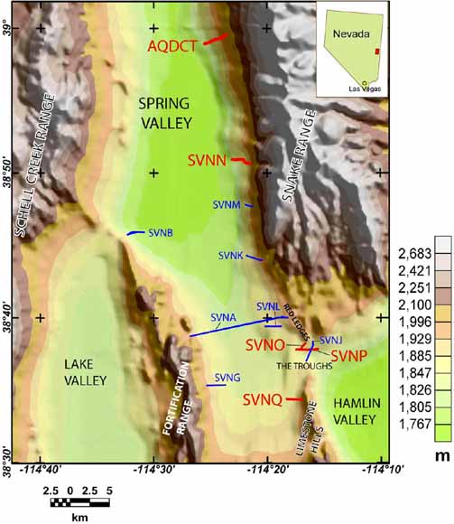
Topographic map of southern Spring Valley, Nev., showing location of
audiomagnetotelluric profiles in red. Profiles shown in blue were collected prior to May
2007 and are presented in McPhee and others, 2006, 2007 (from figure 1)
This report presents audiomagnetotelluric (AMT) data along fourteen profiles in Spring, Delamar, and Dry Lake Valleys, and the corresponding preliminary two-dimensional (2-D) inverse models. The AMT method is a valuable tool for estimating the electrical resistivity of the Earth over depth ranges from a few meters to less than one kilometer, and it is important for revealing subsurface structure and stratigraphy within the Basin and Range province of eastern Nevada, which can be used to define the geohydrologic framework of the region. We collected AMT data by using the Geometrics StrataGem EH4 system. Profiles were 0.7 - 3.2 km in length with station spacing of 50-400 m. Data were recorded in a coordinate system parallel to and perpendicular to the regional geologic-strike direction with Z positive down. We show AMT station locations, sounding curves of apparent resistivity, phase, and coherency, and 2-D models of subsurface resistivity along the profiles. The 2-D inverse models are computed from the transverse electric (TE), transverse magnetic (TM), and TE+TM mode data by using a conjugate gradient, finite-difference method. Preliminary interpretation of the 2-D models defines the structural framework of the basins and the resistivity contrasts between alluvial basin-fill, volcanic units, and carbonate basement rocks.
Download the text of this report as a 59-page PDF file (of2008-1301_text.pdf; 4.7 MB).
Download Appendix A of this report as a 44-page PDF file. This file consists of the sounding curves (of2008-1301_appendix_a.pdf; 4.3 MB).
For questions about the content of this report, contact Darcy McPhee
Suggested citation and version history
Download a free copy of the latest version of Adobe Reader.
|
Help |
PDF help |
Publications main page |
| Western Open-File Reports for 2008 |
| Geologic Division |
Geophysical Unit of Menlo Park, Calif. (GUMP)
|

![]() U.S. Department of the Interior | U.S. Geological Survey
U.S. Department of the Interior | U.S. Geological Survey
URL: https://pubs.usgs.gov/of/2008/1301/
Page Contact Information: Michael Diggles
Page Created: September 29, 2008
Page Last Modified: October 1, 2008
(mfd)