Geographic Analysis and Monitoring Program
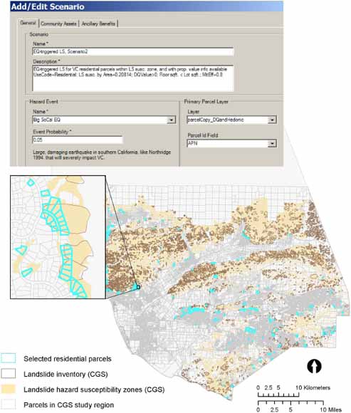
The Land Use Portfolio Model and Ventura County, showing residential parcels selected for a hypothetical mitigation action, California Geological Survey (CGS) preliminary landslide inventory, CGS landslide-hazard susceptibility zones, and parcels in the CGS study region (from figure 2).
With costs of natural disasters skyrocketing and populations increasingly settling in areas vulnerable to natural hazards, society is challenged to better allocate its limited risk-reduction resources. In 2000, Congress passed the Disaster Mitigation Act, amending the Robert T. Stafford Disaster Relief and Emergency Assistance Act (Robert T. Stafford Disaster Relief and Emergency Assistance Act, Pub. L. 93-288, 1988; Federal Emergency Management Agency, 2002, 2008b; Disaster Mitigation Act, 2000), mandating that State, local, and tribal communities prepare natural-hazard mitigation plans to qualify for pre-disaster mitigation grants and post-disaster aid. The Federal Emergency Management Agency (FEMA) was assigned to coordinate and implement hazard-mitigation programs, and it published information about specific mitigation-plan requirements and the mechanisms (through the Hazard Mitigation Grant ProgramHMGP) for distributing funds (Federal Emergency Management Agency, 2002). FEMA requires that each community develop a mitigation strategy outlining long-term goals to reduce natural-hazard vulnerability, mitigation objectives and specific actions to reduce the impacts of natural hazards, and an implementation plan for those actions. The implementation plan should explain methods for prioritizing, implementing, and administering the actions, along with a “cost-benefit review” justifying the prioritization.
FEMA, along with the National Institute of Building Sciences (NIBS), supported the development of HAZUS (“Hazards U.S.”), a geospatial natural-hazards loss-estimation tool, to help communities quantify potential losses and to aid in the selection and prioritization of mitigation actions. HAZUS was expanded to a multiple-hazard version, HAZUS-MH, that combines population, building, and natural-hazard science and economic data and models to estimate physical damages, replacement costs, and business interruption for specific natural-hazard scenarios. HAZUS-MH currently performs analyses for earthquakes, floods, and hurricane wind.
HAZUS-MH loss estimates, however, do not account for some uncertainties associated with the specific natural-hazard scenarios, such as the likelihood of occurrence within a particular time horizon or the effectiveness of alternative risk-reduction options. Because of the uncertainties involved, it is challenging to make informative decisions about how to cost-effectively reduce risk from natural-hazard events. Risk analysis is one approach that decision-makers can use to evaluate alternative risk-reduction choices when outcomes are unknown. The Land Use Portfolio Model (LUPM), developed by the U.S. Geological Survey (USGS), is a geospatial scenario-based tool that incorporates hazard-event uncertainties to support risk analysis. The LUPM offers an approach to estimate and compare risks and returns from investments in risk-reduction measures. This paper describes and demonstrates a hypothetical application of the LUPM for Ventura County, California, and examines the challenges involved in developing decision tools that provide quantitative methods to estimate losses and analyze risk from natural hazards.
Download text of this report as a 15-page PDF file (of2008-1309.pdf; 1.6 MB)
For questions about the content of this report, contact Lori Dinitz.
Suggested citation and version history
Download a free copy of the latest version of Adobe Reader.
|
Help |
PDF help |
Publications main page |
| Western Open-File Reports for 2008 |
| Geography | Geographic Analysis and Monitoring Program
|

![]() U.S. Department of the Interior | U.S. Geological Survey
U.S. Department of the Interior | U.S. Geological Survey
URL: https://pubs.usgs.gov/of/2008/1309/
Page Contact Information: Michael Diggles
Page Created: September 30, 2008
Page Last Modified: September 30, 2008