Southwest Geographic Science Center
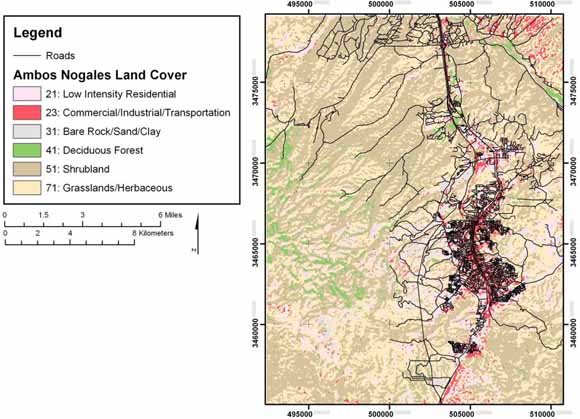
Final binational land-cover map of Ambos Nogales, Arizona, United States, and Sonora, Mexico, for input to AGWA2 (from figure 17).
The Ambos Nogales watershed, which surrounds the twin cities of Nogales, Arizona, United States and Nogales, Sonora, Mexico, has a history of problems related to flooding. This paper describes the process of creating a high-resolution, binational land-cover dataset to be used in modeling the Ambos Nogales watershed. The Automated Geospatial Watershed Assessment tool will be used to model the Ambos Nogales watershed to identify focal points for planning efforts and to anticipate ramifications of implementing detention reservoirs at certain watershed planes.
Download this report as a 42-page PDF file (of2008-1378.pdf; 3.6 MB).
Download the land-use-cover GIS data as a compressed .zip file (of2008-1378_landuse.zip; 40 kB compressed file that opens into a 160-kB folder).
For questions about the content of this report, contact Laura Norman.
Suggested citation and version history
Download a free copy of the latest version of Adobe Reader.
|
Help |
PDF help |
Publications main page |
| Western Open-File Reports for 2008 |
| Geography | Western Region Geography
|

![]() U.S. Department of the Interior | U.S. Geological Survey
U.S. Department of the Interior | U.S. Geological Survey
URL: https://pubs.usgs.gov/of/2008/1378/
Page Contact Information: Michael Diggles
Page Created: January 26, 2009
Page Last Modified: March 13, 2009
(mfd)