U.S. Geological Survey, 2009, H11346_BCHANNELS.SHP: Interpreted Distribution of the Axes of Fluvially-Cut Late Pleistocene Channels Buried Beneath Edgartown Harbor, Massachusetts, in Geographic, WGS84: Open-File Report 2009-1001, U.S. Geological Survey, Coastal and Marine Geology Program, Woods Hole Coastal and Marine Science Center, Woods Hole, MA.This is part of the following larger work.Online Links:
- <https://pubs.usgs.gov/of/2009/1001/data/interpret/bchannels/h11346_bchannels.zip>
- <https://pubs.usgs.gov/of/2009/1001/html/catalog.html>
Poppe, L.J., McMullen, K.Y., Foster, D.S., Blackwood, D.S., Williams, S.J., Ackerman, S.D., Moser, M.S., and Glomb, K.A., 2010, Geological Interpretation of the Sea Floor Offshore of Edgartown, Massachusetts: Open-File Report 2009-1001, U.S. Geological Survey, Coastal and Marine Geology Program, Woods Hole Coastal and Marine Science Center, Woods Hole, MA.Online Links:
This is a Vector data set. It contains the following vector data types (SDTS terminology):
Horizontal positions are specified in geographic coordinates, that is, latitude and longitude. Latitudes are given to the nearest 0.000001. Longitudes are given to the nearest 0.000001. Latitude and longitude values are specified in Decimal degrees.
The horizontal datum used is D_WGS_1984.
The ellipsoid used is WGS_1984.
The semi-major axis of the ellipsoid used is 6378137.000000.
The flattening of the ellipsoid used is 1/298.257224.
Sequential unique whole numbers that are automatically generated.
Coordinates defining the features.
508-548-8700 x2314 (voice)
508-457-2310 (FAX)
[email protected]
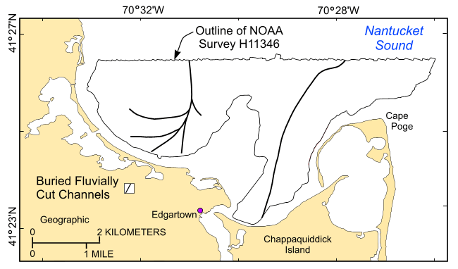
To release a data layer showing the interpreted distribution of the axes of fluvially-cut late Pleistocene channels buried within the NOAA survey H11346 area based on seismic data collected during USGS survey RAFA08034 in Edgartown Harbor, Massachusetts, in a geographic, WGS84 coordinate system.
Person who carried out this activity:
508-548-8700 x2314 (voice)
508-457-2310 (FAX)
[email protected]
Data sources produced in this process:
Person who carried out this activity:
508-548-8700 x2314 (voice)
508-457-2310 (FAX)
[email protected]
Data sources produced in this process:
Poppe, L.J., Ackerman, S.D., Foster, D.S., Blackwood, D.S., Butman, B., Moser, M.S., and Stewart, H.F., 2007, Sea-floor character and sedimentary processes of Quicks Hole, Elizabeth Islands, Massachusetts: Open-File Report 2006-1357, U.S. Geological Survey, Coastal and Marine Geology Program, Woods Hole Coastal and Marine Science Center, Woods Hole, MA.Online Links:
Poppe, L.J., Ackerman, S.D., Foster, D.S., Blackwood, D.S., Williams, S.J., Moser, M.S., Stewart, H.F., and Glomb, K.A., 2007, Sea-floor character and sedimentary processes of Great Round Shoal Channel, offshore Massachusetts: Open-File Report 2007-1138, U.S. Geological Survey, Coastal and Marine Geology Program, Woods Hole Coastal and Marine Science Center, Woods Hole, MA.Online Links:
Poppe, L.J., McMullen, K.Y., Foster, D.S., Blackwood, D.S., Williams, S.J., Ackerman, S.D., Barnum, S.R., and Brennan, R.T., 2008, Sea-floor character and sedimentary processes in the vicinity of Woods Hole, Massachusetts: Open-File Report 2008-1004, U.S. Geological Survey, Coastal and Marine Geology Program, Woods Hole Coastal and Marine Science Center, Woods Hole, MA.Online Links:
Navigation was by differential GPS. Ship's antenna was offset form the Chirp system by less than 5 m and from Boomer system by less than 20 m. Interpretation good to 1:24,000.
All collected data were processed and used to produce this dataset.
No additional checks for consistency were performed on this data.
Are there legal restrictions on access or use of the data?
- Access_Constraints: None
- Use_Constraints:
- The interpretation was completed at map scales less than 1:10,000, and is not intended for use smaller map scales. Public domain data from the U.S. Government are freely redistributable with proper metadata and source attribution. Please recognize the U.S. Geological Survey (USGS) as the source of this information.
508-548-8700 x2314 (voice)
508-457-2310 (FAX)
[email protected]
Downloadable Data
Neither the U.S. Government, the Department of the Interior, nor the USGS, nor the National Oceanic and Atmospheric Administration (NOAA), nor any of their employees, contractors, or subcontractors, make any warranty, express or implied, nor assume any legal liability or responsibility for the accuracy, completeness, or usefulness of any information, apparatus, product, or process disclosed, nor represent that its use would not infringe on privately owned rights. The act of distribution shall not constitute any such warranty, and no responsibility is assumed by the USGS or NOAA in the use of these data or related materials. Any use of trade, product, or firm names is for descriptive purposes only and does not imply endorsement by the U.S. Government.
| Data format: | A zip file containing the geospatial data, metadata, and browse graphic. in format SHP (version 3.3) ESRI line shapefile Size: 0.160 |
|---|---|
| Network links: | <https://pubs.usgs.gov/of/2009/1001/data/interpret/bchannels/h11346_bchannels.zip> <https://pubs.usgs.gov/of/2009/1001/data/interpret/bchannels/> <https://pubs.usgs.gov/of/2009/1001/html/catalog.html> |
| Media you can order: | DVD-ROM (Density 4.75 Gbytes) (format UDF) |
The user must be capable of uncompressing WinZip files. Also, these data are available in Environmental Systems Research Institute (ESRI) shapefile format. The user must have ArcGIS or ArcView 3.0 or greater software to read and process the data file. In lieu of ArcView or ArcGIS, the user may utilize another GIS application package capable of importing data. A free data viewer, ArcExplorer, capable of displaying the data is available from ESRI at www.esri.com.
508-548-8700 x2314 (voice)
508-457-2310 (FAX)
[email protected]