08034_KELNAVLINE.SHP: Line Navigation for the Chirp High-Resolution Seismic-Reflection Profiles Collected During U.S. Geological Survey (USGS) R/V Rafael Cruise 08034 off Edgartown, Massachusetts

Metadata also available as [Outline] - [Parseable text]

Frequently-anticipated questions:


What does this data set describe?

Title:
08034_KELNAVLINE.SHP: Line Navigation for the Chirp High-Resolution Seismic-Reflection Profiles Collected During U.S. Geological Survey (USGS) R/V Rafael Cruise 08034 off Edgartown, Massachusetts
Abstract:
The U.S. Geological Survey (USGS), in cooperation with the National Oceanic and Atmospheric Administration (NOAA) and the Massachusetts Office of Coastal Zone Management (MA CZM), is producing detailed geologic maps of the coastal sea floor. Imagery, originally collected by NOAA for charting purposes, provides a fundamental framework for research and management activities along this part of the Massachusetts coastline, shows the composition and terrain of the seabed, and provides information on sediment transport and benthic habitat. Interpretive data layers were derived from the combined single-beam and multibeam echo-sounder data and sidescan-sonar data collected in the vicinity of Edgartown Harbor, Massachusetts. During August 2008 seismic-reflection profiles (Boomer and Chirp) were acquired, and during September 2008 bottom photographs and surficial sediment data were acquired as part of two ground-truth reconnaissance surveys.
  1. How should this data set be cited?

    Poppe, Larry, 2009, 08034_KELNAVLINE.SHP: Line Navigation for the Chirp High-Resolution Seismic-Reflection Profiles Collected During U.S. Geological Survey (USGS) R/V Rafael Cruise 08034 off Edgartown, Massachusetts: Open-File Report 2009-1001, U.S. Geological Survey, Coastal and Marine Geology Program, USGS Woods Hole Coastal and Marine Science Center, Woods Hole, MA.

    Online Links:

    This is part of the following larger work.

    Poppe, L.J., McMullen, K.Y., Foster, D.S., Blackwood, D.S., Williams, S.J., Ackerman, S.D., Moser, M.S., and Glomb, K.A., 2010, Geological Interpretation of the Sea Floor Offshore of Edgartown, Massachusetts: Open-File Report 2009-1001, U.S. Geological Survey, Coastal and Marine Geology Program, USGS Woods Hole Coastal and Marine Science Center, Woods Hole, MA.

    Online Links:

  2. What geographic area does the data set cover?

    West_Bounding_Coordinate: -70.550201
    East_Bounding_Coordinate: -70.432541
    North_Bounding_Coordinate: 41.444981
    South_Bounding_Coordinate: 41.385845

  3. What does it look like?

    <https://pubs.usgs.gov/of/2009/1001/data/seismic/kel/lines/08034_kelnavline.gif> (GIF)
    Browse graphic showing location of Chirp high-resolution seismic-reflection profile lines collected during RV Rafael cruise 08034.

  4. Does the data set describe conditions during a particular time period?

    Beginning_Date: 19-Aug-2008
    Ending_Date: 20-Aug-2008
    Currentness_Reference: ground condition

  5. What is the general form of this data set?

    Geospatial_Data_Presentation_Form: vector digital data

  6. How does the data set represent geographic features?

    1. How are geographic features stored in the data set?

      This is a Vector data set. It contains the following vector data types (SDTS terminology):

      • String (16)

    2. What coordinate system is used to represent geographic features?

      Horizontal positions are specified in geographic coordinates, that is, latitude and longitude. Latitudes are given to the nearest 0.000001. Longitudes are given to the nearest 0.000001. Latitude and longitude values are specified in Decimal degrees.

      The horizontal datum used is D_WGS_1984.
      The ellipsoid used is WGS_1984.
      The semi-major axis of the ellipsoid used is 6378137.000000.
      The flattening of the ellipsoid used is 1/298.257224.

      Vertical_Coordinate_System_Definition:
      Depth_System_Definition:
      Depth_Datum_Name: Local surface
      Depth_Resolution: 0.001
      Depth_Distance_Units: milliseconds
      Depth_Encoding_Method: Implicit coordinate

  7. How does the data set describe geographic features?

    08034_kelnavline
    Shapefile (Source: ESRI)

    FID
    Internal feature number. (Source: ESRI)

    Sequential unique whole numbers that are automatically generated.

    Shape
    Feature geometry. (Source: ESRI)

    Coordinates defining the features.

    Line
    Line designation (Source: Scientist)

    Character field

    Id
    Internal feature (Source: ESRI)

    Image
    File name for the JPEG image of KEL Chirp profile. (Source: Processor)

    Character field

    Entity_and_Attribute_Overview:
    This dataset contains the line navigation for the Chirp seismic reflection profiles collected during cruise 08034.


Who produced the data set?

  1. Who are the originators of the data set? (may include formal authors, digital compilers, and editors)

  2. Who also contributed to the data set?

  3. To whom should users address questions about the data?

    Larry Poppe
    U.S. Geological Survey
    Geologist
    384 Woods Hole Road
    Woods Hole, MA 02543
    USA

    508-548-8700 x2314 (voice)
    508-457-2310 (FAX)
    lpoppe@usgs.gov


Why was the data set created?

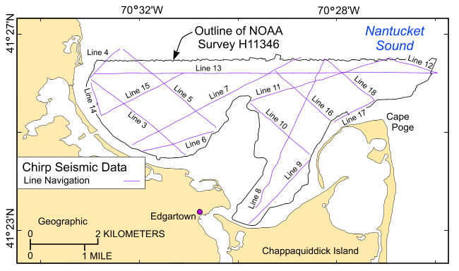
To release a polyline data set for the Chirp seismic-reflection data collected along five lines in the vicinity of Edgartown Harbor, offshore Massachusetts. The Chirp data were collected to interpret the shallower stratigraphy beneath Edgartown Harbor.


How was the data set created?

  1. From what previous works were the data drawn?

    (source 1 of 1)
    U.S. Geological Survey, Unpublished Material, 08034 Chirp line navigation.

    Type_of_Source_Media: disc
    Source_Contribution: The original Chirp navigation data.

  2. How were the data generated, processed, and modified?

    Date: 19-Aug-2008 (process 1 of 6)
    High-resolution 3.5 kHz Chirp data were collected August 19-20 aboard the Research Vessel Rafael. The Chirp data were acquired digitally along 16 lines totaling approximately 56.1 km with a Knudsen Engineering Limited (KEL) Chirp 3200 shallow water system and KEL SounderSuite v1.26 software. The Chirp trace data recorded with a ping rate of 0.5 seconds for 66 ms with a sample rate of 0.048 ms in standard SEG-Y format.

    Person who carried out this activity:

    David Foster
    U.S. Geological Survey
    Geologist
    384 Woods Hole Road
    Woods Hole, MA 02543
    USA

    508-548-8700 x2271 (voice)
    508-457-2310 (FAX)
    dfoster@usgs.gov

    Date: 10-Dec-2008 (process 2 of 6)
    The raw SEG-Y data were read into Promax R2003 processing software. Heave compensation data from the Teledyne TSS sensor (mounted on the transducer sidemount pole) were extracted from the SEG-Y headers and were used to apply a static shift to the trace data. A topmute above the sea floor was digitized and applied. An AGC with a window length of 5 ms was applied. The processed data were written to a new SEG-Y file.

    Person who carried out this activity:

    David Foster
    U.S. Geological Survey
    Geologist
    384 Woods Hole Road
    Woods Hole, MA 02543
    USA

    508-548-8700 x2271 (voice)
    508-457-2310 (FAX)
    dfoster@usgs.gov

    Date: 10-Dec-2008 (process 3 of 6)
    A Unix shell script was run that used Seismic Unix to read the processed SEG-Y files and extract shot number, horizontal position, year, day, and time of day from the headers. AWK was used to parse the ASCII data, add line and image name fields, and convert position in seconds of arc to decimal degrees. The ASCII file was filtered using Linux "sort" to keep only the unique horizontal positions output to a comma delimited file.

    Person who carried out this activity:

    David Foster
    U.S. Geological Survey
    Geologist
    384 Woods Hole Road
    Woods Hole, MA 02543

    508-548-8700 x2271 (voice)
    508-457-2310 (FAX)
    dfoster@usgs.gov

    Data sources produced in this process:
    • 08034_kelnav.txt

    Date: 19-Aug-2009 (process 4 of 6)
    The comma delimited file was edited with Vi to add a field called "Image". The field contains the path and JPEG file name of the KEL Chirp profile.

    Person who carried out this activity:

    David Foster
    U.S. Geological Survey
    Geologist
    384 Woods Hole Road
    Woods Hole, Woods Hole 02543

    508-548-8700 x2271 (voice)
    508-457-2310 (FAX)
    dfoster@usgs.gov

    Data sources used in this process:
    • 08034_kelnav.txt

    Data sources produced in this process:

    • 08034_kelnav.txt

    Date: 19-Aug-2009 (process 5 of 6)
    The ASCII comma delimited shot point navigation data were imported and converted to a shapefile using the create feature class using X-Y table in ArcCatalog 9.2 and the coordinate system and datum were defined as geographic, WGS84.

    Person who carried out this activity:

    David Foster
    U.S. Geological Survey
    Geologist
    384 Woods Hole Road
    Woods Hole, MA 02543

    508-548-8700 x2271 (voice)
    508-457-2310 (FAX)
    dfoster@usgs.gov

    Data sources used in this process:
    • 08034_kelnav.txt

    Data sources produced in this process:

    • 08034_kelnav.shp

    Date: 19-Aug-2009 (process 6 of 6)
    Unique shot points were converted to lines using VAC Extras 1.97, convert points to line verrsion 2.0 (a local toolset) within ArcMap 9.2.

    Person who carried out this activity:

    David Foster
    U.S. Geological Survey
    Geologist
    384 Woods Hole Road
    Woods Hole, MA 02543
    USA

    508-548-8700 x2271 (voice)
    508-457-2310 (FAX)
    dfoster@usgs.gov

    Data sources used in this process:
    • 08034_kelnav.shp

    Data sources produced in this process:

    • 08034_kelnavline.shp

  3. What similar or related data should the user be aware of?

    O'Hara, C.J., and Oldale, R.N., 1987, Maps showing the geology, shallow structure, and bedform morphology of Nantucket Sound, Massachusetts: Miscellaneous Field Studies Map MF-1911, U.S. Geological Survey, Coastal and Marine Geology Program, Woods Hole Coastal and Marine Science Center, Woods Hole, MA.

    Poppe, L.J., McMullen, K.Y., Foster, D.S., Blackwood, D.S., Williams, S.J., Ackerman, S.D., Barnum, S.R., and Brennan, R.T., 2008, Sea-floor character and sedimentary processes in the vicinity of Woods Hole, Massachusetts: Open-File Report 2008-1004, U.S. Geological Survey, Coastal and Marine Geology Program, Woods Hole Coastal and Marine Science Center, Woods Hole, MA.

    Online Links:


How reliable are the data; what problems remain in the data set?

  1. How well have the observations been checked?

    All attributes were checked in a consistent manner.

  2. How accurate are the geographic locations?

    Horizontal_Positional_Accuracy_Report: Navigation was by DGPS; positional accuracy to less than 10 m. The 3.5 kHz transducer was mounted on a pole on the starboard side of the RV Rafael 0.6 m below the water surface.

  3. How accurate are the heights or depths?

    The vertical position was local sea level and there have been no corrections to a datum or for tidal variations. A draft of 0.6 meters was applied to account for the transducer depth.

  4. Where are the gaps in the data? What is missing?

    All available trackline data along Chirp seismic acquisition lines collected during the RV Rafael cruise 08034 is included in this data set except for the first two files were omitted from the processing. These files only contain a few seconds of data.

  5. How consistent are the relationships among the observations, including topology?

    No additional checks for consistency were performed on this data.


How can someone get a copy of the data set?

Are there legal restrictions on access or use of the data?

Access_Constraints: None
Use_Constraints:
Public domain data from the U.S. Government are freely redistributable with proper metadata and source attribution. Please recognize the U.S. Geological Survey (USGS) as the source of this information.

  1. Who distributes the data set? (Distributor 1 of 1)

    Larry Poppe
    U.S. Geological Survey
    Geologist
    384 Woods Hole Road
    Woods Hole, MA 02543
    USA

    508-548-8700 x2314 (voice)
    508-457-2310 (FAX)
    lpoppe@usgs.gov

  2. What's the catalog number I need to order this data set?

    Downloadable Data

  3. What legal disclaimers am I supposed to read?

    Neither the U.S. Government, the Department of the Interior, nor the USGS, nor the National Oceanic and Atmospheric Administration (NOAA), nor any of their employees, contractors, or subcontractors, make any warranty, express or implied, nor assume any legal liability or responsibility for the accuracy, completeness, or usefulness of any information, apparatus, product, or process disclosed, nor represent that its use would not infringe on privately owned rights. The act of distribution shall not constitute any such warranty, and no responsibility is assumed by the USGS or NOAA in the use of these data or related materials. Any use of trade, product, or firm names is for descriptive purposes only and does not imply endorsement by the U.S. Government.

  4. How can I download or order the data?

  5. What hardware or software do I need in order to use the data set?

    These data are available in Environmental Systems Research Institute (ESRI) shapefile format. The user must have ArcGIS or ArcView 3.0 or greater software to read and process the data file. In lieu of ArcView or ArcGIS, the user may utilize another GIS application package capable of importing data. A free data viewer, ArcExplorer, capable of displaying the data is available from ESRI at www.esri.com. The user must have software capable of uncompressing archived zip files, such as WinZip or Pkware.


Who wrote the metadata?

Dates:
Last modified: 31-Aug-2009
Metadata author:
David Foster
U.S. Geological Survey
Geologist
384 Woods Hole Road
Woods Hole, MA 02543
USA

508-548-8700 x2271 (voice)
508-457-2310 (FAX)
dfoster@usgs.gov

Metadata standard:
FGDC Content Standards for Digital Geospatial Metadata (FGDC-STD-001-1998)
Metadata extensions used:


Generated by mp version 2.9.6 on Mon Aug 31 14:14:00 2009