U.S. Geological Survey, 2009, A80_6LINES2.SHP: Ship Tracklines for Seismic-Reflection Data Collected in Southern Rhode Island Sound in 1980: Open-File Report 2009-1003, U.S. Geological Survey, Coastal and Marine Geology Program, Woods Hole Science Center, Woods Hole, MA.This is part of the following larger work.Online Links:
- <https://pubs.usgs.gov/of/2009/1003/data/nav/sris/a80_6lines/a80_6lines.zip>
- <https://pubs.usgs.gov/of/2009/1003/html/catalog.html>
McMullen, K.Y., Poppe, L.J., and Soderberg, N.K., 2009, Digital Seismic-Reflection Data from Eastern Rhode Island Sound and Vicinity, 1975-1980: Open-File Report 2009-1003, U.S. Geological Survey, Coastal and Marine Geology Program, Woods Hole Science Center, Woods Hole, MA.Online Links:
This is a Vector data set. It contains the following vector data types (SDTS terminology):
Horizontal positions are specified in geographic coordinates, that is, latitude and longitude. Latitudes are given to the nearest 0.000001. Longitudes are given to the nearest 0.000001. Latitude and longitude values are specified in Decimal degrees.
The horizontal datum used is D_WGS_1984.
The ellipsoid used is WGS_1984.
The semi-major axis of the ellipsoid used is 6378137.000000.
The flattening of the ellipsoid used is 1/298.257224.
| Range of values | |
|---|---|
| Minimum: | 6/10/1980 |
| Maximum: | 6/12/1980 |
Coordinates defining the features.
Sequential unique whole numbers that are automatically generated.
Coordinates defining the features.
| Value | Definition |
|---|---|
| seismic line identification |
| Value | Definition |
|---|---|
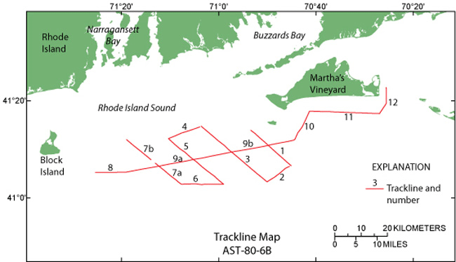
| AST-80-6B |
Location of the image file
(508) 548-8700 x2277 (voice)
(508) 457-2310 (FAX)
kmcmullen@usgs.gov
This GIS layer contains tracklines of the ship-track navigation collected aboard the R/V Asterias during a 1980 geophysical cruise in southern Rhode Island Sound. It is a polyline shapefile that corresponds to a80_6nav_sort.shp and the black and white TIFF images. It is part of a digital version of a regional map showing the distribution of sub-bottom seismic profiles collected in Rhode Island Sound. The seismic data collected along these ship tracks can be used to provide useful information about the framework geology in this region.
O'Hara, C., Eusden, J., and Whitney, A., 1980, Geophysics Log, Asterias 80-6B, Southern Rhode Island Sound.Online Links:
Person who carried out this activity:
(508) 548-8700 x2277 (voice)
(508) 457-2310 (FAX)
kmcmullen@usgs.gov
Data sources produced in this process:
O'Hara, C.J., and Oldale, R.N., 1980, Maps showing geology and shallow structure of eastern Rhode Island Sound and Vineyard Sound, Massachusetts: Miscellaneous Field Studies Map MF-1186, U.S. Geological Survey, Coastal and Marine Geology Program, Woods Hole Science Center, Woods Hole, MA.
McMullen, K.Y., Poppe, L.J., and Soderberg, N.K., 2009, Digital Seismic-Reflection Data from Western Rhode Island Sound, 1980: Open-File Report 2009-1002, U.S. Geological Survey, Coastal and Marine Geology Program, Woods Hole Science Center, Woods Hole, MA.Online Links:
Attribute data were recorded by the science party and entered and checked by the compilers in a consistent manner.
All navigation was done by LORAN-C and was manually recorded. The cruise used the Group Repetition Interval 9960 Northeast U.S. chain and recorded time delays from Caribou, Maine (W) and Carolina Beach, N.C. (Y) slave transmitters. Absolute accuracy is 185 to 463 m based on <http://www.navcen.uscg.gov/loran/handbook/h-book.htm> (see Chapter III).
Complete information is provided for all navigation lines in the data set. Navigation points are spaced at approximately 15-minute intervals and at course changes or line events (start/end of line). Continuous navigation is not available.
The layers were edited and processed in a consistent manner.
Are there legal restrictions on access or use of the data?
- Access_Constraints: None
- Use_Constraints:
- Public domain data are freely redistributable with proper metadata and source attribution. Please recognize the U.S. Geological Survey as the originator of this dataset.
(508) 548-8700 x2314 (voice)
(508) 457-2310 (FAX)
lpoppe@usgs.gov
Downloadable Data: a80_6lines2.shp
Neither the U.S. Government, the Department of the Interior, nor the USGS, nor any of their employees, contractors, or subcontractors, make any warranty, express or implied, nor assume any legal liability or responsibility for the accuracy, completeness, or usefulness of any information, apparatus, product, or process disclosed, nor represent that its use would not infringe on privately owned rights. The act of distribution shall not constitute any such warranty, and no responsibility is assumed by the USGS in the use of these data or related materials. Any use of trade, product, or firm names is for descriptive purposes only and does not imply endorsement by the U.S. Government.
| Data format: | The SHP file contains the geospatial data. The SHX file contains the index of the geospatial data. The DBF file contains the attribute data in dBase format. The PRJ file contains the coordinate system information. The SBN and SBX files contain the spatial index of the geospatial data (optional). The XML file contains the metadata describing the data set <data set name>.shp.xml. Three other forms of the metadata are also available: FGDC html, FAQ html, and ASCII text. In addition a browse graphic showing the data layer coverage and extent is included. in format SHP ESRI Shapefile Size: 0.003 |
|---|---|
| Network links: |
<https://pubs.usgs.gov/of/2009/1003/data/nav/sris/a80_6lines/a80_6lines.zip> <https://pubs.usgs.gov/of/2009/1003/html/catalog.html> |
| Media you can order: |
DVD-ROM
(Density 4.75
Gbytes)
(format UDF)
|
These data are available in Environmental Systems Research Institute (ESRI) shapefile format. The user must have ArcGIS or ArcView 3.0 or greater software to read and process the data file. In lieu of ArcView or ArcGIS, the user may utilize another GIS application package capable of importing the data. A free data viewer, ArcExplorer, capable of displaying the data is available from ESRI at www.esri.com. The user must be able to uncompress a WinZip 9.0 file.
(508) 548-8700 x2277 (voice)
(508) 457-2310 (FAX)
kmcmullen@usgs.gov