DH_SEABOSS_Photos: Bottom photographs (JPEG format) collected by the U.S. Geological Survey offshore of Massachusetts between Duxbury and Hull.

Metadata also available as - [Outline] - [Parseable text]

Frequently-anticipated questions:


What does this data set describe?

Title:
DH_SEABOSS_Photos: Bottom photographs (JPEG format) collected by the U.S. Geological Survey offshore of Massachusetts between Duxbury and Hull.
Abstract:
These data were collected under a cooperative agreement with the Massachusetts Office of Coastal Zone Management (CZM) and the U.S. Geological Survey (USGS), Coastal and Marine Geology Program, Woods Hole Science Center (WHSC). Initiated in 2003, the primary objective of this program is to develop regional geologic framework information for the management of coastal and marine resources. Accurate data and maps of sea-floor geology are important first steps toward protecting fish habitat, delineating marine resources, and assessing environmental changes due to natural or human impacts. The project is focused on the inshore waters (5-30 m deep) of Massachusetts between the New Hampshire border and Cape Cod Bay. Data collected for the mapping cooperative have been released in a series of USGS Open-File Reports (<http://woodshole.er.usgs.gov/project-pages/coastal_mass/html/current_map.html>). This spatial dataset is from the study area located between Duxbury and Hull Massachusetts, and consists of high-resolution geophysics (bathymetry, backscatter intensity, and seismic reflection) and ground validation (sediment samples, video tracklines and bottom photographs). The data were collected during four separate surveys conducted between 2003 and 2007 (NOAA survey H10993 in 2003, USGS-WHSC survey 06012 in 2006, and USGS-WHSC surveys 07001 and 07003 in 2007) and cover more than 200 square kilometers of the inner continental shelf.
  1. How should this data set be cited?

    U.S. Geological Survey, 2010, DH_SEABOSS_Photos: Bottom photographs (JPEG format) collected by the U.S. Geological Survey offshore of Massachusetts between Duxbury and Hull.: Open-File Report 2009-1072, U.S. Geological Survey, Coastal and Marine Geology Program, Woods Hole Science Center, Woods Hole, Massachusetts.

    Online Links:

    This is part of the following larger work.

    Barnhardt, Walter A. , Ackerman, Seth D. , Andrews, Brian D. , and Baldwin, Wayne E. , 2010, Geophysical and Sampling Data from the Inner Continental Shelf: Duxbury to Hull, Massachusetts.: Open-File Report 2009-1072, U.S. Geological Survey, Coastal and Marine Geology Program, Woods Hole Science Center, Woods Hole, Massachusetts.

    Online Links:

  2. What geographic area does the data set cover?

    West_Bounding_Coordinate: -70.815622
    East_Bounding_Coordinate: -70.598329
    North_Bounding_Coordinate: 42.329661
    South_Bounding_Coordinate: 42.088155

  3. What does it look like?

    <https://pubs.usgs.gov/of/2009/1072/GIS/browse_jpg/big/DH_BottomPhotographs.jpg> (JPEG)
    JPEG image of the seafloor

  4. Does the data set describe conditions during a particular time period?

    Beginning_Date: 08-Sep-2007
    Ending_Date: 10-Sep-2007
    Currentness_Reference: ground condition

  5. What is the general form of this data set?

    Geospatial_Data_Presentation_Form: raster digital data

  6. How does the data set represent geographic features?

    1. How are geographic features stored in the data set?

      This is a Raster data set.

    2. What coordinate system is used to represent geographic features?

  7. How does the data set describe geographic features?


Who produced the data set?

  1. Who are the originators of the data set? (may include formal authors, digital compilers, and editors)

  2. Who also contributed to the data set?

  3. To whom should users address questions about the data?

    Seth Ackerman
    U.S. Geological Survey
    Geologist
    384 Woods Hole Rd.
    Woods Hole, MA 02543-1598
    USA

    508-548-8700 x2315 (voice)
    508-457-2310 (FAX)
    sackerman@usgs.gov


Why was the data set created?

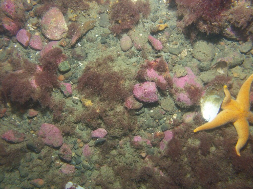
This data set includes the bottom photographs acquired with the large SEABed Observation and Sampling System (SEABOSS) during USGS survey 07003, conducted September 7-11, 2007 aboard the R/V Connecticut offshore Massachusetts in the Duxbury to Hull survey area. This data set was collected to ground-truth (verify) the acoustic data sets that were acquired during NOAA hydrographic survey H10993 (2003) and USGS geophysical surveys 06012 (2006) and 07001 (2007). The locations of these bottom photos can be found in the shapefile DH_BottomPhotos.shp. Bottom video were also taken at each station occupied by the SEABOSS (see shapefile DH_SeaBossTrackline.shp)


How was the data set created?

  1. From what previous works were the data drawn?

    (source 1 of 1)
    Source_Contribution:
    The SEABed Observation and Sampling System (SEABOSS) was designed by the U.S. Geological Survey (USGS) for rapid and effective collection of seabed images and sediment samples in coastal regions. The observations from video and still cameras and the sediment data are used to explore the nature of the seafloor and, in conjunction with high-resolution geophysical data, to make interpretive maps of sedimentary environments and validate the acoustic remote sensing data. The SEABOSS is a simple system that can be deployed from both small and large surface vessels and operates in water depths up to 200m. It incorporates two video cameras, a still camera, a depth sensor, and a modified Van Veen sediment sampler. The elements of this particular SEABOSS system are held within a stainless steel framework that measures 1.2 x 1.2 meters and weighs 136 kilograms overall. The frame has a stabilizer fin that orients the system as it drifts over the seabed. The digital camera, a Minolta DiMAGE A2, is mounted in a machined Delrin housing with a flat port and is set for 3264x2448 pixel images at the "fine" setting for compression. This allows the camera to be used for over 200 images with a 1 GB Compact Flash card without downloading. The system also has a PHOTOSEA strobe. Two lasers are set 20 cm apart (both as they are mounted on the SEABOSS frame and as seen in photographs and video on the seabed) for scale measurements. The red laser dots can usually be seen in the photo depending on the bottom type and the distance to the sea floor. A third laser is positioned at an angle so that when it intersects the other lasers, the SEABOSS is at the optimum height (approximately 75 cm) off the bottom for a still photograph. The camera is set to a manual focus and set to a default focus distance once the camera is powered up. The default focus distance is slightly less than the optimum height above the seafloor to account for optical distortion under water. All of the system's elements are powered from the surface vessel through a conducting cable. The winch operator views a video monitor so that the system can be maintained at an appropriate height above the bottom and obstacles can be avoided. Scientists also view video monitors and decide when to sample and take still photographs. Video displays include station number, water depth (from the depth sensor), and date, time, and geographic position (provided by a shipboard navigation system). The SEABOSS was deployed from the R/V Connecticut off the ship's J-frame on the starboard side. The vessel occupied one of the target stations and deployed the SEABOSS. The winch operator lowered the sampler until the seafloor was observed in the real-time bottom video. On most stations, the vessel and sampler drifted with wind and current for approximately 5-15 minutes. The SEABOSS operator monitored the real-time bottom video and acquired still bottom photographs at points of interest by remotely triggering the camera shutter. The number of photographs per station varied from 4-20 depending on the complexity of the bottom. The third laser on the system was set to an angle such that the optimum photograph height was 75 cm. The default focus on the camera was set to 50 cm. The imaged area is most often within 0.5 to 1.25 meters from left to right. Other camera settings are as follows: aperture is set at f/8; shutter speed is 1/125 second. The camera time during this survey was set to EDT, unless otherwise noted (see metadata for DH_BottomPhotos.shp (<https://pubs.usgs.gov/of/2009/1072/html/appendix1.html>) for details on when the time value was wrong and how it was corrected).

  2. How were the data generated, processed, and modified?

    Date: Sep-2007 (process 1 of 3)
    One hundred eighty-four target stations were occupied aboard the R/V Connecticut (USGS survey 07003) with the large SEABOSS (Blackwood and Parolski, 2001) that was equipped with a Van Veen grab sampler, a digital still camera, and a video camera. Seventy-seven of those sites are within the Duxbury to Hull survey area. JPEG photographs were acquired at each station. The digital photographs were downloaded from the camera and backed-up to a laptop and hard-drive four times during the sampling survey. The JPEG photos alone do not represent spatial data, however the shapefile DH_BottomPhotos.shp (also in this report, USGS OFR 2009-1072) makes the link between these photos and the navigation from USGS field activity 07003. The link is possible because the JPEG photographs EXIF header records acquisition time. However, there were errors in setting the camera's clock; see metadata for DH_BottomPhotos.shp for details on when the time value was wrong and how it was corrected.

    Person who carried out this activity:

    Science party of survey 07003
    U.S. Geological Survey
    Geologists
    384 Woods Hole Road
    Woods Hole, MA 02543-1598
    USA

    (508) 548-8700 x2315 (voice)
    (508) 457-2310 (FAX)
    sackerman@usgs.gov

    Data sources produced in this process:
    • JPEG photographs

    Date: Feb-2009 (process 2 of 3)
    Image names repeated for each subsequent day therefore the original JPEG images were renamed from the sequential, camera automatic filename (i.e. PICT001.JPG) to a filename with the download number (1-4) prepended to the filename (e.g. DL1_PICT001.JPG). For example, DL1 indicates the first download session.

    Person who carried out this activity:

    Seth Ackerman
    U.S. Geological Survey
    Geologist
    384 Woods Hole Rd.
    Woods Hole, MA 02543-1598
    USA

    508-548-8700 x2315 (voice)
    508-457-2310 (FAX)
    sackerman@usgs.gov

    Data sources used in this process:
    • Original JPEG Filenames

    Data sources produced in this process:

    • New JPEG Filenames

    Date: Aug-2009 (process 3 of 3)
    JPEG photographs were resized to fit on the DVD Open-File Report using IrfanView (v4.23) to downsample the JPEG images with a save quality of 90 percent for the unzipped version of the files (found in the folder GIS\hyperlink_images\seaboss\07003). JPEG photographs were also resized to 1200x900 pixels and downsampled with a save quality of 80 percent for the files in the zipped file DH_07003_bp.zip. Note, this report contains SEABOSS JPEG images at 2 different resolutions; the zip file contains the lower resolution images to enable quicker and easier downloading for users accessing the online version of the report.

    Person who carried out this activity:

    Seth Ackerman
    U.S. Geological Survey
    Geologist
    384 Woods Hole Rd.
    Woods Hole, MA 02543-1598
    USA

    508-548-8700 x2315 (voice)
    508-457-2310 (FAX)
    sackerman@usgs.gov

    Data sources used in this process:
    • Full sized JPEG images

    Data sources produced in this process:

    • Downsampled and/or resized JPEG images (same filenames)

  3. What similar or related data should the user be aware of?

    Blackwood, D., and Parolski, K., 2001, Seabed observation and sampling system: Sea Technology v. 42, no. 2, p. 39-43.

    Barnhardt, Walter A. , Andrews, Brian D. , and Butman, Bradford, 2006, High-Resolution Mapping of the Inner Continental Shelf: Nahant to Gloucester, Massachusetts: Open-File Report 2005-1293, U.S. Geological Survey, Coastal and Marine Geology Program, Woods Hole Science Center, Woods Hole, MA.

    Online Links:

    Ackerman, Seth D. , Butman, Bradford, Barnhardt, Walter A. , Danforth, William W. , and Crocker, James M. , 2006, High-Resolution Geologic Mapping of the Inner Continental Shelf: Boston Harbor and Approaches, Massachusetts: Open-File Report 2006-1008, U.S. Geological Survey, Coastal and Marine Geology Program, Woods Hole Science Center, Woods Hole, MA.

    Online Links:

    Barnhardt, Walter A. , Andrews, Brian D. , Ackerman, Seth D. , Baldwin, Wayne E. , and Hein, Christopher J. , 2009, High-Resolution Geological Mapping of the Inner Continental Shelf: Cape Ann to Salisbury Beach, Massachusetts: Open-File Report 2007-1373, U.S. Geological Survey, Coastal and Marine Geology Program, Woods Hole Science Center, Woods Hole, MA.

    Online Links:


How reliable are the data; what problems remain in the data set?

  1. How well have the observations been checked?

  2. How accurate are the geographic locations?

    The JPEG photos alone do not represent spatial data, however the shapefile "DH_BottomPhotos" makes the link between these photos and the navigation from USGS field activity 07003. Navigation for survey 07003 used differential Global Positioning System (GPS). The recorded position of each sediment sample is actually the position of the GPS antenna on the survey vessel, not the SEABOSS sampler. The SEABOSS was deployed approximately 5 meters astern of the GPS antenna off the ship's J-frame on the starboard side. No layback or offset was applied to the recorded position. In addition to the +/-5 meter offset the SEABOSS may drift additionally away from the survey vessel when deployed to the seafloor. Based on the various sources for horizontal offsets, a conservative estimate the horizontal accuracy of the bottom photograph locations is 20-30 meters.

  3. How accurate are the heights or depths?

  4. Where are the gaps in the data? What is missing?

    Only the subset of bottom photographs collected during the R/V Connecticut survey 07003 within the Duxbury to Hull survey area have been included in this spatial dataset. Seventy-seven stations were occupied within the study area between Duxbury and Hull. A total of 184 sampling sites were occupied during survey 07003. The bottom photograph that are not included in this report are from sites south of Brant Rock, Massachusetts and will be published in a subsequent data release focused on Cape Cod Bay. Any bottom photographs taken in water column or were otherwise not usable were deleted.

  5. How consistent are the relationships among the observations, including topology?

    Gaps in sequential photo numbers exist. If camera was triggered accidentally on deck or picture did not come out, it was deleted.


How can someone get a copy of the data set?

Are there legal restrictions on access or use of the data?

Access_Constraints: None
Use_Constraints:
Public domain data from the U.S. Government are freely redistributable with proper metadata and source attribution. Please recognize the U.S. Geological Survey as the source of this information.

  1. Who distributes the data set? (Distributor 1 of 1)

    Seth Ackerman
    U.S. Geological Survey
    Geologist
    384 Woods Hole Rd.
    Woods Hole, MA 02543-1598
    USA

    508-548-8700 x2315 (voice)
    508-457-2310 (FAX)
    sackerman@usgs.gov

  2. What's the catalog number I need to order this data set?

    Downloadable Data

  3. What legal disclaimers am I supposed to read?

    Neither the U.S. Government, the Department of the Interior, nor the USGS, nor any of their employees, contractors, or subcontractors, make any warranty, express or implied, nor assume any legal liability or responsibility for the accuracy, completeness, or usefulness of any information, apparatus, product, or process disclosed, nor represent that its use would not infringe on privately owned rights. The act of distribution shall not constitute any such warranty, and no responsibility is assumed by the USGS in the use of these data or related materials. Any use of trade, product, or firm names is for descriptive purposes only and does not imply endorsement by the U.S. Government.

  4. How can I download or order the data?

  5. What hardware or software do I need in order to use the data set?

    These data are available as JPEG images. To utilize these data, the user must have an image viewer capable of opening JPEG images. The individual photos can be found on the DVD and are also distributed in compressed format as one WinZip (ver. 9.0) file. To utilize these data, the user must be able to uncompress the WinZip file.


Who wrote the metadata?

Dates:
Last modified: 09-Jul-2009
Metadata author:
Seth Ackerman
U.S. Geological Survey
Geologist
384 Woods Hole Rd.
Woods Hole, MA 02543-1598
USA

508-548-8700 x2315 (voice)
508-457-2310 (FAX)
sackerman@usgs.gov

Metadata standard:
FGDC Content Standards for Digital Geospatial Metadata (FGDC-STD-001-1998)
Metadata extensions used:


Generated by mp version 2.8.25 on Sat Feb 20 19:08:18 2010