Open-File Report 2009-1080
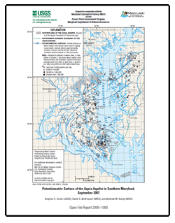
AbstractThis report presents a map showing the potentiometric surface of the Aquia aquifer in the Aquia Formation of Paleocene age in Southern Maryland during September 2007. The map is based on water-level measurements in 85 wells. The highest measured water level was 50 feet above sea level near the northern boundary and outcrop area of the aquifer in the central part of Anne Arundel County, and was below sea level just south of this area and in the remainder of the study area. The hydraulic gradient increased southeastward toward an extensive cone of depression around well fields at Lexington Park and Solomons Island. A water level measured west of the Cheasapeake Beach area has declined to 57 feet below sea level due to increased withdrawals. The lowest water level measured was 162 feet below sea level at the center of a cone of depression at Lexington Park. |
For additional information contact: Part or all of this report is presented in Portable Document Format (PDF); the latest version of Adobe Reader or similar software is required to view it. Download the latest version of Adobe Reader, free of charge. |
Curtin, S.E., Andreasen, D.C., and Staley, A.W., 2009, Potentiometric surface of the Aquia aquifer in Southern Maryland, September 2007: U.S. Geological Survey Open-File Report 2009–1080, 1 map sheet .

![]() U.S. Department of the Interior |
U.S. Geological Survey
U.S. Department of the Interior |
U.S. Geological Survey
URL: https://pubsdata.usgs.gov/pubs/of/2009/1080/
Page Contact Information: Contact USGS
Page Last Modified: Wednesday, 07-Dec-2016 21:54:42 EST
