Open-File Report 2009-1083
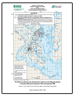
AbstractThis report presents a map showing the change in the potentiometric surface of the Magothy aquifer in the Magothy Formation of Late Cretaceous age in Southern Maryland for September 1975 and September 2007. The map, based on water-level measurements in 51 wells, shows that during the 32-year period, the potentiometric surface had no change at the outcrop area, which is in the northernmost part of the study area, but declined 90 feet at Waldorf. Waldorf is located near the southwesternmost part of the study area, and approaches the downdip boundary of the aquifer. |
For additional information contact: Part or all of this report is presented in Portable Document Format (PDF); the latest version of Adobe Reader or similar software is required to view it. Download the latest version of Adobe Reader, free of charge. |
Curtin, S.E., Andreasen, D.C., and Staley, A.W., 2009, The difference between the potentiometric surfaces of the Magothy aquifer in Southern Maryland, September 1975 and September 2007: U.S. Geological Survey Open-File Report 2009–1083, 1 map sheet.

![]() U.S. Department of the Interior |
U.S. Geological Survey
U.S. Department of the Interior |
U.S. Geological Survey
URL: https://pubsdata.usgs.gov/pubs/of/2009/1083/
Page Contact Information: Contact USGS
Page Last Modified: Wednesday, 07-Dec-2016 21:55:05 EST
