Open-File Report 2009-1084
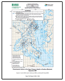
AbstractThis report presents a map showing the potentiometric surface of the upper Patapsco aquifer in the Patapsco Formation of Early Cretaceous age in Southern Maryland during September 2007. The map is based on water-level measurements in 50 wells. The highest measured water level was 120 feet above sea level near the northern boundary and outcrop area of the aquifer in northern Anne Arundel County. From this area, the potentiometric surface declined to the south toward a well field in the Annapolis-Arnold area, and from all directions toward four cones of depression. These cones are located in the Waldorf-La Plata area, Chalk Point-Prince Frederick area, Swan Point subdivision in southern Charles County, and the Lexington Park-St. Inigoes area. The lowest measured ground-water level was 44 feet below sea level at Arnold, 106 feet below sea level south of Waldorf, 54 feet below sea level at Swan Point, 59 feet below sea level at Chalk Point, and 58 feet below sea level at Lexington Park. |
For additional information contact: Part or all of this report is presented in Portable Document Format (PDF); the latest version of Adobe Reader or similar software is required to view it. Download the latest version of Adobe Reader, free of charge. |
Curtin, S.E., Andreasen, D.C., and Staley, A.W., 2009, Potentiometric surface of the Upper Patapsco aquifer in Southern Maryland, September 2007: U.S. Geological Survey Open-File Report 2009–1084, 1 map sheet.

![]() U.S. Department of the Interior |
U.S. Geological Survey
U.S. Department of the Interior |
U.S. Geological Survey
URL: https://pubsdata.usgs.gov/pubs/of/2009/1084/
Page Contact Information: Contact USGS
Page Last Modified: Wednesday, 07-Dec-2016 21:55:08 EST
