Open-File Report 2009-1085
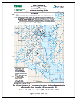
AbstractThis report presents a map showing the change in the potentiometric surface of the upper Patapsco aquifer in the Patapsco Formation of Early Cretaceous age in Southern Maryland for September 1990 and September 2007. The map, based on water-level measurements in 33 wells, shows that during the 17-year period, the change in the potentiometric surface ranged from zero at the edge of the outcrop area in northern Anne Arundel County to a decline of 28 feet at Crofton Meadows, 38 feet at Arnold, 36 feet at Waldorf, 35 feet at the Chalk Point power plant, and 40 feet at Lexington Park. |
For additional information contact: Part or all of this report is presented in Portable Document Format (PDF); the latest version of Adobe Reader or similar software is required to view it. Download the latest version of Adobe Reader, free of charge. |
Curtin, S.E., Andreasen, D.C., and Staley, A.W., 2009, The difference between the potentiometric surfaces of the Upper Patapsco aquifer in Southern Maryland, September 1990 and September 2007: U.S. Geological Survey Open-File Report 2009–1085, 1 map sheet.

![]() U.S. Department of the Interior |
U.S. Geological Survey
U.S. Department of the Interior |
U.S. Geological Survey
URL: https://pubsdata.usgs.gov/pubs/of/2009/1085/
Page Contact Information: Contact USGS
Page Last Modified: Wednesday, 07-Dec-2016 21:55:11 EST
