POTO_AREA: ESRI Format Binary Grid of the Merged Bathymetry and Elevation Data from the Potomac River/Chesapeake Bay Area For Use With USGS Cruise 06018

Metadata also available as - [Outline] - [Parseable text]

Frequently-anticipated questions:


What does this data set describe?

Title:
POTO_AREA: ESRI Format Binary Grid of the Merged Bathymetry and Elevation Data from the Potomac River/Chesapeake Bay Area For Use With USGS Cruise 06018
Abstract:
In order to test hypotheses about groundwater flow under and into Chesapeake Bay, geophysical surveys were conducted by U.S. Geological Survey (USGS) scientists on Chesapeake Bay and the Potomac River Estuary in September 2006. Chesapeake Bay resource managers are concerned about nutrients that are entering the estuary via submarine groundwater discharge, which are contributing to eutrophication. The USGS has performed many related studies in recent years to provide managers with information necessary to make informed decisions about this issue. The research carried out as part of the study described here was designed to help refine nutrient budgets for Chesapeake Bay by characterizing submarine groundwater flow and discharge of groundwater beneath part of the mainstem and a major tributary, the Potomac River Estuary.
  1. How should this data set be cited?

    Cross, VeeAnn A. , 2010, POTO_AREA: ESRI Format Binary Grid of the Merged Bathymetry and Elevation Data from the Potomac River/Chesapeake Bay Area For Use With USGS Cruise 06018: Open-File Report 2009-1151, U.S. Geological Survey, Coastal and Marine Geology Program, Woods Hole Coastal and Marine Science Center, Woods Hole, MA.

    Online Links:

    This is part of the following larger work.

    Cross, VeeAnn A. , Foster, David S. , and Bratton, John F. , 2010, Continuous Resistivity Profiling and Seismic-Reflection Data Collected in 2006 from the Potomac River Estuary, Virginia and Maryland: Open-File Report 2009-1151, U.S. Geological Survey, Coastal and Marine Geology Program, Woods Hole Coastal and Marine Science Center, Woods Hole, MA.

    Online Links:

  2. What geographic area does the data set cover?

    West_Bounding_Coordinate: -77.387222
    East_Bounding_Coordinate: -75.604370
    North_Bounding_Coordinate: 38.729651
    South_Bounding_Coordinate: 37.706801

  3. What does it look like?

    <https://pubs.usgs.gov/of/2009/1151/data/basemap/elevation/poto_area.gif> (GIF)
    Thumbnail image of the color coded relief in the Potomac River Estuary area.

  4. Does the data set describe conditions during a particular time period?

    Calendar_Date: 1998
    Currentness_Reference: Publication data of the original source datasets

  5. What is the general form of this data set?

    Geospatial_Data_Presentation_Form: raster digital data

  6. How does the data set represent geographic features?

    1. How are geographic features stored in the data set?

      This is a Raster data set. It contains the following raster data types:

      • Dimensions 3702 x 5144 x 1, type Grid Cell

    2. What coordinate system is used to represent geographic features?

      Grid_Coordinate_System_Name: Universal Transverse Mercator
      Universal_Transverse_Mercator:
      UTM_Zone_Number: 18
      Transverse_Mercator:
      Scale_Factor_at_Central_Meridian: 0.999600
      Longitude_of_Central_Meridian: -75.000000
      Latitude_of_Projection_Origin: 0.000000
      False_Easting: 500000.000000
      False_Northing: 0.000000

      Planar coordinates are encoded using row and column
      Abscissae (x-coordinates) are specified to the nearest 30.000000
      Ordinates (y-coordinates) are specified to the nearest 30.000000
      Planar coordinates are specified in meters

      The horizontal datum used is North American Datum of 1983.
      The ellipsoid used is Geodetic Reference System 80.
      The semi-major axis of the ellipsoid used is 6378137.000000.
      The flattening of the ellipsoid used is 1/298.257222.

      Vertical_Coordinate_System_Definition:
      Altitude_System_Definition:
      Altitude_Datum_Name: North American Vertical Datum of 1988
      Altitude_Resolution: 1
      Altitude_Distance_Units: meters
      Altitude_Encoding_Method:
      Explicit elevation coordinate included with horizontal coordinates
      Depth_System_Definition:
      Depth_Datum_Name:
      referenced to local tidal datum at the time of the hydrographic survey
      Depth_Resolution: 1
      Depth_Distance_Units: meters
      Depth_Encoding_Method: Explicit depth coordinate included with horizontal coordinates

  7. How does the data set describe geographic features?


Who produced the data set?

  1. Who are the originators of the data set? (may include formal authors, digital compilers, and editors)

  2. Who also contributed to the data set?

  3. To whom should users address questions about the data?

    VeeAnn A. Cross
    U.S. Geological Survey
    Marine Geologist
    Woods Hole Coastal and Marine Science Center
    Woods Hole, MA 02543-1598

    (508) 548-8700 x2251 (voice)
    (508) 457-2310 (FAX)
    vatnipp@usgs.gov


Why was the data set created?

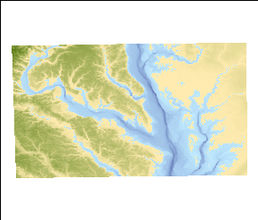
The purpose of this dataset is to provide a seamless elevation/bathymetry grid as a basemap layer for the work in the Potomac River area.


How was the data set created?

  1. From what previous works were the data drawn?

    NED (source 1 of 2)
    U.S. Geological Survey (USGS), EROS Data Center, 1999, National Elevation Dataset: U.S. Geological Survey, Sioux Falls, SD.

    Online Links:

    Type_of_Source_Media: online
    Source_Contribution: Land elevation values.

    EstuaryBathy (source 2 of 2)
    Department of Commerce (DOC), National Oceanic and Atmospheric Adminis, 1998, Chesapeake Bay, VA/MD (M130) Bathymetric Digital Elevation Model (30 meter resolution) Derived From Source Hydrographic Survey Soundings Collected by NOAA: NOAA's Ocean Service, Special Projects (SP), Silver Spring, MD.

    Online Links:

    Type_of_Source_Media: online
    Source_Contribution: Bathymetry values.

  2. How were the data generated, processed, and modified?

    Date: 2006 (process 1 of 8)
    In generating a grid for the area of interest, this required four files to be downloaded from the National Elevation Dataset (NED) site (<http://ned.usgs.gov/> or <http://seamless.usgs.gov/>). The downloaded files were each accompanied by metadata that indicates the publication date of the data as 1999. These original grids are in a geographic coordinate system, NAD83, with a vertical datum of NAVD88. The cell size of these grids is 0.000278 decimal degrees. These files cover the land portion of the area of interest. The cell values where water occurs is usually set to 0 - not true elevation (bathymetry) values. This process step, as well as all subsequent process steps were performed by the same individual - VeeAnn A. Cross.

    Person who carried out this activity:

    VeeAnn A. Cross
    U.S. Geological Survey
    Marine Geologist
    Woods Hole Coastal and Marine Science Center
    Woods Hole, MA 02543-1598

    (508) 548-8700 x2251 (voice)
    (508) 457-2310 (FAX)
    vatnipp@usgs.gov

    Data sources produced in this process:
    • ned_47818044
    • ned_52341366
    • ned_77859792
    • ned_84386099

    Date: 2006 (process 2 of 8)
    Using ArcMap 9.0, Spatial Analyst - Spatial Analyst Toolbar - Raster Calculator I merged all four of these grids together. The raster calculator command was: merge([ned_47818044], [ned_52341366], [ned_77859792], [ned_84386099]). This adds a temporary grid to the ArcMap table of contents. Right mouse click on the layer - Data - Make Permanent to convert the temporary grid to a permanent grid - merge4.

    Data sources used in this process:

    • ned_47818044
    • ned_52341366
    • ned_77859792
    • ned_84386099

    Data sources produced in this process:

    • merge4

    Date: 2006 (process 3 of 8)
    ArcMap 9.0 - ArcToolbox - Data Management Tools - Projections and Transformations - Raster - Project Raster to project the original geographic grid to UTM, Zone 18, NAD83 using the bilinear interpolation. Because both the input and output grids are NAD83, no datum transformation was necessary. All other parameters were left to their default.

    Data sources used in this process:

    • merge4

    Data sources produced in this process:

    • merge4_utm

    Date: 2006 (process 4 of 8)
    For the bathymetry portion of the area of interest, the Estuarine Bathymetry project of NOAA provided the data - <http://estuarinebathymetry.noaa.gov/>. To cover the whole Chesapeake Bay area, three data files were downloaded: M130_37076C5_BIG1.dem, M130_38076D4_BIG2.dem, and M130_39076C2_BIG3.dem. These files were accompanied by metadata indicating the publication date for these data as 1998. In addition, a complete explanation of their processing history is included. The original projection of the data is UTM, zone 18, NAD27 with a cell size of 30 meters. The vertical datum for the bathymetry is referenced to local tidal datum at the time of the hydrographic surveys that make up the dataset. The vertical unit is meters.

    Data sources produced in this process:

    • M130_37076C5_BIG1.dem
    • M130_38076D4_BIG2.dem
    • M130_39076C2_BIG3.dem

    Date: 2006 (process 5 of 8)
    The Digital Elevation Model (DEM) estuarine files needed to be converted from the USGS DEM format to ESRI grid format. To do that, ArcMap 9.0 - ArcToolbox - Conversion Tools - To Raster - DEM to Raster. The output data type is float, with the Z-factor left to the default value of 1.

    Data sources used in this process:

    • M130_37076C5_BIG1.dem
    • M130_38076D4_BIG2.dem
    • M130_39076C2_BIG3.dem

    Data sources produced in this process:

    • big1
    • big2
    • big3

    Date: 2006 (process 6 of 8)
    These grids then needed to be projected to UTM, Zone 18, NAD83 - basically just a datum transformation. To do this, ArcMap 9.0 - Data Management Tools - Projections and Transformations - Raster - Project Raster. The geographic transformation used was NAD_1927_to NAD_1980_NADCON. The resampling method was bilinear.

    Data sources used in this process:

    • big1
    • big2
    • big3

    Data sources produced in this process:

    • big1_nad83
    • big2_nad83
    • big3_nad83

    Date: 2006 (process 7 of 8)
    To combine the land and the bathymetry used ArcMap 9.0 - Spatial Analyst Toolbar - Raster Calculator. Using the Merge command within raster calculator: merge(big1_nad83, big2_nad83, big3_nad83, merge4_utm). The order of the file inputs is important, as the last raster listed has the lowest priority. In this case, the land grid (merge4_utm) needed to be last so that the true bathymetry values overwrote the zero values of the water areas in the land grid. The result of this merge command generated a temporary grid in the ArcMap table of contents.

    Data sources used in this process:

    • big1_nad83
    • big2_nad83
    • big3_nad83
    • merge4_utm

    Data sources produced in this process:

    • temporary grid

    Date: 2006 (process 8 of 8)
    A graphic polygon was drawn indicating the area of interest. VACExtras 1.95 (a Woods Hole extension to ArcMap) was then used to clip the temporary merged grid with the polygon graphic using Clip Grid with Graphic. This in turn created a temporary grid that was then converted to a permanent file by right-clicking on the layer in the table of contents - Data - Make Permanent.

    Data sources used in this process:

    • temporary grid

    Data sources produced in this process:

    • poto_area

  3. What similar or related data should the user be aware of?

    Department of Commerce (DOC), National Oceanic and Atmospheric Adminis, 1998, Chesapeake Bay, VA/MD (M130) Bathymetric Digital Elevation Model (30 meter resolution) Derived From Source Hydrographic Survey Soundings Collected by NOAA: NOAA's Ocean Service, Special Projects (SP), Silver Spring, MD.

    Online Links:

    U.S. Geological Survey (USGS), EROS Data Center, 1999, National Elevation Dataset: U.S. Geological Survey, Sioux Falls, SD.

    Online Links:


How reliable are the data; what problems remain in the data set?

  1. How well have the observations been checked?

  2. How accurate are the geographic locations?

    This grid is a combination of two dataset that provide the best-available data for the land elevations and the bathymetry of Chesapeake Bay. The 7.5-minute elevation data for the conterminous United States are the primary initial source data for the land elevation and were acquired from the National Elevation Dataset (NED). The bathymetry dataset was acquired from the NOAA estuarine bathymetry website. This dataset was derived from two hundred ninety-seven surveys dating from 1850 to 1993. The NED website does not specify any value for horizontal accuracy. According to the metadata accompanying the bathymetry dataset, the horizontal accuracy is expressed as an estimated root mean square error (RMSE). The estimate of the RMSE is based upon horizontal accuracy tests of the source soundings used to generate the DEM. As a first approximation the locational accuracy of the source soundings are 0.0015 m at source "Smooth Sheet" scale (120 m @ 1:80,000 to 15 m @ 1:10,000). Smooth Sheets are maps generated as a principle product of each (historic) hydrographic survey with fully corrected soundings plotted on them. In both cases the user needs to refer to the original datasets to establish the details of the data and their estimates of accuracy.

  3. How accurate are the heights or depths?

    The metadata accompanying the NED dataset does not specify a vertical accuracy. However, the website indicates the vertical accuracy of the National Elevation Dataset (NED) varies spatially because of the variable quality of the source digital elevation models (DEMs). As such, the NED inherits the accuracy of the source DEMs. The most recently published figure of overall absolute vertical accuracy expressed as the root mean square error (RMSE) is 2.44 meters. The estuarine bathymetry metadata indicates the vertical RMSE statistic is used to describe the vertical accuracy of a DEM. It encompasses both random and systematic errors introduced during production of the data. The RMSE is encoded in element number 5 of record C of the DEM. This accuracy estimate includes components related to quantization of the source soundings (1.3 to 0.15 m), the systematic editing of the source data (1percentor 0.10m), un-sampled bathymetric features (estimated at less than 5percentof depth), time related changes (erosion, deposition, and seismic shifts), and dredging operations (cut and fill). It is estimated that the accuracy of the Bathymetric DEMs is 2 percent of depth or 1 meter for depths grater than 20 meters and 2 percentof depth or 0.20 meters for depths shallower than 20 meters. THESE DEMs SHOULD NOT BE USED FOR NAVIGATION. The two datasets used to create this merged product are referenced to different vertical datums. The NED data use a vertical datum of NAVD88 while the estuarine data simply specifies the vertical datum as referenced to the local tidal datum at the time of the hydrographic survey. No adjustment was made to the individual datasets to attempt to eliminate this discrepancy. The user needs to refer to the original datasets to establish the details of the data and their estimates of accuracy.

  4. Where are the gaps in the data? What is missing?

    This dataset represent complete elevation information for the area of interest.

  5. How consistent are the relationships among the observations, including topology?


How can someone get a copy of the data set?

Are there legal restrictions on access or use of the data?

Access_Constraints: None.
Use_Constraints:
The public domain data from the U.S. Government are freely redistributable with proper metadata and source attribution. Please recognize the U.S. Geological Survey and the National Oceanic and Atmospheric Administration (NOAA) National Ocean Service (NOS) as the originators of the individual datasets. These data are not to be used for navigation.

  1. Who distributes the data set? (Distributor 1 of 1)

    VeeAnn A. Cross
    U.S. Geological Survey
    Marine Geologist
    Woods Hole Coastal and Marine Science Center
    Woods Hole, MA 02543-1598

    (508) 548-8700 x2251 (voice)
    (508) 457-2310 (FAX)
    vatnipp@usgs.gov

  2. What's the catalog number I need to order this data set?

    Downloadable Data

  3. What legal disclaimers am I supposed to read?

    Neither the U.S. government, the Department of the Interior, nor the USGS, nor any of their employees, contractors, or subcontractors, make any warranty, express or implied, nor assume any legal liability or responsibility for the accuracy, completeness, or usefulness of any information, apparatus, product, or process disclosed, nor represent that its use would not infringe on privately owned rights. The act of distribution shall not constitute any such warranty, and no responsibility is assumed by the USGS in the use of these data or related materials. Any use of trade, product, or firm names is for descriptive purposes only and does not imply endorsement by the U.S. Government.

  4. How can I download or order the data?

  5. What hardware or software do I need in order to use the data set?

    This WinZip file contains data available in ESRI binary grid format. The user must have software capable of uncompressing the WinZip file and reading/displaying the raster data.


Who wrote the metadata?

Dates:
Last modified: 25-Mar-2010
Metadata author:
VeeAnn A. Cross
U.S. Geological Survey
Marine Geologist
Woods Hole Coastal and Marine Science Center
Woods Hole, MA 02543-1598

(508) 548-8700 x2251 (voice)
(508) 457-2310 (FAX)
vatnipp@usgs.gov

Metadata standard:
FGDC Content Standards for Digital Geospatial Metadata (FGDC-STD-001-1998)
Metadata extensions used:


Generated by mp version 2.9.6 on Thu Mar 25 13:04:17 2010