Open-File Report 2009–1188
Summary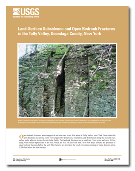
Open bedrock fractures were mapped in and near two brine field areas in Tully Valley, New York. More than 400 open fractures and closed joints were mapped for dimension, orientation, and distribution along the east and west valley walls adjacent to two former brine fields. The bedrock fractures are as much as 2 feet wide and over 50 feet deep, while linear depressions in the soil, which are 3 to 10 feet wide and 3 to 6 feet deep, indicate the presence of open bedrock fractures below the soil. The fractures are probably the result of solution mining of halite deposits about 1,200 feet below the land surface. IntroductionIn the late 1880s, solution mining of halite (rock salt) beds in the southern Tully Valley produced brine used by the Solvay Process Company to manufacture soda ash in Syracuse, N.Y. During the nearly 100 years of solution mining, approximately 150 vertical feet of halite were removed from layers 1,200 feet below the valley floor. Underground solution cavities collapsed, eventually causing land-surface subsidence in the solution-mined areas. The adjacent bedrock valley walls responded to this subsidence by creating open bedrock fractures that follow naturally-formed joint orientations in the bedrock. The purpose of this report is to document the character of open bedrock fractures and closed joints in relation to regional joint orientations in and near the two brine fields. A brief history of the brine fields and associated subsidence is presented. The fractures and joints are described, and their location and orientation are shown in maps and joint rose diagrams. |
Posted December 2009 For additional information contact: Part or all of this report is presented in Portable Document Format (PDF); the latest version of Adobe Reader or similar software is required to view it. Download the latest version of Adobe Reader, free of charge. |
Hackett, W.R., Gleason, G.C., and Kappel, W.M., 2009, Land-surface subsidence and open bedrock fractures in the Tully Valley, Onondaga County, New York: U.S. Geological Survey Open-File Report 2009-1188, 16 p.

![]() U.S. Department of the Interior |
U.S. Geological Survey
U.S. Department of the Interior |
U.S. Geological Survey
[an error occurred while processing this directive]
URL: https://pubsdata.usgs.gov
Page Contact Information: Contact USGS
Page Last Modified: Wednesday, 07-Dec-2016 22:17:01 EST
