NLNB_UTM: 4-m Grid of Combined Multibeam and LIDAR Bathymetry from National Oceanic and Atmospheric Administration (NOAA) Surveys H11441, H11442, H11224, and H11225 offshore of New London and Niantic, Connecticut (UTM Zone 18, NAD83)

Metadata also available as [Outline] - [Parseable text]

Frequently-anticipated questions:


What does this data set describe?

Title:
NLNB_UTM: 4-m Grid of Combined Multibeam and LIDAR Bathymetry from National Oceanic and Atmospheric Administration (NOAA) Surveys H11441, H11442, H11224, and H11225 offshore of New London and Niantic, Connecticut (UTM Zone 18, NAD83)
Abstract:
Nearshore areas within Long Island Sound are of great interest to the Connecticut and New York research and management communities because of their ecological, recreational, and commercial importance. However, although advances in multibeam echosounder technology permit the construction of detailed digital terrain models of seafloor topography within deeper waters, limitations inherent with collecting multibeam data make using this technology in shallower waters (<10-m deep) more difficult and expensive. These limitations have often resulted in gaps of no data between multibeam bathymetric datasets and the adjacent shoreline. To address this problem, complete-coverage multibeam bathymetry acquired offshore of New London and Niantic Bay, Connecticut, has been integrated with hydrographic LIDAR acquired along the nearshore. The result is a more continuous seafloor perspective and a much smaller gap between the digital bathymetric data and the shoreline. These datasets are provided as ESRI grid and GeoTIFF formats in order to facilitate access, compatibility, and utility.
  1. How should this data set be cited?

    National Oceanic and Atmospheric Administration, and U.S. Geological Survey, 2010, NLNB_UTM: 4-m Grid of Combined Multibeam and LIDAR Bathymetry from National Oceanic and Atmospheric Administration (NOAA) Surveys H11441, H11442, H11224, and H11225 offshore of New London and Niantic, Connecticut (UTM Zone 18, NAD83): Open-File Report 2009-1231, U.S. Geological Survey, Coastal and Marine Geology Program, USGS Woods Hole Coastal and Marine Science Center, Woods Hole, MA.

    Online Links:

    This is part of the following larger work.

    Poppe, L.J., Danforth, W.W., McMullen, K.Y., Parker, C.E., Lewit, P.G., and Doran, E.F., 2010, Integrated Multibeam and LIDAR Bathymetry Data Offshore of New London and Niantic, Connecticut: Open-File Report 2009-1231, U.S. Geological Survey, Coastal and Marine Geology Program, USGS Woods Hole Coastal and Marine Science Center, Woods Hole, MA.

    Online Links:

  2. What geographic area does the data set cover?

    West_Bounding_Coordinate: -72.252716
    East_Bounding_Coordinate: -71.983749
    North_Bounding_Coordinate: 41.380109
    South_Bounding_Coordinate: 41.237292

  3. What does it look like?

    <https://pubs.usgs.gov/of/2009/1231/data/bathy/grids/utmcombined/nlnb_utm.jpg> (JPEG)
    Thumbnail image showing the 4-m gridded multibeam and LIDAR bathymetry collected during NOAA surveys H11441, H11442, H11224, and H11225 in Geographic

  4. Does the data set describe conditions during a particular time period?

    Beginning_Date: 20-Jan-2004
    Ending_Date: 22-May-2005
    Currentness_Reference:
    ground condition (See the source citation in the lineage section for individual component's specific dates.)

  5. What is the general form of this data set?

    Geospatial_Data_Presentation_Form: raster digital data

  6. How does the data set represent geographic features?

    1. How are geographic features stored in the data set?

      This is a Raster data set. It contains the following raster data types:

      • Dimensions 3785 x 5509 x 1, type Grid Cell

    2. What coordinate system is used to represent geographic features?

      Grid_Coordinate_System_Name: Universal Transverse Mercator
      Universal_Transverse_Mercator:
      UTM_Zone_Number: 18
      Transverse_Mercator:
      Scale_Factor_at_Central_Meridian: 0.999600
      Longitude_of_Central_Meridian: -75.000000
      Latitude_of_Projection_Origin: 0.000000
      False_Easting: 500000.000000
      False_Northing: 0.000000

      Planar coordinates are encoded using row and column
      Abscissae (x-coordinates) are specified to the nearest 4.000726
      Ordinates (y-coordinates) are specified to the nearest 4.000726
      Planar coordinates are specified in meters

      The horizontal datum used is North American Datum of 1983.
      The ellipsoid used is Geodetic Reference System 80.
      The semi-major axis of the ellipsoid used is 6378137.000000.
      The flattening of the ellipsoid used is 1/298.257222.

      Vertical_Coordinate_System_Definition:
      Depth_System_Definition:
      Depth_Datum_Name: Mean lower low water
      Depth_Resolution: 0.1
      Depth_Distance_Units: meters
      Depth_Encoding_Method: Explicit depth coordinate included with horizontal coordinates

  7. How does the data set describe geographic features?

    Entity_and_Attribute_Overview:
    A 4-m grid of the combined multibeam and LIDAR bathymetry from NOAA surveys H11441, H11442, H11224, and H11225 in the UTM Zone 18, NAD83 coordinate system.


Who produced the data set?

  1. Who are the originators of the data set? (may include formal authors, digital compilers, and editors)

  2. Who also contributed to the data set?

  3. To whom should users address questions about the data?

    U.S. Geological Survey
    c/o Larry Poppe
    Geologist
    384 Woods Hole Road
    Woods Hole, MA 02543-1598
    USA

    (508) 548-8700 x2314 (voice)
    (508) 457-2310 (FAX)
    lpoppe@usgs.gov


Why was the data set created?

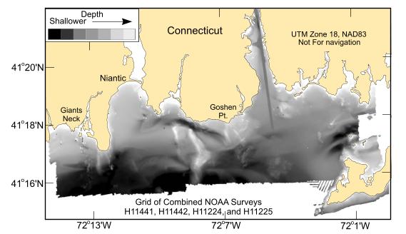
To release a 4-m grid of the combined multibeam and LIDAR bathymetry generated during NOAA surveys H11441, H11442, H11224, and H11225 offshore of New London and Niantic, Connecticut in UTM Zone 18, NAD83.


How was the data set created?

  1. From what previous works were the data drawn?

    (source 1 of 4)
    National Ocean Survey, National Oceanic and Atmospheric Adminis, Unpublished Material, H11441 bathymetry.

    Type_of_Source_Media: disc
    Source_Contribution: Original processed multibeam bathymetric data.

    (source 2 of 4)
    National Ocean Survey, National Oceanic and Atmospheric Adminis, Unpublished Material, H11224 bathymetry.

    Type_of_Source_Media: disc
    Source_Contribution: Original processed LIDAR bathymetric data.

    (source 3 of 4)
    National Ocean Survey, National Oceanic and Atmospheric Adminis, Unpublished Material, H11442 bathymetry.

    Type_of_Source_Media: disc
    Source_Contribution: Original processed multibeam bathymetric data.

    (source 4 of 4)
    National Ocean Survey, National Oceanic and Atmospheric Adminis, Unpublished Material, H11225 bathymetry.

    Type_of_Source_Media: disc
    Source_Contribution: Original processed LIDAR bathymetric data.

  2. How were the data generated, processed, and modified?

    Date: 2005 (process 1 of 7)
    Two 8.5-m aluminum Jensen launches deployed from the NOAA Ship Thomas Jefferson were used to acquire the multibeam echosounder (MBES) bathymetric data for surveys H11441 and H11442 during April - May 2005 off New London, Connecticut. Although most of the deeper parts of these surveys were completely covered during MBES acquisition, coverage in the shallower areas (<10 m) was limited to 'postage stamp' developments around target areas and reconnaissance cross lines. The MBES data were collected with hull-mounted RESON SeaBat 240-kHz 8101 and 455-kHz 8125 shallow-water systems. These systems measure two-way sound travel time across a 150-degree swath and 120-degree swath, respectively. The SeaBat 8101 has 101 beams at a 1.5-degree beam spacing. The SeaBat 8125 has 240 beams with a cross-track beam width of 0.5 degrees at nadir. Original horizontal resolution of the MBES data was 1 m; vertical resolution of the MBES data is about 0.5% of the water depth. The bathymetric data were acquired in XTF (extended Triton data format) and processed by NOAA using CARIS HIPS (Hydrographic Image Processing System) software for quality control, to incorporate sound velocity and tidal corrections, and to produce the continuous digital terrain model. Navigation was by TSS POS/MV 320 differential GPS-assisted inertial navigation systems; the differential GPS beacons used were from Moriches, New York, and Sandy Hook, New Jersey. HYPACK MAX was used for acquisition line navigation. Sound velocity corrections were derived using frequent SEACAT CTD (conductivity-temperature-depth) profiles. Typically, a CTD cast was conducted every four to six hours of MBES acquisition. Tidal zone corrections were calculated from data acquired from National Water Level Observation stations at New London, Connecticut and Montauk, New York. Vertical datum is mean lower low water. Individuals interested in detail descriptions of the MBES acquisition and processing should consult the descriptive reports. Eleven reconnaissance cruises were conducted aboard a leased lobster boat to monitor water clarity prior to commencement of airborne LIDAR operations of surveys H11224 and H11225. These cruises, which utilized Secchi disks to determine water clarity, were conducted between the Connecticut River and Fishers Island during May 9, 2003 and January 11, 2004, when water clarity was deemed adequate. The LIDAR (light detection and ranging) data were acquired by Tenix LADS, Inc. during January 25 - March 3, 2004 with a LADS Mk II system. Airborne survey operations were conducted aboard a Dash 8-202 series aircraft with a Nd:YAG laser at heights between 1,200 and 2,200 feet, at ground speeds between 140 and 210 knots, and at 4x4 and 3x3-m laser-spot spacings. Green laser pulses were scanned beneath the aircraft in a rectilinear pattern. The returned green-laser energy reflected from the sea surface and seafloor were captured and digitally recorded. Received infrared laser energy, supplemented by an Altitude Heading Reference System (AHRS) inertial height reference and kinematic GPS, determined the height of the aircraft. Real-time positioning was provided by WADGPS (wide area differential global positioning system). Acquired data were processed with CARIS HIPS. Individuals interested in detail descriptions of the LIDAR acquisition and processing should consult the descriptive reports. Vertical datum is mean lower low water; X and Y units are meters; UTM Zone 18, NAD83. The final CARIS combined base surfaces were produced at a 4-m cell size for surveys H11441, H11224, and H11225; the final CARIS combined base surface for survey H11442 was produced at a 3-m cell size.

    Person who carried out this activity:

    National Oceanic and Atmospheric Administration
    c/o Marc Moser
    Field Operations Officer
    439 West York Street
    Norfolk, VA 23510
    USA

    757-441-6746 (voice)
    marc.s.moser@noaa.gov

    Data sources produced in this process:
    • H11441 CARIS HIPS database
    • H11224 CARIS HIPS database
    • H11442 CARIS HIPS database
    • H11225 CARIS HIPS database

    Date: 2009 (process 2 of 7)
    The CARIS field sheets for four surveys were inspected to determine if there was vertical and/or horizontal offsets where the surveys overlapped. NOAA LIDAR surveys (H11224 and H11225) showed no relative offset in either the vertical or horizontal direction. The same was found for the two adjacent NOAA multibeam surveys (H11441 and H11442). However, a consistent 25-cm vertical offset was found between the multibeam and LIDAR data sets, with the multibeam data being consistently 25 cm shallower than the overlapping LIDAR survey. To correct this problem, it was decided that multibeam surveys H11441 and H11442 would be offset (deeper) by 25 cm and thus referenced to LIDAR surveys H11224 and H11225. After reviewing the Data Acquisition and Processing Reports (DAPR) in addition to the Descriptive Report (DR) for each of the 4 surveys, 25 cm is within the vertical error budget as reported by Tenix for the LADS system, and as reported for the Reson 8101 and 8125 systerms installed on the NOAA launches. Vertical control was the same for all surveys. Since the 25 cm offset was not outside of the error analyses for all surveys, it was decided to reference the multibeam data to the LIDAR data by lowering the multibeam depth soundings, mainly to keep the 0 LIDAR depth contour (sea surface as obtained by the LADS system) at sea level, and partly because the Tenix LADS surveys were conducted using real-time kinematic GPS techniques and judged to be accurate in the vertical dimension.

    Person who carried out this activity:

    Bill Danforth
    U.S. Geological Survey
    Geologist
    384 Woods Hole Road
    Woods Hole, MA 02543-1598

    508-548-8700 x2274 (voice)
    508-457-2310 (FAX)
    bdanforth@usgs.gov

    Data sources used in this process:
    • H11441 CARIS HIPS database
    • H11442 CARIS HIPS database
    • H11224 CARIS HIPS database
    • H11225 CARIS HIPS database

    Date: 2009 (process 3 of 7)
    The field sheets from surveys H11441, H11442, H11224, and H11225 (average depths, not the shoal based field sheets) were imported into the Fledermaus v6.7 program DMagic to make equivalent digital terrain model (DTM) files. The floating piont format for each sounding depth point is preserved during data import. Additionally, these fieldsheets were imported into DMagic as "gridded data", therefore re-gridding of data did not occur during the import process and thus preserved the original resolutions of the CARIS fieldsheets: H11441 4 meter cell size H11442 3 meter cell size H11224 4 meter cell size H11225 4 meter cell size The H11441 and H11442 DTM files were then exported as an ESRI ASCII raster file from the DMagic program.

    Person who carried out this activity:

    Bill Danforth
    U.S. Geological Survey
    Geologist
    384 Woods Hole Road
    Woods Hole, MA 02543
    USA

    508-548-8700 x2274 (voice)
    508-457-2310 (FAX)
    bdanforth@usgs.gov

    Data sources used in this process:
    • H11441 CARIS HIPS database
    • H11442 CARIS HIPS database
    • H11224 CARIS HIPS database
    • H11225 CARIS HIPS database

    Data sources produced in this process:

    • h11441.dtm
    • h11442.dtm
    • h11224.dtm
    • h11225.dtm
    • h11441.asc
    • h11442.asc

    Date: 2009 (process 4 of 7)
    The ESRI ASCII raster files were imported into ArcMap v9.3 using the ASCII to Raster tool (ArcToolbox, Conversion Tools, To Raster). The only option set here is to import each sounding grid cell value as a floating point number. Subsequently, 25 cm was added to each multibeam survey (H11441 and H11442) raster grid cell, creating a new raster that could now be combined with the LIDAR data sets. Each survey raster file was then exported out of ArcMap using the Raster to ASCII tool (ArcToolbox, Conversion Tools, From Raster).

    Person who carried out this activity:

    Bill Danforth
    U.S. Geological Survey
    Geologist
    384 Woods Hole Road
    Woods Hole, MA 02543-1598

    508-548-8700 x2274 (voice)
    508-457-2310 (FAX)
    bdanforth@usgs.gov

    Data sources used in this process:
    • h11441.asc
    • h11442.asc

    Data sources produced in this process:

    • h11441.asc
    • h11442.asc

    Date: 2009 (process 5 of 7)
    The adjusted multibeam raster was imported back into the Fledermaus v6.7 DMagic program in order to create new DTM files that could be combined with the LIDAR DTM files. The floating piont format for each sounding depth point is preserved during data import. Additionally, the data from the ArcGIS ASCII raster files were imported into DMagic as "gridded data", therefore re-gridding of data did not occur during the import process and thus preserved the original resolutions of the CARIS fieldsheets.

    Person who carried out this activity:

    Bill Danforth
    U.S. Geological Survey
    Geologist
    384 Woods Hole Road
    Woods Hole, MA 02543-1598

    508-548-8700 x2274 (voice)
    508-457-2310 (FAX)
    bdanforth@usgs.gov

    Data sources used in this process:
    • h11441.asc
    • h11442.asc

    Data sources produced in this process:

    • h11441.dtm
    • h11442.dtm

    Date: 2009 (process 6 of 7)
    The DTM files from surveys H11441 and H11442 (now 25 cm deeper) and surveys H11224 and H11225 were combined into one 4-m grid file using the Fledermaus command line option dtmmerge and the combined H11441-H11442-H11224-H11225 grid was exported from DMagic as an ESRI ASCII raster file. The dtmmerge option combines the input grid files and sets the resolution of the output combined grid to the lowest resolution input grid, in this case the 4-meter LIDAR grid. Additionally the output soundings for the combined grid is based on the average of the nearest input grid soundings for a particular output grid cell. The command line used was:
    dtmmerge -in h11225.dtm h11224.dtm h11441.dtm h11442.dtm -out nlnb.dtm -cellsize 4.0 -mode average

    Person who carried out this activity:

    Bill Danforth
    U.S. Geological Survey
    Geologist
    384 Woods Hole Road
    Woods Hole, MA 02453-1598

    508-548-8700 x2274 (voice)
    508-457-2310 (FAX)
    bdanforth@usgs.gov

    Data sources used in this process:
    • h11441.dtm
    • h11442.dtm
    • h11224.dtm
    • h11225.dtm

    Data sources produced in this process:

    • nlnb.asc

    Date: 2009 (process 7 of 7)
    The ESRI ASCII raster file was then converted into raster within ArcToolbox v9.3 using the ASCII to Raster conversion tool.

    Person who carried out this activity:

    Bill Danforth
    U.S. Geological Survey
    Geologist
    384 Woods Hole Raod
    Woods Hole, MA 02453-1598

    508-548-8700 x2274 (voice)
    508-457-2310 (FAX)
    bdanforth@usgs.gov

    Data sources used in this process:
    • nlnb.asc

    Data sources produced in this process:

    • nlnb_utm

  3. What similar or related data should the user be aware of?

    Christman, Emily B. , 2005, H11441: Descriptive Report H11441, National Ocean Survey, National Oceanic and Atmospheric Administration, Atlantic Hydrographic Branch, Norfolk, VA.

    Online Links:

    Stephenson, Darren, 2004, H11224: Descriptive Report H11224, National Ocean Survey, National Oceanic and Atmospheric Administration, Atlantic Hydrographic Branch, Norfolk, VA.

    Online Links:

    Poppe, L.J., Ackerman, S.D., Doran, E.F., Beaver, A.J., Crocker, J.M., and Schattgen, P.T., 2006, Interpolation of reconnaissance multibeam bathymetry from north-central Long Island Sound: Open-File Report 2005-1145, U.S. Geological Survey, Coastal and Marine Geology Program, Woods Hole Coastal and Marine Science Center, Woods Hole, MA.

    Online Links:

    Christman, Emily B. , 2005, H11442: Descriptive Report H11442, National Ocean Survey, National Oceanic and Atmospheric Administration, Atlantic Hydrographic Branch, Norfolk, VA.

    Online Links:

    Stephenson, Darren, 2004, H11225: Descriptive Report H11225, National Ocean Survey, National Oceanic and Atmospheric Administration, Atlantic Hydrographic Branch, Norfolk, VA.

    Online Links:

    Other_Citation_Details:
    Poppe, L.J., Lewis, R.S., Denny, J.F., Parolski, K.F., DiGiacomo-Cohen, M.L., and Tolderlund, D.S., 1998, Sidescan sonar image, surficial geologic interpretation, and bathymetry of the Long Island Sound sea floor in Niantic Bay, Connecticut: U.S. Geological Survey Geologic Investigations Map I-2625, U.S. Geological Survey, Coastal and Marine Geology Program, Woods Hole Coastal and Marine Science Center, Woods Hole, MA.


How reliable are the data; what problems remain in the data set?

  1. How well have the observations been checked?

  2. How accurate are the geographic locations?

    Horizontal position of the launches acquiring multibeam bathymetry were determined using GPS corrected by U.S. Coast Guard differential GPS beacon stations at Moriches, New York, and Sandy Hook, New Jersey. Real-time positioning during LIDAR acquisition was obtained by an Ashtech GG24 GPS receiver combined with Thales GeoSolutions Wide Area DGPS. Original horizontal resolution of the MBES data was 1 m; the final CARIS combined base surfaces for the MBES data were produced at a 4-m cell size for survey H11441 and a 3-m cell size for survey H11442; original cell size of the gridded LIDAR data was primarily 4 m.

  3. How accurate are the heights or depths?

    Attitude of the launches (e.g. pitch, roll, and heave) acquiring multibeam bathymetry were monitored by an Applanix TSS POS/MV 320 Version 3 GPS aided navigation system. Real-time positioning during LIDAR acquisition was obtained by an Ashtech GG24 GPS receiver combined with Thales GeoSolutions Wide Area DGPS. Ashtech Z12 GPS receivers, provided as part of the Airborne System and Ground Systems, also logged GPS data on the aircraft and at a locally established base station to provide post processed KGPS position solutions. Received infrared laser energy, supplemented by an Altitude Heading Reference System (AHRS) inertial height reference and kinematic GPS, determined the height of the aircraft. The vertical resolution of the original bathymetry data is approximately 0.5% of the water depth.

  4. Where are the gaps in the data? What is missing?

    All collected data were processed and used to produce this dataset.

  5. How consistent are the relationships among the observations, including topology?

    No additional checks for consistency were performed on this data.


How can someone get a copy of the data set?

Are there legal restrictions on access or use of the data?

Access_Constraints: None
Use_Constraints:
Data are not to be used for navigation purposes.
Public domain data are freely redistributable with proper metadata and source attribution. Please recognize the National Oceanic and Atmospheric Administration (NOAA) and U.S. Geological Survey (USGS) as the originators of this information.

  1. Who distributes the data set? (Distributor 1 of 1)

    U.S. Geological Survey
    c/o Larry Poppe
    Geologist
    384 Woods Hole Road
    Woods Hole, MA 02543-1598
    USA

    (508) 548-8700 x2314 (voice)
    (508) 457-2310 (FAX)
    lpoppe@usgs.gov

  2. What's the catalog number I need to order this data set?

    Downloadable Data

  3. What legal disclaimers am I supposed to read?

    Neither the U.S. Government, the Department of the Interior, nor the USGS, nor the National Oceanic and Atmospheric Administration (NOAA), nor the Connecticut Department of Environmental Protection (CT DEP) nor any of their employees, contractors, or subcontractors, make any warranty, express or implied, nor assume any legal liability or responsibility for the accuracy, completeness, or usefulness of any information, apparatus, product, or process disclosed, nor represent that its use would not infringe on privately owned rights. The act of distribution shall not constitute any such warranty, and no responsibility is assumed by the USGS, NOAA, or the CT DEP in the use of these data or related materials. Any use of trade, product, or firm names is for descriptive purposes only and does not imply endorsement by the U.S. Government.

  4. How can I download or order the data?

  5. What hardware or software do I need in order to use the data set?

    The user must have a program capable of reading the ESRI grid data format. The user must have software capable of uncompressing archived zip files, such as WinZip or Pkware.


Who wrote the metadata?

Dates:
Last modified: 08-Dec-2009
Metadata author:
Larry Poppe
U.S. Geological Survey
Geologist
384 Woods Hole Road
Woods Hole, MA 02543-1598
USA

(508) 548-8700 x2314 (voice)
(508) 457-2310 (FAX)
lpoppe@usgs.gov

Metadata standard:
FGDC Content Standards for Digital Geospatial Metadata (FGDC-STD-001-1998)
Metadata extensions used:


Generated by mp version 2.9.6 on Tue Dec 08 07:16:19 2009