More information about the individual USGS surveys conducted as part of the northern Cape Cod Bay project can be found on the Woods Hole Coastal and Marine Science Center Field Activity webpage:
06012: <http://quashnet.er.usgs.gov/data/2006/06012/> 07001: <http://quashnet.er.usgs.gov/data/2007/07001/> 07002: <http://quashnet.er.usgs.gov/data/2007/07002/> 07003: <http://quashnet.er.usgs.gov/data/2007/07003/> 08002: <http://quashnet.er.usgs.gov/data/2008/08002/>
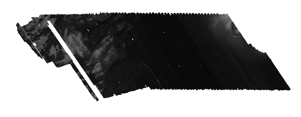
U.S. Geological Survey, 2010, CCB_KLEIN_BS_1M.TIF: One meter acoustic backscatter mosaic acquired using a Klein 3000 sidescan sonar offshore of Massachusetts within northern Cape Cod Bay (GeoTIFF Image, UTM Zone 19N).: Open-File Report 2010-1006, U.S. Geological Survey, Coastal and Marine Geology Program, Woods Hole Coastal and Marine Science Center, Woods Hole, Massachusetts.This is part of the following larger work.Online Links:
- <https://pubs.usgs.gov/of/2010/1006/GIS/raster/backscatter/CCB_Klein_bs_1m.zip>
- <https://pubs.usgs.gov/of/2010/1006/html/appendix1.html>
Andrews, Brian D. , Ackerman, Seth D. , Baldwin, Wayne E. , and Barnhardt, Walter A. , 2010, Geophysical and Sampling Data from the Inner Continental Shelf: Northern Cape Cod Bay, Massachusetts.: Open-File Report 2010-1006, U.S. Geological Survey, Coastal and Marine Geology Program, Woods Hole Coastal and Marine Science Center, Woods Hole, Massachusetts.Online Links:
This is a Raster data set. It contains the following raster data types:
Planar coordinates are encoded using row and column
Abscissae (x-coordinates) are specified to the nearest 1.000000
Ordinates (y-coordinates) are specified to the nearest 1.000000
Planar coordinates are specified in meters
The horizontal datum used is D_WGS_1984.
The ellipsoid used is WGS_1984.
The semi-major axis of the ellipsoid used is 6378137.000000.
The flattening of the ellipsoid used is 1/298.257224.
Sequential unique whole numbers that are automatically generated.
508-548-8700 x2348 (voice)
508-457-2310 (FAX)
bandrews@usgs.gov
The purpose of this GeoTIFF is to publish single mosaic of acoustic backscatter of the seafloor acquired during four surveys using a Klein 3000 sidescan-sonar in the Cape Cod Bay survey area.
Acoustic backscatter data acquisition for field activities 07001 and 08002: The Klein 3000 towfish was deployed from a davit on the port side of the R/V Rafael approximately 1 m astern and 0.5 m below the water surface. These data were acquired using a 75-100 m range(150-200 m total width).
Person who carried out this activity:
508-548-8700 x2348 (voice)
508-457-2310 (FAX)
bandrews@usgs.gov
Person who carried out this activity:
508-548-8700 x2348 (voice)
508-457-2310 (FAX)
bandrews@usgs.gov
Person who carried out this activity:
508-548-8700 x2348 (voice)
508-457-2310 (FAX)
bandrews@usgs.gov
1) The rectified mosaic (*.pix) files from 07001 and 08002 were added to the new mosaic.
2) The rectified mosaic (*.pix) files for 06012 and 07002 were mosaiced together in PCI (CCB_offshore.pix) and then exported to a GeoTIFF (CCB_offshore.tif). The 8-bit range of the image (color stretch) was adjusted to visually match the inshore backscatter data in CCB_Klein_bs_1m.pix.
3) The color adjusted GeoTIFF (CCB_offshore_Adj.tif) was imported back into PCI and mosaicked into the CCB_Klein_bs_1m.pix file to generate a 1-m mosaic of Klein data.
4) The final mosaic (CCB_Klein_bs_1m.pix) was exported to a GeoTIFF (CCB_Klein_bs_1m.tif). A TIFF world file (tfw) was generated for the GeoTIFF using GeoTIFFExaminer (no version).
Person who carried out this activity:
508-548-8700 x2348 (voice)
508-457-2310 (FAX)
bandrews@usgs.gov
Barnhardt, Walter A. , Andrews, Brian D. , and Butman, Bradford, 2006, High-Resolution Mapping of the Inner Continental Shelf: Nahant to Gloucester, Massachusetts: Open-File Report 2005-1293, U.S. Geological Survey, Coastal and Marine Geology Program, Woods Hole Science Center, Woods Hole, MA.Online Links:
Ackerman, Seth D. , Butman, Bradford, Barnhardt, Walter A. , Danforth, William W. , and Crocker, James M. , 2006, High-Resolution Geologic Mapping of the Inner Continental Shelf: Boston Harbor and Approaches, Massachusetts: Open-File Report 2006-1008, U.S. Geological Survey, Coastal and Marine Geology Program, Woods Hole Science Center, Woods Hole, MA.Online Links:
Barnhardt, Walter A. , Andrews, Brian D. , Ackerman, Seth D. , Baldwin, Wayne E. , and Hein, Christopher J. , 2009, High-Resolution Geological Mapping of the Inner Continental Shelf: Cape Ann to Salisbury Beach, Massachusetts: Open-File Report 2007-1373, U.S. Geological Survey, Coastal and Marine Geology Program, Woods Hole Science Center, Woods Hole, MA.Online Links:
Barnhardt, Walter A. , Ackerman, Seth D. , Andrews, Brian D. , and Baldwin, Wayne E. , 2010, Geophysical and Sampling Data from the Inner Continental Shelf: Duxbury to Hull, Massachusetts: Open-File Report 2009-1072, U.S. Geological Survey, Coastal and Marine Geology Program, Woods Hole Science Center, Woods Hole, Massachusetts.Online Links:
Danforth, William W. , 1997, XSonar/ShowImage: A complete system for rapid sidescan-sonar processing and display.: Open-File Report 97-686, U.S. Geological Survey, Woods Hole Science Center, Woods Hole, MA.Online Links:
Image pixel values contain acoustic reflectivity values normalized to an 8-bit data range (0-255). Low-backscatter is represented by dark tones (low values) and high-backscatter is represented by bright tones (high values).
Field activities 06012 and 07002: The Klein 3000 towfish was deployed from the stern A-frame of the R/V Megan T. Miller. Real-time kinematic (RTK) GPS navigation data were provided by an Ashtech Z-Extreme receiver (an Ashtech BR2G DGPS was used as a backup system) and recorded to the raw data files (XTF) via the Klein SonarPro (version 9.6 & 10.0) acquisition software. During some portions of the survey, technical difficulties caused the GPS systems to malfunction and loose the "fixed" RTK signal. When this occurred, the navigation system generally defaulted to a "float" RTK or DGPS signal, or the navigation was lost. When possible, surveying was halted until a reliable GPS signal was restored. A digital cable counter attached to the winch used to deploy the sidescan-sonar towfish measured changes in the amount of cable extended from the A-frame and updated the cable out parameter in SonarPro. Using the cable out value and linear offset between the A-frame and the RTK-GPS antenna, Sonar Pro calculated towfish layback positions in real time and recorded them to the XTF file headers. A conservative estimate of positional accuracy is ± 10 m, but when the navigation system was providing the "fixed" RTK signal, positional accuracy is likely < 1 m. Positional uncertainty arises because layback calculations do not account for fish motion behind the vessel, which is caused by sea state and vessel speed induced changes in the angle and scope of the tow cable.
Field activities 07001 and 08002: The Klein 3000 towfish was deployed from a davit on the port side aft on the R/V Rafael. Real-time kinematic (RTK) GPS navigation data were provided by an Ashtech Z-Surveyor Extreme receiver and recorded to the raw data files (XTF) via the Klein SonarPro (version 9.6 and 10.0) acquisition software. A conservative estimate of positional accuracy is ± 10 m, but when the navigation system was providing the "fixed" RTK signal, positional accuracy is likely <1 m.
This mosaic does not include all acoustic backscatter data collected in the northern Cape Cod Bay survey area. Data collected along transit lines, east-west seismic tie lines and other lines of poor quality were excluded from this mosaic The "mosaic" attribute in the CCB_BackscatterTracklines shapefile published in this report identifies the 626 lines that were included, and the 17 lines that were not included, in this mosaic. A data gap exists in this mosaic where the Klein sidescan winch was inoperable for one day. The backscatter data in this gap is covered by backscatter data acquired with the SEA Ltd. SWATHplus interferometric sonar (CCB_SwathBS_1m.tif).
All sidescan-sonar data in this mosaic were collected with a Klein 3000 dual-frequency (132/445 kHz) sidescan-sonar system. Only the 132-kHz data were used to generate the sidescan-sonar mosaic. All data were processed with the same methods.
Are there legal restrictions on access or use of the data?
- Access_Constraints: None
- Use_Constraints:
- Public domain data from the U.S. Government are freely redistributable with proper metadata and source attribution. Please recognize the U.S. Geological Survey as the source of this information.
508-548-8700 x2348 (voice)
bandrews@usgs.gov
Downloadable Data
Neither the U.S. Government, the Department of the Interior, nor the USGS, nor any of their employees, contractors, or subcontractors, make any warranty, express or implied, nor assume any legal liability or responsibility for the accuracy, completeness, or usefulness of any information, apparatus, product, or process disclosed, nor represent that its use would not infringe on privately owned rights. The act of distribution shall not constitute any such warranty, and no responsibility is assumed by the USGS in the use of these data or related materials. Any use of trade, product, or firm names is for descriptive purposes only and does not imply endorsement by the U.S. Government.
| Data format: | WinZip file contains a GeoTIFF image and associated world file of sidescan-sonar collected within Northern Cape Cod Bay. in format WinZip (version 9.0) Size: 262 Mbytes |
|---|---|
| Network links: |
<https://pubs.usgs.gov/of/2010/1006/GIS/raster/backscatter/CCB_Klein_bs_1m.zip> |
| Media you can order: |
DVD-ROM
(Density 4.75
Gbytes)
(format UDF)
|
This Zip file contains a compressed GeoTIFF image and world file. The user must have software capable of uncompressing the zip file and viewing a GeoTIFF image.
508-548-8700 x2348 (voice)
508-457-2310 (FAX)
bandrews@usgs.gov